Weather
Hermine's Track Shifts: What it May Mean to New Jersey Sunday [WATCH LIVE VIDEO]
"This is certainly not Sandy," Gov. Chris Christie said at a press conference, saying Hermine is still a threat. Watch live beach cams here.

Hermine still poses a threat to New Jersey even as the track has shifted to the east, Gov. Chris Christie said during a Sunday press conference. (For continued updates on the storm, including news on power outages and road closures, sign up for Patch news alerts here.)
"This is certainly not Sandy," Christie said during a mid-day press conference, referring to the 2012 storm that devastated the state and caused billions of dollars in damage.
Christie said the current model shows - at worst - minor flooding, saying he doesn't believe there is a need to order evacuations.
Find out what's happening in Toms Riverfor free with the latest updates from Patch.
"We are prepared if things wobble west," he said.
Read more: UPDATED Timetable Of Tropical Storm Hermine As N.J. Impacts Pushed Later
Find out what's happening in Toms Riverfor free with the latest updates from Patch.
The National Weather Service says the tropical storm - which could still become a hurricane - is expected to stall to the east of the New Jersey shore over the next two days, bringing with it strong winds and a tidal surge that could cause flooding.
Major flooding is still possible since there was initially an 8.8-foot tidal forecast, according to forecasters, and some say the numbers could rival Superstorm Sandy. That 2012 storm, by contrast, resulted from an estimated 14.4-foot tide level above the average lowest tide.
Surfline and NJBeachCams provided photos of the storm surges in Seaside Heights over night. (see live video cameras below).
The National Hurricane Center issued alerts:

After departing the North Carolina coast, Hermine is still expected to stall offshore of New Jersey on Sunday, and into at least Tuesday. The result will be adverse conditions for days regardless of its official classification of a tropical versus non-tropical storm, according to AccuWeather.
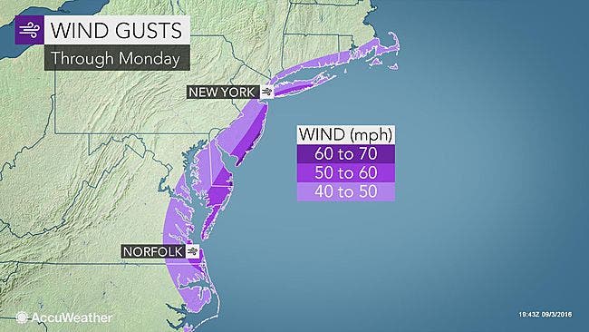
While the storm has officially lost tropical characteristics, it will maintain tropical storm strength and act like a slow-moving, powerful nor'easter. Winds offshore are expected to reach hurricane force from Saturday evening to Monday, according to an AccuWeather release.
How close to the coast Hermine tracks and where the storm stalls from Sunday onward will determine the severity and location of flooding and damaging winds. Even a small shift in the track can have a big difference on impacts, according to the release.
Latest indications keep the strongest winds and heaviest rain of Hermine offshore on Saturday night and beyond. Coastal areas of the mid-Atlantic and southern New England should still brace for extremely rough surf, strong winds and locally heavy rain, according to AccuWeather.
Tropical Storm Hermine battered the North Carolina coast on Saturday. But as it moves over the sea, just east of New Jersey, the storm could become a category 1 hurricane as it travels across warm water, forecasters say.
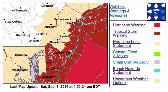
The National Weather Service subsequently declared a hurricane warning a few miles off the shore, but pulled it farther into the Atlantic Ocean later in the day.
:
The storm appeared to be moving further east, however, so the hurricane warning was pulled farther eastward:
To give you an idea how close this storm still is. Here is the latest NAM just out. pic.twitter.com/vW6pl9s8eu
— NY NJ PA Weather (@nynjpaweather) September 4, 2016
The hurricane warning came after the National Weather Service meteorologists determined that a warm front would settle in through Sunday, and Hermine would develop hurricane-force winds exceeding 7o mph.
Christie declared a state of emergency Saturday afternoon in three New Jersey counties — Ocean, Atlantic and Cape May — as much of the state remains under a tropical storm warning with Hermine moving north.
Christie said he declared the state of emergency because of the long holiday weekend, saying he wanted to maintain a "maximum amount of flexibility" in case the National Guard needed to be mobilized.
Several beaches in some towns, such as Brick, have closed. Other towns, such as Barnegat, have called for voluntary evacuations.
The Barnegat Police Department and Barnegat Office of Emergency Management are recommending that lagoon and bayfront area residents whose homes and properties are susceptible to flooding from nor'easters and tropical systems voluntarily evacuate prior to Sunday afternoon.
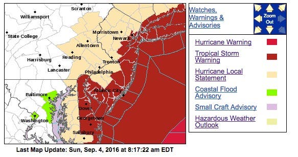
A tropical storm warning is now in effect for seven New Jersey counties: Monmouth, Ocean, eastern Burlington, Atlantic, Cape May, Cumberland and Salem, according to the National Weather Service.
A tropical storm watch is in effect for Essex, Hudson and Middlesex counties according to the National Weather Service. A hazardous weather outlook has been issued for the rest of the state as winds moving at a speed of 30 mph or more were expected to impact New Jersey.
Surfline provides a steady stream of video of the Ocean City boardwalk, and the effects of the storm were already apparent Saturday afternoon. Just refresh the page to keep the video running:
Here is one forecaster who believes the tide will be comparable to Sandy:
Atlantic City tidal forecast: Record is 9.0 feet from Dec. '92 Nor'easter. Sandy was 8.8ft. Forecast here: 8.8 ft. pic.twitter.com/oRtUQWi37k
— Dan Skeldon (@ACPressSkeldon) September 3, 2016
The following impacts are likely to occur:
- Sustained tropical storm-force winds are possible over immediate coastal areas including coastal waters and toward the lower Delaware Bay. Some tropical storm-force gusts are possible farther inland.
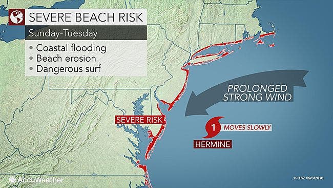
- Hazardous seas and dangerously rough surf can be expected through the holiday weekend and possibly into the middle of next week.
- A moderate to high rip current risk can be expected at the beaches during this time. Minor to moderate coastal flooding is possible around the times of high tide from late Saturday onward.
- Prepare for locally hazardous surge having possible limited impacts across coastal locations or areas prone to tidal flooding, including the back bays. potential impacts in this area.
- Moderate beach erosion is expected. Heavy surf will also breach dunes, mainly in usually vulnerable locations.
- Strong rip currents are anticipated. Minor to locally moderate damage to marinas, docks, boardwalks, and piers is possible. A few small craft may be broken away from moorings.
- Prepare for dangerous wind having possible significant impacts across New Jersey and southeastern Pennsylvania and northeast Maryland.
- Some damage to roofing and siding is likely, along with damage to porches, awnings, carports, and sheds.
- A few buildings will experience window, door, and garage door failures. Mobile homes may be damaged, especially if unanchored.
- Several large trees may be snapped or uprooted. several fences and roadway signs could be blown over.
- Some roads may be impassable from large debris. A few bridges, causeways, and access routes may be impassable.
- There could be scattered power and communications outages, but they will be more prevalent in areas with above ground lines.
- Evacuations: Now is the time to check your emergency plan and take necessary actions to secure your home or business. deliberate efforts should be underway to protect life and property. ensure that your emergency supplies kit is stocked and ready.
Photo: Surfline and NJBeachCams.com
Get more local news delivered straight to your inbox. Sign up for free Patch newsletters and alerts.