Weather
N.J. Weather: Winter Weather Advisory, Snow And Coastal Storm Expected
Expect a messy Friday commute and possible school closings or delayed openings. Here's how much you could get.

Expect several inches of snow — or just a wintry mess — when you wake up Friday morning. And expect your Friday commute to be a struggle, and possible school delays and closings along with it.
The National Weather Service has issued a winter weather advisory for all New Jersey counties north of Monmouth and Mercer counties — and a hazardous weather outlook for the rest of the state — as accumulating snow is expected to arrive.
Find out what's happening in Toms Riverfor free with the latest updates from Patch.
The winter weather advisory is in effect from midnight to noon Friday. Here are the affected areas:

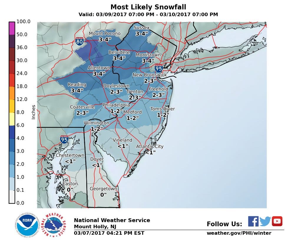
Here is what the National Weather Service is saying:
Find out what's happening in Toms Riverfor free with the latest updates from Patch.
- HAZARD TYPES...Snow in northern and central New Jersey, rain and snow to the south.
- SNOW ACCUMULATIONS... up to 2 to 4 inches, but closer to an inch in the south.
- TIMING...Rain will overspread the area and start to mix in with snow from north to south overnight tonight, between midnight and noon Friday. A changeover to all snow will also occur from north to south within a few hours after the rain starts. The snow will become moderate to briefly heavy at times late tonight and into the start of the Friday morning commute before gradually tapering off toward midday.
- IMPACTS...Local untreated roads will become snow covered and slippery, especially at higher elevations along and north of I-78. Poor visibility in heavier snow could also impact driving. Conditions will result in hazardous travel for the Friday morning commute.
- WINDS...North 5 to 10 mph in North and Central Jersey, but the Jersey Shore could get gusts up to 30 mph.
- TEMPERATURES...Upper 30s and lower 40s at the onset, then quickly falling into the lower and mid 30s overnight.
- VISIBILITIES...One-half mile or less at times.
- PRECAUTIONARY/PREPAREDNESS ACTIONS...A winter weather advisory for snow means that periods of snow will cause primarily travel difficulties. Be prepared for snow covered roads and limited visibilities...and use caution while driving.
Here is the forecast for the state:
- Thursday: Sunny, with a high near 60. West wind 10 to 18 mph, with gusts as high as 30 mph.
- Thursday night: A chance of rain before 3am, then rain and snow likely between 3am and 4am, then snow after 4 a.m. Low around 31. West wind 5 to 8 mph becoming northeast after midnight. Chance of precipitation is 80 percent. New snow accumulation of less than one inch possible.
- Friday: Snow, mainly before 11 a.m., then a chance of snow showers after 1 p.m. High near 39. Northeast wind 9 to 14 mph becoming northwest in the afternoon. Winds could gust as high as 24 mph. Chance of precipitation is 80 percent. New snow accumulation of 1 to 3 inches possible.
- Friday night: Partly cloudy, with a low around 20. Northwest wind around 16 mph.
Patch file photo
Get more local news delivered straight to your inbox. Sign up for free Patch newsletters and alerts.


