Weather
Tornado In NJ As More Than 19K Lost Power (VIDEO)
UPDATE: A tornado hit New Jersey on Wednesday, and a video shows what happened. Storms with damaging winds and power outages were reported


A tornado touched down in New Jersey as bad weather continued to hit parts of the state. More than 19,000 were without power during the afternoon and early evening (see list of towns below).
The National Weather Service confirmed with Union County Emergency Management that a brief tornado touched down near Springfield Avenue and Route 22 in Springfield. Radar-estimated winds were 70 mph.
Here are videos of the twister and the damage it left:
Find out what's happening in Toms Riverfor free with the latest updates from Patch.
TORNADO IN NJ: A tornado touched down in Springfield, New Jersey, the National Weather Service confirmed. Video shows what appears to be a funnel forming over a busy roadway, tossing debris into the air. https://t.co/3n0pdekccT pic.twitter.com/1dcAX0L8ow
— Eyewitness News (@ABC7NY) August 7, 2019
Confirmed tornado in Springfield, NJ. This is the parking lot off RT22 where it hit. @NWS says it was on the ground for no more than 4 minutes, about 70mph, around 2:47pm. Story tonight at 11pm on @ABC7NY pic.twitter.com/gUWRXQWjmG
— CeFaan Kim (@CeFaanKim) August 7, 2019
Exclusive NEW video of the #Springfield tornado ... hear from 11 year old boy who shot it on News 4 at 6pm #nbc4ny https://t.co/X5JNo7jgLX pic.twitter.com/6jclk48jYN
— Steven Bognar (@Bogs4NY) August 7, 2019
Some of the damage reported by the #Springfield tornado. Pics by @ChrisKeatingNJ Full story: https://t.co/R9SyG1qw2C pic.twitter.com/ix86XIq43R
— News12NJ (@News12NJ) August 7, 2019
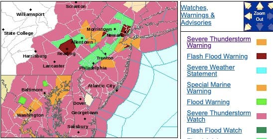
A severe thunderstorm watch was issued statewide until 9 p.m., according to the National Weather Service. A severe thunderstorm warning is issued when the storm threat is more imminent.
A severe thunderstorm was located over several counties throughout the afternoon. Lightning, 60-mph wind gusts and quarter-size hail were being reported (see map below).
Find out what's happening in Toms Riverfor free with the latest updates from Patch.
Minor damage to vehicles was possible. Wind damage to roofs, siding, trees and power lines was possible.
Here were the alerted areas as of 6:30 p.m.:

Here were the alerted areas as of 4:30 p.m.:
After storms hit Wednesday, more than 19,000 lost power in these New Jersey towns:
- KEARNY TOWN 2,707
- TOMS RIVER TOWNSHIP 1,892
- WEST ORANGE TWP 1,157
- SPRINGFIELD TOWNSHIP 1,026
- NORTH ARLINGTON BORO 1,003
- LIVINGSTON TWP 934
- EAST HANOVER TOWNSHIP 911
- JACKSON TOWNSHIP 815
- MEDFORD TWP 625
- MANSFIELD TWP 564
- NEW PROVIDENCE BOROUGH 552
- MARLBORO TOWNSHIP 548
- MIDDLETOWN TOWNSHIP 521
- Tabernacle Twp 461
- LITTLE FERRY BORO 424
- KEANSBURG BOROUGH 391
- BLOOMFIELD TWP 345
- FLORENCE TWP 278
- NORTH CALDWELL BORO 241
- DENVILLE TOWNSHIP 222
- TEWKSBURY TOWNSHIP 215
- NEWARK CITY 213
- ALEXANDRIA TOWNSHIP 193
- HANOVER TOWNSHIP 181
- Southampton Twp 167
- SOUTH ORANGE VILLAGE TWP 156
- PRINCETON 152
- LEONIA BORO 143
- FRANKLIN TWP 140
- BETHLEHEM TOWNSHIP 136
- FAIRFIELD TWP 128
- MOUNT LAUREL TWP 127
- Hopewell Twp 113
- PARSIPPANY TROY HILLS TOWNSHIP 106
- UNION TOWNSHIP 102
- LINCOLN PARK BOROUGH 98
- MOUNTAINSIDE BOROUGH 85
- PHILLIPSBURG TOWN 77
- EAST ORANGE CITY 68
- CLINTON TOWNSHIP 67
- COLTS NECK TOWNSHIP 66
- PEAPACK AND GLADSTONE BOROUGH 61
- FREDON TOWNSHIP 58
- WOODBRIDGE TWP 55
- HOWELL TOWNSHIP 46
- HARDING TOWNSHIP 46
- HOLLAND TOWNSHIP 44
- FRELINGHUYSEN TOWNSHIP 43
- EAST WINDSOR TOWNSHIP 41
- Woodland Twp 41
- UNION BEACH BOROUGH 38
- EDISON TWP 37
- ELIZABETH CITY 36
- BERNARDSVILLE BOROUGH 34
- CEDAR GROVE TWP 33
- BERKELEY TOWNSHIP 21
- STILLWATER TOWNSHIP 21
- MONTVILLE TOWNSHIP 20
- MANCHESTER TOWNSHIP 19
- FREEHOLD TOWNSHIP 16
- HAZLET TOWNSHIP 15
- HADDONFIELD BORO 14
- WEST WINDSOR TOWNSHIP 13
- BERNARDS TOWNSHIP 13
- Monroe Twp 11
- LEBANON TOWNSHIP 10
- MAPLEWOOD TWP 10
- LAKEWOOD TOWNSHIP 9
- GLEN RIDGE BORO 8
- VERONA TWP 7
- FRANKLIN TOWNSHIP 6
- BORDENTOWN TWP 6
- CRANFORD TWP 6
- LONG HILL TOWNSHIP 5
- BELLEVILLE TWP 5
- UNION TWP 5
A flash flood watch was issued for several counties in North, Central and South Jersey. Showers and thunderstorms were expected to develop early Wednesday afternoon and continue at times through the afternoon and early evening.
Terrible flooding under the Pulaski Skyway in Jersey City as storms strafe New Jersey. Thanks to @JOHNLHEW on Instagram for the video. How bad is it where you are? #njwx pic.twitter.com/ncoH7LcQNr
— NJ.com (@njdotcom) August 7, 2019
Periods of heavy rain were expected with areas of 1 to 2 inches, with local amounts of 3 to 4 inches possible. Heavy rainfall falling in a short amount of time could lead to flash flooding.
F-0 tornado in Springfield, NJ pic.twitter.com/ykH5QfREwB
— peter85 (@petew77) August 7, 2019
Pic of the damage from a confirmed EF0 tornado at the intersection of Springfield Ave and Rt 22 in Springfield NJ (photo credit: Stu Rosenthal); @wcbs880; @CraigAllenWx; @wcbs880traffic pic.twitter.com/1s38BDl75c
— Tom Kaminski (@TomKaminskiWCBS) August 7, 2019
The National Weather Service initially issued a hazardous weather outlook, saying widespread showers and thunderstorms were expected to develop Wednesday afternoon and evening. Some storms were expected to produce damaging wind gusts and localized flash flooding, the NWS says.
Here is what to expect:
.jpeg)
Here is when you should expect the worst:
- The heavy and thunder and lightning was expected to be at their worst after 3 p.m.
- The winds could be powerful enough to knock down power lines and flood roads.
The weather already had an impact since some storms hit New Jersey on Tuesday and early Wednesday. A water spout was spotted off the coast.
WATERSPOUT TODAY.... Just off the coast of Fortescue NJ around 7am. Tim Reeves was out on his commerical oyster boat and captured this amazing image. pic.twitter.com/6nhcUGds6E
— Adam Joseph (@6abcadamjoseph) August 6, 2019
Nearly 2,000 Atlantic City Electric customers were without power Tuesday afternoon after lightning struck a utility pole and energy infrastructure in Mays Landing, according to The Press of Atlantic City.
On Wednesday, heavy, gusty and locally severe storms will precede a push of cooler and less humid air across the Northeast this week, according AccuWeather.
Severe weather threat more likely later today - tonight. Main impacts include damaging winds, hail, heavy rainfall, & localized flash flooding. However, a tornado or two is not entirely out of the question well north of NYC. #NBC4NY pic.twitter.com/A1Z42PI3sb
— Storm Team 4 NY (@StormTeam4NY) August 7, 2019
Motorists and airline passengers should anticipate substantial delays for the afternoon and evening commute this day along the Interstate 95 corridor.
For those spending time at the beach this week, storms related to the cool front are most likely from Cape Cod, Massachusetts, to Long Island, New York, New Jersey, Maryland and the Virginia capes from late Wednesday to Thursday, according to AccuWeather.
.png)
Here is the forecast:
- Wednesday: Showers and thunderstorms, mainly after 2pm. Some of the storms could produce gusty winds and heavy rain. High near 86. Light south wind becoming southwest 5 to 10 mph in the morning. Chance of precipitation is 80%. New rainfall amounts between a quarter and half of an inch possible.
- Wednesday night: Showers and thunderstorms, mainly before 11pm. Some of the storms could produce gusty winds and heavy rain. Low around 67. Light southwest wind. Chance of precipitation is 80%. New rainfall amounts between a half and three quarters of an inch possible.
- Thursday: A chance of showers and thunderstorms, mainly before 3pm. Partly sunny, with a high near 86. Calm wind becoming west around 6 mph in the afternoon. Chance of precipitation is 30%. New rainfall amounts of less than a tenth of an inch, except higher amounts possible in thunderstorms.
- Thursday night: A slight chance of showers and thunderstorms before 2am. Partly cloudy, with a low around 67. West wind 3 to 5 mph. Chance of precipitation is 20%.
- Friday: Sunny, with a high near 83. Northwest wind 5 to 9 mph.
Get more local news delivered straight to your inbox. Sign up for free Patch newsletters and alerts.