Weather
Winter Storm Warning Issued In New Jersey: Snow Threat Increases
A winter storm warning was issued in New Jersey as the state could experience its most intense winter weather of the season.


UPDATE: The winter storm watch has been upgraded. Read more: N.J. Snow Threat Upgraded Again: Winter Storm Warning Issued
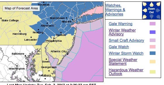
ORIGINAL STORY: The National Weather Service has issued a winter storm watch for most of New Jersey, upgrading the snow threat for the state where as many 6 inches could fall.
The NWS has issued a winter storm watch for all counties from northern Monmouth and Mercer to the north. The warning will be in effect from 6 p.m. Wednesday until 6 p.m. Thursday.
Find out what's happening in Toms Riverfor free with the latest updates from Patch.
A hazardous weather outlook has been issued for the rest of the state, where 2 to 4 inches are expected to fall. Either way, it could be the most intense winter weather system of the season to hit New Jersey this year.
Here is what the National Weather Service is predicting for northern Monmouth, Mercer County and north:
Find out what's happening in Toms Riverfor free with the latest updates from Patch.
- SNOW ACCUMULATIONS...Potential for 6 or more inches.
- TIMING...A wintry mix will overspread the area from the west Wednesday night. The event will likely begin as snow north of the I-78 corridor. Elsewhere, rain will change over to snow from northwest to southeast late Wednesday night into Thursday morning. Sleet may mix briefly during the transition from rain to snow. The snow could be heavy at times late Wednesday night and Thursday morning before tapering off from west to east during the afternoon Thursday.
- IMPACTS...The heavy snow and poor visibilities at times could make travel dangerous. Significant impacts to the Thursday morning rush are likely.
- WINDS...North 10 to 20 mph with gusts up to 30 mph.
- TEMPERATURES...Upper 30s and lower 40s at the onset, falling into the lower 30s by early Thursday morning.
- VISIBILITIES...1/2 mile or less at times in heavy snow.
The NWS says the bulk of the snowfall should arrive between 5 a.m. and 5 p.m. Thursday and the potential exists for "heavier amounts."
"Slippery travel is likely with a good chance of plowable amounts," according to the NWS alert.
The system will come after temperatures could hit as high as 60 degrees on Tuesday. But AccuWeather says temperatures will plunge 15 to 30 degrees from the Midwest to the interior South and northeastern United States during Wednesday night and into Thursday morning.
The storm will begin with a brief period of rain in most areas but will quickly change over to snow as temperatures plummet, according to AccuWeather.
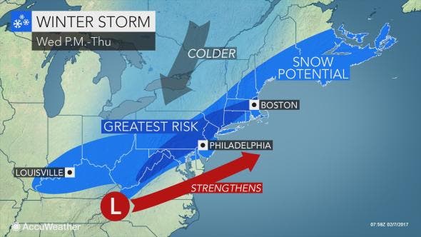
Despite the warmth into midweek, there is the potential for snow to fall at a fast enough pace to lead to slippery roads and airline delays as the storm progresses, according to AccuWeather.
By Thursday morning, temperatures will be within a few degrees of freezing in a large swath of the mid-Atlantic states. This will allow snow to begin to accumulate on the roadways, according to AccuWeather. The exact track of the storm will determine where the swath of heaviest snow occurs.
"The swath of accumulating snow is likely to be orientated in a narrow southwest to northeast band with the challenge being exactly where that band sets up," AccuWeather Senior Meteorologist Brian Wimer said in a release.
Here is the forecast:
- Tuesday: Periods of rain, mainly before 4pm. High near 54. Calm wind becoming southeast around 5 mph. Chance of precipitation is 100%. New precipitation amounts between a tenth and quarter of an inch possible.
- Tuesday night: A chance of rain before 7pm, then scattered showers, mainly between 7pm and 5am. Cloudy, with a low around 50. Southwest wind 7 to 15 mph. Chance of precipitation is 40%. New precipitation amounts of less than a tenth of an inch possible.
- Wednesday: Isolated showers after 1pm. Mostly cloudy, with a high near 62. Southwest wind 10 to 14 mph becoming northwest in the afternoon. Chance of precipitation is 20%.
- Wednesday night: Rain before 4am, then rain and snow. Low around 32. Northwest wind 7 to 13 mph becoming northeast after midnight. Chance of precipitation is 90%. New snow accumulation of less than one inch possible.
- Thursday: Snow, mainly before noon. High near 32. Breezy, with a north wind 15 to 21 mph. Chance of precipitation is 90%. New snow accumulation of 2 to 4 inches possible.
- Thursday night: A slight chance of snow before 1am. Partly cloudy, with a low around 18. Blustery. Chance of precipitation is 20%.
Patch file photo
Get more local news delivered straight to your inbox. Sign up for free Patch newsletters and alerts.


