Weather
Weekend Snow Threat Increases In NJ
Forecasters say we could get more inches than originally thought.


UPDATE: The National Weather Service has issued a winter storm watch for South Jersey and a winter weather advisory for North Jersey. Forecasted inch counts for South Jersey have increased to 3-6 inches.More information to come. Read more here...
ORIGINAL STORY: It's beginning to look like a bigger snowstorm than imagined is heading toward New Jersey.
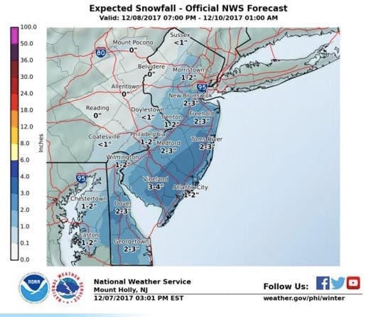
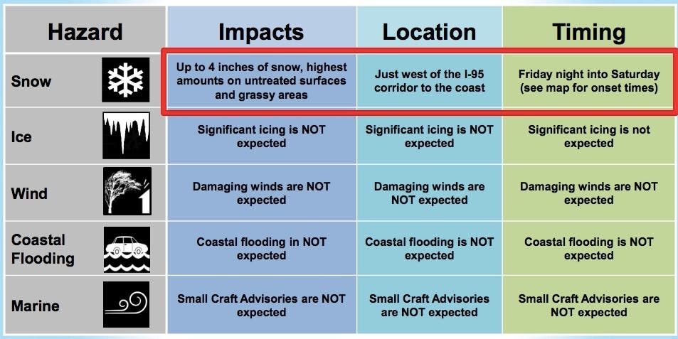
The National Weather Service has issued a hazardous weather outlook since 4 inches of snow could accumulate in parts of southern New Jersey, Central Jersey and the Jersey Shore this weekend. The rest of the state could get an inch or two.
Find out what's happening in Toms Riverfor free with the latest updates from Patch.
The first snow could start falling between 7 p.m. Friday and 1 a.m. Saturday in New Jersey, mostly impacting Ocean, Burlington, Atlantic, Cumberland and Cape May counties. But the entire state is expected to be impacted.
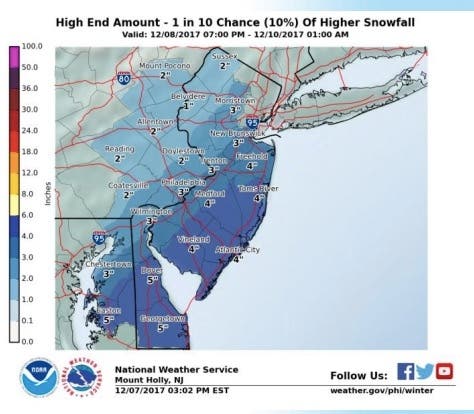
The National Weather Service also offered a worst-case scenario for all parts of New Jersey:
Find out what's happening in Toms Riverfor free with the latest updates from Patch.
The snow is expected to fall on-and-off on Saturday, and possibly keep going Saturday night and early Sunday morning, according to the National Weather Service.
Here is the forecast for the weekend:
- Thursday night: Increasing clouds, with a low around 28. West wind 6 to 9 mph.
- Friday: A slight chance of rain after 4 p.m. Mostly cloudy, with a high near 41. West wind 5 to 7 mph. Chance of precipitation is 20 percent.
- Friday night: A slight chance of rain and snow before 8 p.m., then a chance of snow. Cloudy, with a low around 30. Light and variable wind. Chance of precipitation is 50 percent. New snow accumulation of less than a half inch possible.
- Saturday: Snow likely before 1 p.m., then rain and snow likely between 1 p.m. and 2 p.m., then snow likely after 2pm. Mostly cloudy, with a high near 37. North wind 3 to 5 mph. Chance of precipitation is 70 percent. New snow accumulation of 2 to 4 inches possible.
- Saturday night: Snow likely before 1 a.m. Mostly cloudy, with a low around 27. Light northwest wind becoming west 5 to 10 mph in the evening. Chance of precipitation is 60 percent. New snow accumulation of less than a half inch possible.
- Sunday: Mostly sunny, with a high near 39.
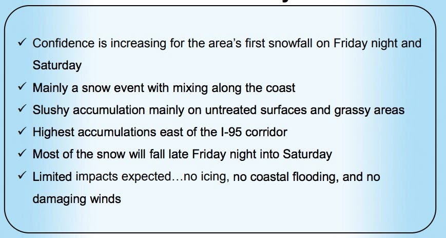
Image via Shutterstock.
Get more local news delivered straight to your inbox. Sign up for free Patch newsletters and alerts.


