Weather
Winter Weather Advisory In 14 NJ Counties As Polar Vortex Looms
UPDATED: A winter weather advisory has been expanded to 14 NJ counties as the weakening Polar Vortex is expected to make winter worse.


The first sign of New Jersey's worsening winter weather appeared early Tuesday as the region begins to deal with the impact of the weakening Polar Vortex.
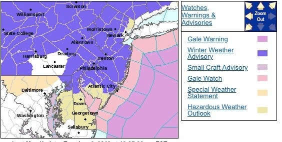
A winter weather advisory was expanded to 14 New Jersey counties – and set to expire at 7 a.m. Tuesday – as mixed precipitation was falling in the area and impacting the morning commute. Total snow accumulations of up to 1 inch and ice accumulations of a light glaze were expected, according to the National Weather Service.
The weather impacted school schedules on Tuesday. Read more: New Jersey School Closings/Delayed Opening List For 1/8/19
Find out what's happening in Toms Riverfor free with the latest updates from Patch.
Here is the scene in the Morris and Sussex County area:
Sleet mixing in now with the snow.. pic.twitter.com/AhMMuOQuJw
— Climate Detective (@NJSnowFan) January 8, 2019
The advisory had been issued for 19 counties – all except for Cape May and Cumberland – after the number was initially five. Overnight, the NWS reduced the advisory to 14 counties.
Find out what's happening in Toms Riverfor free with the latest updates from Patch.
Plan on slippery road conditions, especially during the Tuesday morning commute, according to the NWS.
At the very least, a wintry mix was expected to gradually transition to rain during the morning commute. Although accumulations were expected to be minimal, any ice can cause travel difficulties, the NWS sats.
Here are the alerted areas:
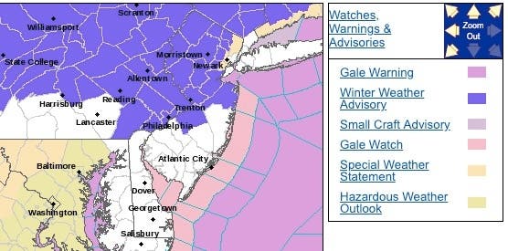
Here were the 19 counties initially under the advisory:
AccuWeather called this week's weather in New Jersey a "warning shot" for winter's return late in the month and early February. "A major stratospheric warming event has begun," according to AccuWeather Senior Meteorologist Brett Anderson.
When the stratosphere warms suddenly over the North Pole, it weakens the polar vortex and causes the normally pent-up frigid air to be displaced southward and into the New Jersey area, according to AccuWeather.
Arctic air, as a result, is likely to periodically brush areas from the Upper Midwest to the Northeast. The northern parts of these areas – including New Jersey – will likely receive rounds of snow, according to AccuWeather
During the latter part of January, temperatures may shift from generally at or above average to slightly or significantly below average in the Northeast as that cold air from the North Central states tries to work eastward, according to AccuWeather.
Substantial cold weather is still anticipated during February, according to AccuWeather. How severe and long-lasting the colder weather is may depend somewhat on the southward position of the polar vortex and the extent of snow on the ground.
-1546869398-1948.jpg)
Here is the forecast:
- Tuesday: Rain and sleet likely before 1pm, then a slight chance of rain after 5pm. Mostly cloudy, with a high near 49. Light southwest wind. Chance of precipitation is 60%. New sleet accumulation of less than a half inch possible.
- Tuesday night: Rain likely, mainly between 7pm and 1am. Mostly cloudy, with a low around 37. Light and variable wind becoming west 8 to 13 mph in the evening. Chance of precipitation is 70%. New precipitation amounts between a tenth and quarter of an inch possible.
- Wednesday: Partly sunny, with a high near 43. West wind 14 to 16 mph, with gusts as high as 31 mph.
Tom Davis photo
Get more local news delivered straight to your inbox. Sign up for free Patch newsletters and alerts.