Weather
Winter Storm Watch, Winter Weather Advisory In 21 NJ Counties
UPDATE: How much snow will fall? Here is what to expect as the snow and winter weather estimates have increased.


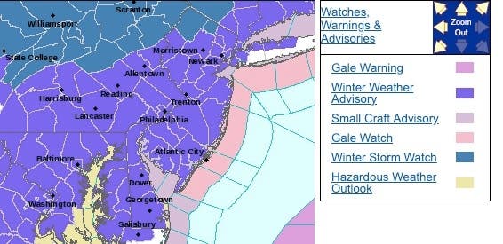
A winter storm watch has been issued for two counties, and a winter weather advisory has been issued for 19 counties, as New Jersey is bracing for snow over the next few days (see snow estimates below).
Mixed precipitation and total snow accumulations of up to 2 inches are expected, and ice accumulations of a light glaze are possible, over the next 24 hours, according to the National Weather Service. Then another system is supposed to come in an impact the area on Monday night and Tuesday.
The weather changed school schedules on Monday and Tuesday. Read more: New Jersey School Closings/Delays List For Monday And Tuesday.
Find out what's happening in Toms Riverfor free with the latest updates from Patch.
The winter storm watch is in effect for Sussex and Passaic counties. Heavy mixed precipitation is possibe, and total snow accumulations of 5 to 7 inches – as well as ice accumulations of up to one quarter of an inch – are possible.
The advisory is in effect in all other New Jersey counties, and it was issued for the Sunday-Monday morning system. Plan on slippery road conditions. The hazardous conditions will likely impact the Monday morning commute.
Find out what's happening in Toms Riverfor free with the latest updates from Patch.
Patch will have the snow totals. Read more: New Jersey Snow Totals, Town-By-Town, For Sunday Through Tuesday
Here are the impacted areas:
In both systems, some locations may receive a significant accumulation of snow and ice, especially in the elevated terrain. The wintry precipitation will likely affect the morning and evening commutes on Tuesday, according to NWS.
Here are the expected snow totals for the Sunday-Monday snow:
-1549808865-1458.jpg)
Here are the high-end predictions:
-1549808908-2032.jpg)
Here's what's predicted in all areas of the state:
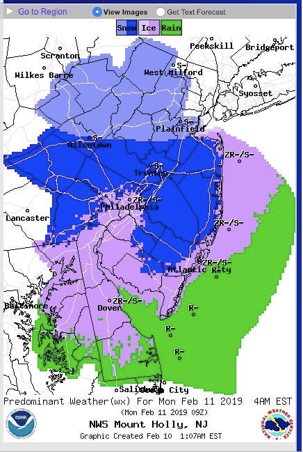
Monday, 4 a.m.:
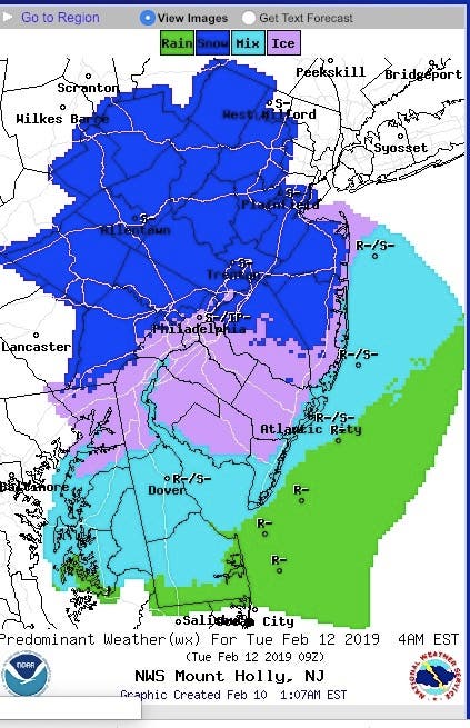
Tuesday, 4 a.m.:
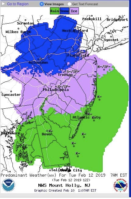
Tuesday, 7 a.m.:
Here is the forecast for the next few days:
- Monday: Snow likely before noon, then a chance of rain and snow. Mostly cloudy, with a high near 36. Northeast wind 3 to 8 mph. Chance of precipitation is 60%. New snow accumulation of less than a half inch possible.
- Monday night: Snow likely, mainly after 1am. Cloudy, with a low around 28. East wind 6 to 11 mph. Chance of precipitation is 60%. New snow accumulation of 1 to 2 inches possible.
- Tuesday: Rain and snow, possibly mixed with freezing rain and sleet before noon, then rain, possibly mixed with freezing rain and sleet between noon and 1pm, then rain after 1pm. High near 40. East wind 14 to 18 mph. Chance of precipitation is 90%. Little or no ice accumulation expected. New snow and sleet accumulation of 1 to 3 inches possible.
- Tuesday night: Rain. Low around 35. Chance of precipitation is 90%. New precipitation amounts between a half and three quarters of an inch possible.
Patch photo
Get more local news delivered straight to your inbox. Sign up for free Patch newsletters and alerts.


