Weather
Snow In Wayne: What To Expect As Nor'Easter Moves In
There's also an enhanced wind risk that could cause power outages, with some tree damage possible, along with snow accumulation.

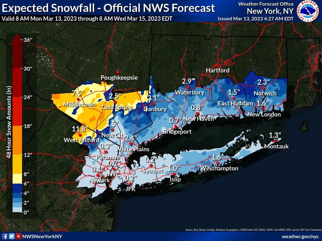
WAYNE, NJ — Gusty winds and wet snow could affect both the Tuesday morning and evening commutes in Wayne and bring up to 12 inches of snow in Passaic County, said forecasters.
Patch readers in Wayne won't see as much snow as readers further west in the county, who are under a Winter Storm Warning from the National Weather Service.
There’s also an enhanced wind risk that could cause power outages throughout the state, with some tree damage possible. Related article — Snow, Wind: How Incoming Nor'Easter Will Impact NJ
Find out what's happening in Waynefor free with the latest updates from Patch.
William Paterson University has closed campus for Tuesday, March 14 and will operate remotely.
A Winter Weather Advisory is in effect in eastern Passaic County from midnight on Tuesday morning to 6 a.m. Wednesday. The National Weather Service says total snow accumulations of two to five inches are expected in the eastern portion of the county, with winds gusting up to 40 miles per hour.
Find out what's happening in Waynefor free with the latest updates from Patch.
Elevations above 500 feet will have accumulations closer to five to seven inches, said the NWS.
And western Passaic County residents are under that Winter Storm Warning from 10 p.m. Monday until 6 a.m. Wednesday. Total snow accumulations between four to 12 inches are possible in this area, and also wind gusts up to 40 mph.
Higher amounts of eight to 12 inches are possible in elevations above 750 feet, said the NWS's New York office.
The track of the storm can significantly impact conditions in northern NJ, said AccuWeather: “Any slight shift could spell trouble for how much snow the region receives.”
Here is the forecast for eastern Passaic County from the National Weather Service.
Monday night
Rain. Low around 35. Northeast wind around 10 mph becoming north after midnight. Chance of precipitation is 100%. New precipitation amounts between 1 and 2 inches possible.
Tuesday
Rain and snow in the morning, then rain in the afternoon. Snow may be heavy at times in the morning. Snow accumulation up to 1 inch. Breezy. Near steady temperature in the mid 30s. Northwest winds 15 to 25 mph with gusts up to 35 mph. Chance of precipitation near 100 percent.
Tuesday night
Mostly cloudy. Rain with a chance of snow in the evening, then a chance of rain and snow after midnight. Little or no snow accumulation. Breezy with lows around 30. Northwest winds 20 to 25 mph with gusts up to 40 mph. Chance of precipitation 80 percent.
Get more local news delivered straight to your inbox. Sign up for free Patch newsletters and alerts.