Weather
Here's The Latest On How Hurricane Dorian Could Impact NJ
Here's the latest on how much of an impact Hurricane Dorian will have on New Jersey.


NEW JERSEY — Hurricane Dorian's tropical storm-force winds of 40 mph or more reached the Atlantic coast of Florida Monday evening, causing hurricane warnings and watches, along with storm surge alerts, to spread across the state. The slow-moving hurricane came to a virtual standstill about 105 miles off the coast.
What remains a mystery is how much of an impact Dorian will have on New Jersey since it's supposed to travel in a northeasterly direction while moving along the coast of the Southeast. It's path is expected to eventually bring it near New Jersey, possibly brushing off the coast (or possibly worse).
But the storm also could move to the west slightly, which would mean that Dorian would have a more direct impact on New Jersey.
Find out what's happening in West Windsorfor free with the latest updates from Patch.
Here's what's expected as of Sunday night:
- Forecasters agree that the storm, which currently packs wind gusts up to 190 mph and sustained winds of 150 mph, is already causing strong rip currents along the Jersey Shore that could only get worse by the end of the week.
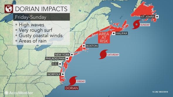
- Dorian's outermost wind bands could hit South Jersey and the Jersey Shore by late Thursday or Friday. Winds as strong as 40 mph and tropical-storm conditions could be felt in those areas even as the hurricane is expected to weaken by then.
- Dorian could behave similarly to a wintertime nor'easter, even if the center stays at sea, AccuWeather says. The rain shield with Dorian may generally impact areas along and east of the I-95 corridor."
![]()
- Locations from Norfolk, Virginia; Dover, Delaware; Atlantic City, New Jersey; Islip, New York; and Plymouth, Massachusetts, are some of the cities that could face a 12- to 24-hour period of soaking rain and gusty winds, according to AccuWeather.
- Part of New Jersey initially entered the National Hurricane Center's "cone of uncertainty," which forecasts all the possible areas that would feel the impact of the storm. But as of Monday, New Jersey had moved almost entirely out of that cone.
![]()
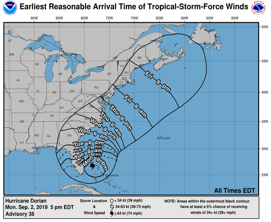
- New Jersey, however, remains in the storm's wind zone, which says the outerbands of the storm could arrive between 8 p.m. Thursday and 8 p.m. on Friday.
![]()
- A rip current statement also was issued for the entire Jersey Shore. Very strong rip currents will be dangerous, the National Weather Service said. Swim near a lifeguard; if caught in a rip current, relax and float.
- Officials in Cape May County and Long Beach Island were advising and urging people to stay out of the water. "Due to extremely dangerous rip currents, and numerous water rescues please stay out of the ocean. NO SWIMMING!" Long Beach Township officials told swimmers.
- Joe Miketta, warning coordination meteorologist for the National Weather Service in Mount Holly, told Patch that he doesn't expect the storm to hit New Jersey directly – thought part of Dorian's western edge could "brush" over the Jersey Shore. "We might just get a glancing blow," he said.
.png)
Patch is tracking every move of Hurricane Dorian. Get all the updates on the storm by subscribing to Patch's free breaking news alerts and daily newsletters.
Find out what's happening in West Windsorfor free with the latest updates from Patch.
Here's the forecast:
- Tuesday: Sunny, with a high near 81. North wind 5 to 7 mph becoming east in the afternoon.
- Tuesday night: Mostly clear, with a low around 65. Southeast wind around 6 mph.
- Wednesday: A slight chance of showers and thunderstorms after 2pm. Mostly sunny, with a high near 88. Southwest wind 9 to 15 mph. Chance of precipitation is 20%.
- Wednesday night: A chance of showers and thunderstorms. Mostly cloudy, with a low around 64. Southwest wind 5 to 9 mph becoming north after midnight. Chance of precipitation is 40%. New rainfall amounts of less than a tenth of an inch, except higher amounts possible in thunderstorms.
- Thursday: A chance of showers, with thunderstorms also possible after 2pm. Mostly cloudy, with a high near 72. Chance of precipitation is 30%. New rainfall amounts of less than a tenth of an inch, except higher amounts possible in thunderstorms.
- Thursday night: A chance of rain and thunderstorms. Mostly cloudy, with a low around 61. Chance of precipitation is 40%.
- Friday: A chance of rain. Mostly cloudy, with a high near 71. Breezy. Chance of precipitation is 50%.
Prepare Your Home
- Bring loose, lightweight objects such as patio furniture, garbage cans and bicycles inside.
- Anchor objects that would be unsafe to bring inside (e.g., gas grills and propane tanks).
- Trim or remove damaged trees and limbs close enough to fall on structures.
- Secure loose rain gutters and downspouts and clear any clogged areas or debris to prevent water damage to your property.
- Purchase a portable generator or install a whole-house generator for use during power outages.
- Keep alternative power sources, such as a portable generator, outside, at least 20 feet away from the house, and protected from moisture.
- Document the condition of your home prior to the storm.
How To Prepare
Contact an insurance agent or call the National Flood Insurance Program at 888.379.9531 or visit Floodsmart.gov purchase a flood insurance policy. Remember, it takes 30 days for a flood insurance policy to take effect, don’t wait till you see a storm coming to purchase a plan!
Get more local news delivered straight to your inbox. Sign up for free Patch newsletters and alerts.