Schools
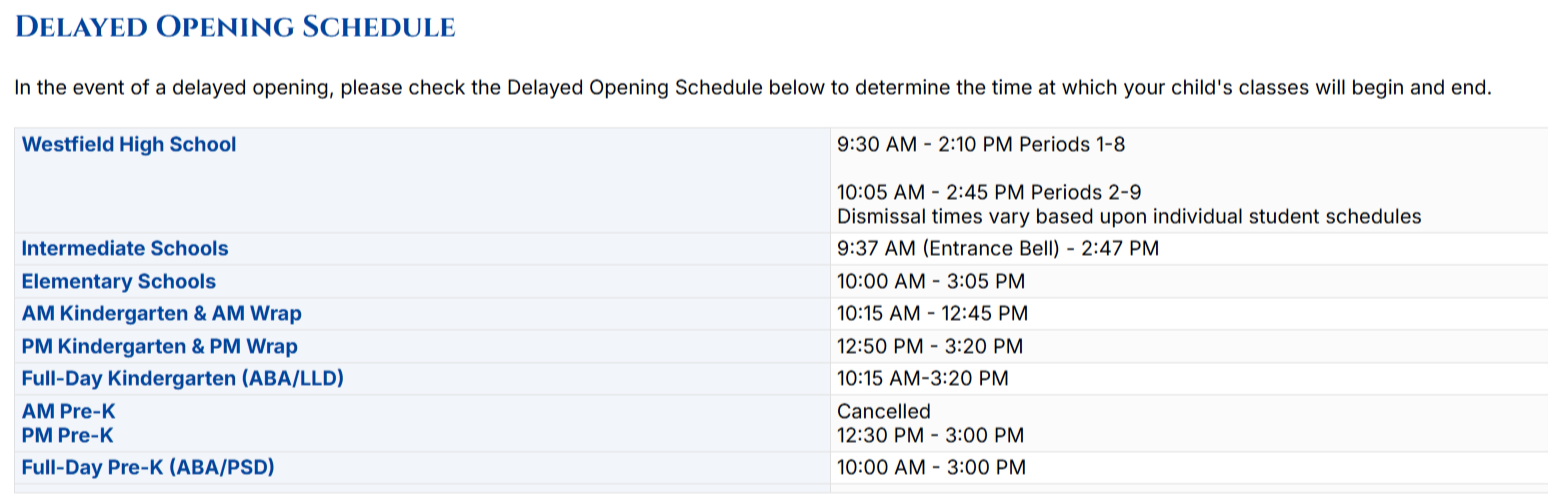
Delayed Opening For Westfield Schools Due To Winter Storm
Forecasters predict mixed precipitation overnight with a mix of rain, snow, sleet, and ice on Thursday morning.

WESTFIELD, NJ — All Westfield Public Schools will have a delayed opening on Thursday in anticipation of a winter storm.
"We want to provide ample advance notice as we take this necessary step to ensure the safety of our staff and students during their morning commute and to allow time for the DPW and our buildings and grounds crews to address icy conditions. Please travel safely!"
Forecasters predict mixed precipitation overnight with a mix of rain, snow, sleet and ice on Thursday morning. It will change to all rain after 11 a.m., according to the National Weather Service.
Find out what's happening in Westfieldfor free with the latest updates from Patch.
Here's the National Weather Service's latest forecast for Westfield:
Wednesday Night: Snow, mainly after 4 a.m. Low around 28. Calm wind becoming southeast around 6 mph after midnight. Chance of precipitation is 80 percent. Total nighttime snow accumulation of less than one inch possible.
Find out what's happening in Westfieldfor free with the latest updates from Patch.
Thursday: Rain, snow, freezing rain, and sleet before noon, then a chance of rain between noon and 3 p.m. High near 38. Wind chill values between 25 and 35. East wind 5 to 7 mph becoming northwest in the afternoon. Chance of precipitation is 100 percent. Little or no ice accumulation expected. New snow and sleet accumulation of less than one inch possible.
Thursday Night: Mostly cloudy, with a low around 34. Southwest wind 6 to 9 mph.
Friday: Mostly sunny, with a high near 41. West wind 10 to 15 mph, with gusts as high as 29 mph.
Friday Night: Partly cloudy, with a low around 24. West wind around 6 mph.
Have a news tip? Email alexis.tarrazi@patch.com.
Get more local news delivered straight to your inbox. Sign up for free Patch newsletters and alerts.