Home & Garden
Christmas Weather Outlook Issued For Westchester
Weather forecasters have issued an early outlook for the 2015 holiday season, as well as this weekend.

Written by TOM DAVIS (Patch Staff)
Are you dreaming of a white - or a warm - Christmas and holiday season?
AccuWeather has some predictions for New York that you may find surprising.
Find out what's happening in Bedford-Katonahfor free with the latest updates from Patch.
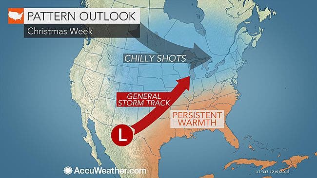
The overall pattern will favor temperatures averaging above normal in much of the central and eastern United States through at least Christmas, but the warmth will falter at times in some locations, according to an AccuWeather release.
“There is a universal yearning for cold and snow around Christmastime, especially in the Midwest and Northeast,” AccuWeather Chief Meteorologist Elliot Abrams said in the release.
Find out what's happening in Bedford-Katonahfor free with the latest updates from Patch.
Looks like those dreams will fall short. In fact, AccuWeather says the odds of snow chances are more likely to occur beginning in the middle of January, but February has a likelihood to be snowy.
So far this season, mild air has overwhelmed the Central and Eastern states. Temperatures have averaged several degrees above normal since October.
This overall mild pattern is expected to hold through at least the end of December and into the first part of the new year.
That warmer weather will be around in the immediate future as well.
Here is the Westchester weekend forecast:
Saturday: Mostly sunny. Highs around 60. West winds around 5 mph.
Saturday Night: Mostly cloudy. Patchy fog after midnight. Lows in the upper 40s. West winds around 5 mph.
Sunday: Partly sunny. Patchy fog in the morning. Highs in the lower 60s. West winds around 5 mph...becoming south in the afternoon.
Sunday Night: Mostly cloudy. Lows in the lower 50s.
The yearning for a snowy season could be intensified this Christmas. Despite a cold and snowy fall and winter last year in much of the Midwest and Northeast, warmth surged in before the holiday and spoiled the notion of a white Christmas for millions of people.
Highs were in the 40s in Chicago and Buffalo, New York, the 50s in St. Louis and Burlington, VT, and the 60s in Oklahoma City, New Jersey and New York City during Christmas Day 2014.
AccuWeather Chief Long Range Meteorologist Paul Pastelok said there will be several doses of chilly air that sweep across parts of the Central and Northeastern states from the middle of December to beyond Christmas.
Because of the marginal temperatures expected, timing of the storms will be very important for those hoping for a white Christmas.
“The problem will be for storms to catch up with the brief episodes of chilly air in absence of persistent and extensive cold conditions,” Pastelok said.
“A persistent storm track that has split chilly air to the northwest and mild air to the southeast should continue from the southern Rockies toward the Great Lakes through the end of December.”
A secondary storm track along the coastal Northeast could come into play for parts of northern New England and upstate New York, provided the secondary storms are strong enough to draw in cold air.
Factoring in that actual temperatures will continue to trend downward, following typical seasonal trends, air cold enough for snow may extend a bit farther to the south and east compared to November and early December this year and last Christmas.
Cities such as Chicago; Minneapolis; Kansas City, MO; Albany, NY; and Caribou, ME; may be cold enough for snow this Christmas, provided a storm is in the vicinity.
Even so, most areas from the southern Plains to the Ohio Valley, much of the mid-Atlantic and southeastern New England on south are looking at air too warm too often to support snow through Christmas.
More persistent winter weather for the Midwest and Northeast is still many weeks away, according to Pastelok.
“We expect some colder air masses and perhaps opportunities for snow to pick up toward the middle of January,” Pastelok said. “February should be busy in terms of cold air, storms and the potential for snow.”
Map via AccuWeather.com
Get more local news delivered straight to your inbox. Sign up for free Patch newsletters and alerts.