Home & Garden
'Biggest Chance for Significant Snow' for Harrison in the Forecast
A Hazardous Weather Outlook already has been issued for a storm that could hit the Hudson Valley by the end of the work week.

After a long weekend for most Westchester County residents, the work week will start cold and end cold. High temperatures will barely get into the 30s later in the week, according to accuweather.com.
Click here for Harrison’s in-depth weather forecast.
The National Weather Service already is looking toward the future and has issued a “Hazardous Weather Outlook” for Putnam, Rockland and Westchester counties for a storm that is in reality five days away.
Find out what's happening in Harrisonfor free with the latest updates from Patch.
The weather service’s statement is brief except to say, “THERE IS A CHANCE OF A WINTER STORM LATE FRIDAY THROUGH SATURDAY NIGHT.”
Here are some details, including the distinct possibility that it won’t materialize.
Find out what's happening in Harrisonfor free with the latest updates from Patch.
“The storm is projected to rapidly deepen over the southeast, and once it reaches the coast… rapidly intensify,” says Bill Potter of Hudson Valley Weather. “It should spread a large swath of moderate to heavy snow across part of the mid-atlantic and northeast. The exact track and speed of the storm will determine who sees the heaviest snow. Some of the solutions put the Hudson Valley in the bulls eye, and some keep the worst weather to our south. Clearly, at 5+ days away, we will be watching this closely.”
NBC Connecticut Meteorologist Ryan Hanrahan wrote on his blog, while stressing there is no guarantee that we’ll get hit with a major storm: “This is by far the biggest chance for significant snow we’ve had all season (though that’s not exactly saying much).”
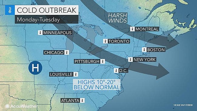
MAP: Accuweather.com
Get more local news delivered straight to your inbox. Sign up for free Patch newsletters and alerts.