Weather
Rain for Southern Westchester Thursday, But Watch Out if You're Driving North
The season's first wintry mix is forecast for northern Westchester, the rest of the Hudson Valley and western Connecticut.

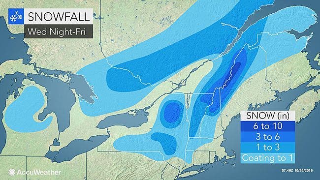
Rain is in the forecast for southern Westchester — but even though these communities will miss the season's first combo precipitation, leaf-covered roads could be slick during the morning commute.
Plus if you're driving elsewhere, know that the National Weather Service has issued a notice for Orange, Putnam, Rockland and northern Westchester to warn local travelers. The NWS says a light mixture of snow and sleet is expected to begin after midnight across Orange and Rockland and move east into Connecticut and north into western New England. There could be light accumulations by morning rush hour.
The rain could be heavy at times, even including some thunder, according to Hudson Valley Weather. That's good, because Westchester is still classified in severe drought.
Find out what's happening in Harrisonfor free with the latest updates from Patch.
Here's the NWS's immediate forecast for southern Westchester:
Tonight
Partly cloudy this evening...then mostly cloudy with a slight chance of rain after midnight. Lows in the mid 30s. Northeast winds around 5 mph. Chance of rain 20 percent.
Find out what's happening in Harrisonfor free with the latest updates from Patch.
Thursday
Rain. Highs in the upper 40s. East winds 10 to 15 mph. Chance of rain near 100 percent.
Thursday Night
Cloudy. Showers with isolated thunderstorms in the evening...then a chance of showers after midnight. Lows in the upper 40s. South winds 5 to 10 mph...becoming west 10 to 15 mph after midnight. Chance of rain 90 percent.
Friday
Mostly sunny. Highs in the mid 50s. Northwest winds 15 to 20 mph with gusts up to 30 mph.
Map/ AccuWeather.com
Get more local news delivered straight to your inbox. Sign up for free Patch newsletters and alerts.