Weather
‘Moderate To Heavy’ Rain Looms In Hudson Valley Weather Forecast, Here’s What To Know
Find out when wet weather will impact the region, and the latest forecast for the weekend, according to meteorologists.

HUDSON VALLEY, NY — Widespread rain is expected to fall in the Hudson Valley starting Wednesday night, according to the National Weather Service.
While today is starting out sunny and dry, clouds will gather as the day progresses, with temperatures reaching into the 60s.
“Rain develops this evening, and could fall moderate to heavy at times into the overnight. The rain tapers from west to east on Thursday,” the National Weather Service’s New York City office reports.
Find out what's happening in Mid Hudson Valleyfor free with the latest updates from Patch.
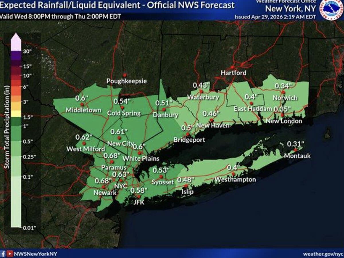
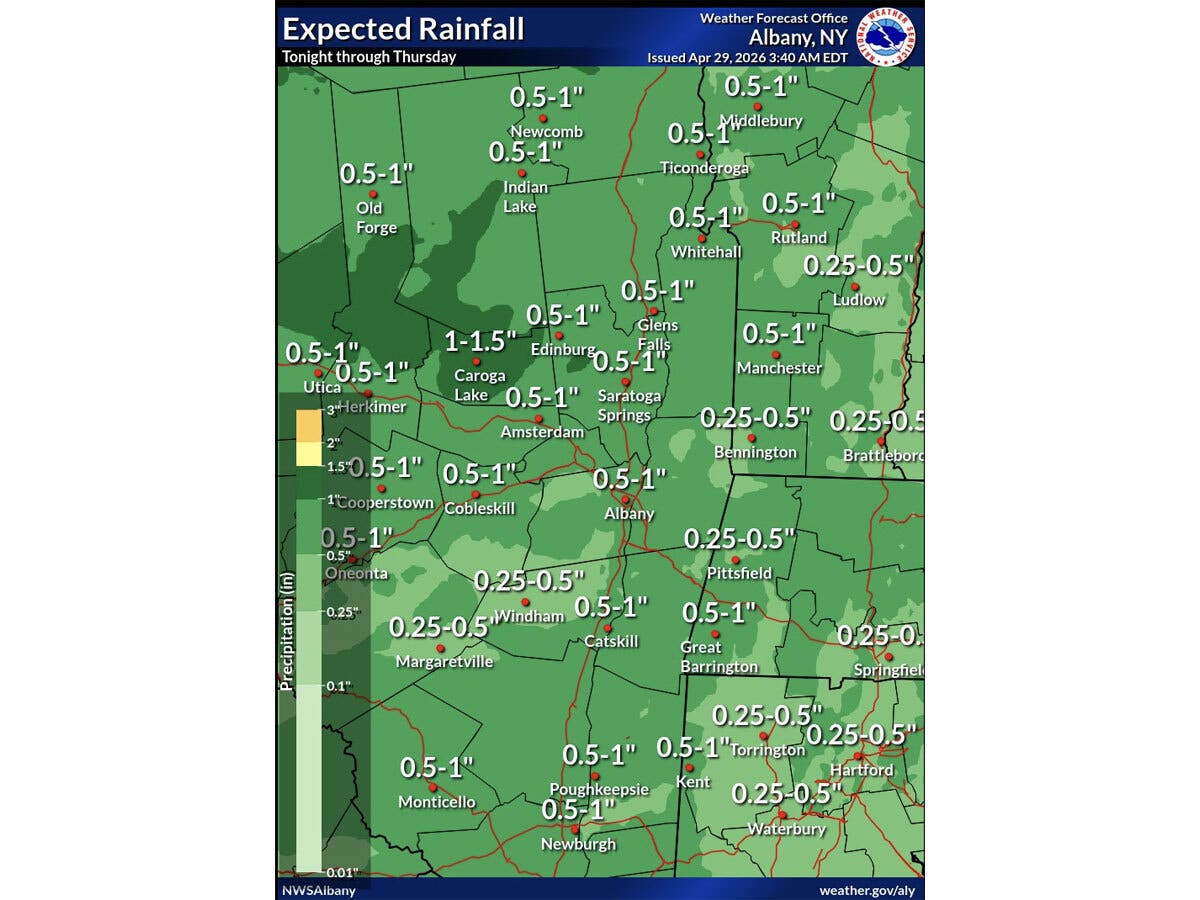
Its Albany office predicts rain will develop from west to east this evening into tonight, then gradually taper off on Thursday.
It predicts widespread amounts of mainly 0.50"-1.25" of rain, though it does not anticipate any flooding.
Find out what's happening in Mid Hudson Valleyfor free with the latest updates from Patch.
The rain is expected to start after 8 p.m. tonight, and taper off by 8 a.m. on Thursday, though there is a chance of showers into the early afternoon on Thursday, according to the National Weather Service.
Cooler temperatures will move into the region after the rain, with high temperatures Thursday through Sunday averaging in the upper 50s to around 60 degrees, the National Weather Service reports. The weekend is expected to be dry and sunny.
Here are the forecast details for the Mid-Hudson Valley area via the National Weather Service:
Today: Mostly cloudy, with a high near 68. Calm wind becoming south 5 to 7 mph in the afternoon.
Tonight: Rain, mainly after 8 p.m. Low around 47. South wind around 6 mph becoming calm in the evening. Chance of precipitation is 100%. New precipitation amounts between a quarter and half of an inch possible.
Thursday: Rain likely before 8 a.m., then a chance of showers between 8 a.m. and 2 p.m. Cloudy, then gradually becoming mostly sunny, with a high near 60. Calm wind becoming northwest 5 to 9 mph in the afternoon. Chance of precipitation is 60%. New precipitation amounts between a tenth and quarter of an inch possible.
Thursday Night: Mostly clear, with a low around 37. West wind 3 to 7 mph.
Friday: A slight chance of showers after 2 p.m. Mostly sunny, with a high near 59. West wind 6 to 10 mph, with gusts as high as 20 mph. Chance of precipitation is 20%.
Friday Night: Partly cloudy, with a low around 36.
Saturday: Partly sunny, with a high near 57.
Saturday Night: Mostly cloudy, with a low around 35.
Sunday: Mostly sunny, with a high near 57.
Here are the forecast details for the lower Hudson Valley area via the National Weather Service:
Today: Mostly cloudy, with a high near 63. South wind 5 to 9 mph.
Tonight: Showers. Low around 47. South wind around 6 mph. Chance of precipitation is 90%. New precipitation amounts between a quarter and half of an inch possible.
Thursday: Showers likely, mainly before 8 a.m. Cloudy, then gradually becoming mostly sunny, with a high near 62. Northwest wind 6 to 14 mph. Chance of precipitation is 60%. New precipitation amounts between a tenth and quarter of an inch possible.
Thursday Night: Mostly clear, with a low around 42. Northwest wind around 13 mph.
Friday: Sunny, with a high near 59. West wind 14 to 16 mph.
Friday Night: Partly cloudy, with a low around 41.
Saturday: Partly sunny, with a high near 56.
Saturday Night: Mostly cloudy, with a low around 40.
Sunday: Mostly sunny, with a high near 58.
Get more local news delivered straight to your inbox. Sign up for free Patch newsletters and alerts.