Weather
Nor’easter Expected To Bring First Snow Of Season To Parts Of Hudson Valley
Find out the latest timeline for the incoming storm system.


HUDSON VALLEY, NY — A storm system will soon bring widespread rain to the Hudson Valley, while some northern areas of the region could expect some snow mixed in, according to meteorologists.
The National Weather Service’s Albany office reports the precipitation timeline is between late Wednesday through Friday.
It predicts a mostly rain event at lower elevations and in the southern and mid Hudson Valley.
Find out what's happening in Mid Hudson Valleyfor free with the latest updates from Patch.
The National Weather Service’s Weather Prediction Center reports the system will bring the first accumulating snow to the interior Northeast.
“Precipitation will mostly fall as rain in the low elevations, but some wet snow could briefly mix in at times as colder air wraps in behind the storm,” it reported.
Find out what's happening in Mid Hudson Valleyfor free with the latest updates from Patch.
By late Thursday and Friday, precipitation is expected to become a mix of rain and snow, with a change to wet snow across higher elevations, according to the National Weather Service.
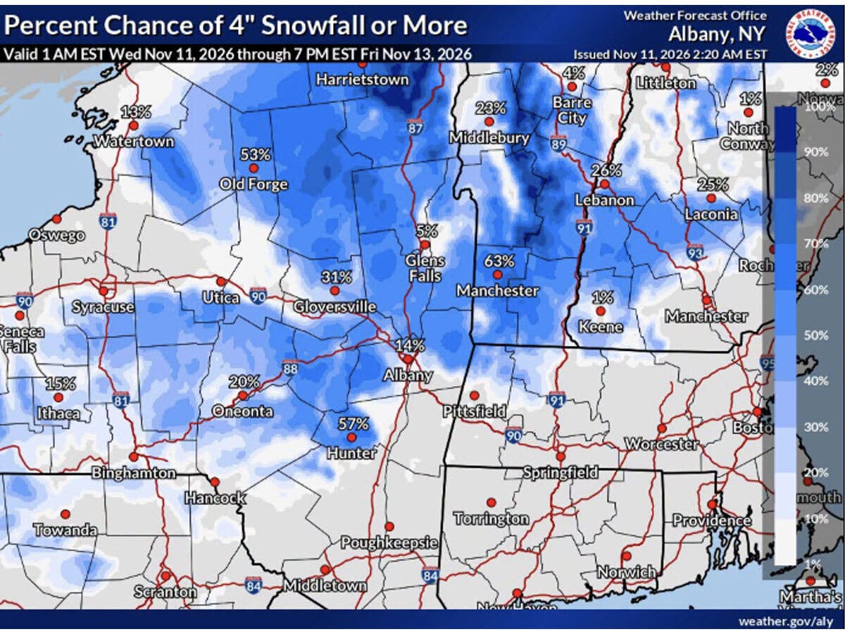
“Some of the valley areas could receive a coating to an inch or so of snow especially on the grassy surfaces,” the National Weather Service reports. “The chances for > 1" of snow accumulation have increased for the Capital District, Mohawk Valley and the Upper Hudson Valley.”
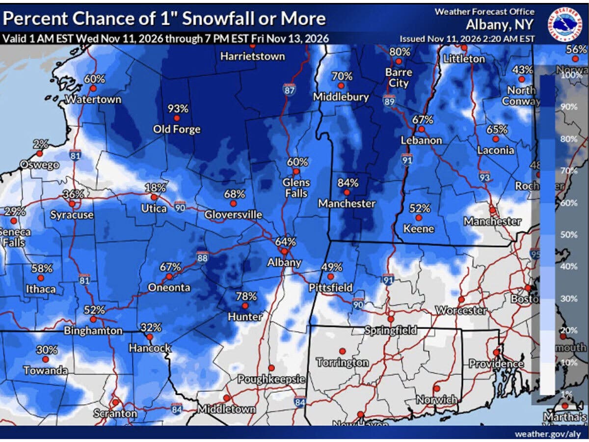
The Weather Channel is calling the storm a “nor’easter” which could bring the first accumulating snow of the season for the interior Northeast. It predicts rain starts on Thursday, continues Friday, and lingers into early Saturday, with wet snow in the “hilly interior” from late Thursday into Friday.
The National Weather Service predicts any precipitation will end by Saturday morning in the Hudson Valley. The remainder of the weekend is expected to be dry and cooler, with daytime highs in the upper 40s to low 50s.
Here are the forecast details for the Mid-Hudson Valley area via the National Weather Service:
Veterans Day: Partly sunny, with a high near 60. Light west wind.
Tonight: A chance of rain, mainly after 4 a.m. Mostly cloudy, with a low around 40. Calm wind. Chance of precipitation is 40%. New precipitation amounts of less than a tenth of an inch possible.
Thursday: Rain, mainly after noon. High near 52. Northeast wind 3 to 7 mph. Chance of precipitation is 100%. New precipitation amounts between a quarter and half of an inch possible.
Thursday Night: Rain. Low around 36. North wind 6 to 8 mph, with gusts as high as 21 mph. Chance of precipitation is 100%. New precipitation amounts between a quarter and half of an inch possible.
Friday: Rain, mainly before 1 p.m. High near 45. North wind 8 to 10 mph, with gusts as high as 22 mph. Chance of precipitation is 80%. New precipitation amounts between a tenth and quarter of an inch possible.
Friday Night: A chance of rain and snow before 10 p.m., then a chance of rain between 10 p.m. and 4 a.m., then a chance of rain and snow after 4 a.m. Mostly cloudy, with a low around 31. Chance of precipitation is 30%. New precipitation amounts of less than a tenth of an inch possible.
Saturday: A chance of snow before 7 a.m. Mostly cloudy, with a high near 47. Chance of precipitation is 30%.
Saturday Night: Mostly cloudy, with a low around 31.
Sunday: Mostly sunny, with a high near 50.
Sunday Night: Partly cloudy, with a low around 30.
Monday: Mostly sunny, with a high near 51.
Monday Night: Mostly clear, with a low around 27.
Tuesday: Sunny, with a high near 52.
Here are the forecast details for the lower Hudson Valley area via the National Weather Service:
Veterans Day: Partly sunny, with a high near 61. West wind 3 to 6 mph.
Tonight: A 20 percent chance of rain after 4 a.m. Mostly cloudy, with a low around 46. Calm wind becoming east around 6 mph after midnight.
Thursday: A chance of rain before 10 a.m., then rain likely and possibly a thunderstorm between 10 a.m. and 4 p.m., then rain after 4 p.m. High near 58. East wind 8 to 10 mph, with gusts as high as 20 mph. Chance of precipitation is 100%. New rainfall amounts between a half and three quarters of an inch possible.
Thursday Night: Rain. Low around 41. North wind around 10 mph, with gusts as high as 22 mph. Chance of precipitation is 90%. New precipitation amounts between a quarter and half of an inch possible.
Friday: Rain. High near 47. Northwest wind 11 to 13 mph, with gusts as high as 23 mph. Chance of precipitation is 80%. New precipitation amounts between a tenth and quarter of an inch possible.
Friday Night: A 30 percent chance of rain. Mostly cloudy, with a low around 35.
Saturday: Partly sunny, with a high near 47.
Saturday Night: Partly cloudy, with a low around 34.
Sunday: Mostly sunny, with a high near 50.
Sunday Night: Partly cloudy, with a low around 33.
Monday: Sunny, with a high near 51.
Monday Night: Mostly clear, with a low around 30.
Tuesday: Sunny, with a high near 52.
Get more local news delivered straight to your inbox. Sign up for free Patch newsletters and alerts.