Weather
Stormy Weather In Forecast For Hudson Valley: What You Need To Know
If you love thunderstorms and rain, you'll enjoy this Hudson Valley forecast.


HUDSON VALLEY, NY — Meteorologists are predicting an unsettled weather pattern in the days ahead for the Hudson Valley region, with a chance for severe thunderstorms.
After a mostly cloudy day Monday, the first chance for rain and thunderstorms arrives later today and overnight tonight.
The National Weather Service predicts the highest chance for showers and storms are tonight and into early Tuesday, and again on both Tuesday and Wednesday afternoons and evenings.
Find out what's happening in Mid Hudson Valleyfor free with the latest updates from Patch.
It has issued a hazardous weather outlook alert for southeast New York for Tuesday.
“Isolated severe thunderstorms will be capable of producing damaging winds and large hail during the afternoon and evening hours,” the alert said.
Find out what's happening in Mid Hudson Valleyfor free with the latest updates from Patch.
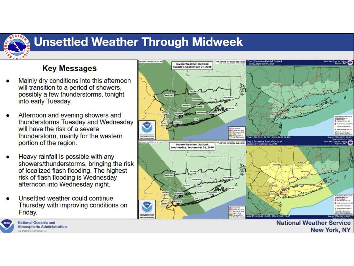
The National Weather Service predicts heavy rainfall will be possible with any storms, with the highest flooding risk on Wednesday afternoon and night.
“A severe thunderstorm is possible, with a risk for localized flash flooding, especially Wednesday,” the National Weather Service said.
The unsettled weather, with repeated chances for rain and thunderstorms, is expected to continue into Thursday, followed by nicer weather on Friday.
“Multiple rounds of showers and thunderstorms (are) expected tonight through Thursday,” the National Weather Service said.
Daily high temperatures through Thursday will be in the upper 70s to low 80s.
Calm, dry and sunny weather is predicted for Friday, with sunny skies and a high around 80, according to the National Weather Service.
Here are the forecast details for the lower Hudson Valley area via the National Weather Service:
This Afternoon: A slight chance of showers before 2 p.m., then a slight chance of showers after 5 p.m. Mostly cloudy, with a high near 78. Light southeast wind. Chance of precipitation is 20%.
Tonight: A chance of showers and thunderstorms, then showers and possibly a thunderstorm after 11 p.m. Low around 67. Light southeast wind. Chance of precipitation is 80%. New rainfall amounts between a tenth and quarter of an inch, except higher amounts possible in thunderstorms.
Tuesday: A chance of showers, with thunderstorms also possible after 11 a.m. Mostly cloudy, with a high near 83. Light and variable wind becoming west around 6 mph in the morning. Chance of precipitation is 30%.
Tuesday Night: A chance of showers and thunderstorms. Mostly cloudy, with a low around 65. East wind around 6 mph. Chance of precipitation is 40%.
Wednesday: Showers likely and possibly a thunderstorm before 2 p.m., then a chance of showers and thunderstorms after 2 p.m. Mostly cloudy, with a high near 76. Southeast wind around 7 mph. Chance of precipitation is 60%. New rainfall amounts between a tenth and quarter of an inch, except higher amounts possible in thunderstorms.
Wednesday Night: A chance of showers and thunderstorms before 8 p.m., then showers likely and possibly a thunderstorm between 8 p.m. and 2 a.m., then showers likely after 2 a.m. Mostly cloudy, with a low around 66. Chance of precipitation is 70%. New rainfall amounts between a half and three quarters of an inch possible.
Thursday: Showers likely and possibly a thunderstorm after 2 p.m. Mostly cloudy, with a high near 83. Chance of precipitation is 60%.
Thursday Night: Showers likely and possibly a thunderstorm before 8 p.m., then a chance of showers between 8 p.m. and 2 a.m. Mostly cloudy, with a low around 65. Chance of precipitation is 60%.
Friday: Mostly sunny, with a high near 80.
Here are the forecast details for the Mid-Hudson Valley area via the National Weather Service:
This Afternoon: Partly sunny, with a high near 79. Light southwest wind.
Tonight: A chance of showers before 11 p.m., then a chance of showers and thunderstorms between 11 p.m. and midnight, then showers likely and possibly a thunderstorm after midnight. Mostly cloudy, with a low around 66. Calm wind. Chance of precipitation is 70%. New rainfall amounts between a tenth and quarter of an inch, except higher amounts possible in thunderstorms.
Tuesday: A chance of showers and thunderstorms. Mostly cloudy, with a high near 80. Calm wind becoming south around 5 mph in the afternoon. Chance of precipitation is 50%. New rainfall amounts between a quarter and half of an inch possible.
Tuesday Night: Showers likely and possibly a thunderstorm. Mostly cloudy, with a low around 64. Calm wind. Chance of precipitation is 70%. New precipitation amounts between a tenth and quarter of an inch, except higher amounts possible in thunderstorms.
Wednesday: A chance of showers and thunderstorms, then showers likely and possibly a thunderstorm after 8am. Mostly cloudy, with a high near 76. Calm wind becoming southeast around 5 mph in the afternoon. Chance of precipitation is 70%. New rainfall amounts between a tenth and quarter of an inch, except higher amounts possible in thunderstorms.
Wednesday Night: Showers and possibly a thunderstorm. Low around 65. Chance of precipitation is 80%. New rainfall amounts between a half and three quarters of an inch possible.
Thursday: Showers likely, with thunderstorms also possible after 2 p.m. Partly sunny, with a high near 82. Chance of precipitation is 60%.
Thursday Night: Showers likely and possibly a thunderstorm before 8 p.m. Mostly cloudy, with a low around 62. Chance of precipitation is 60%.
Friday: Mostly sunny, with a high near 80.
Get more local news delivered straight to your inbox. Sign up for free Patch newsletters and alerts.