Weather
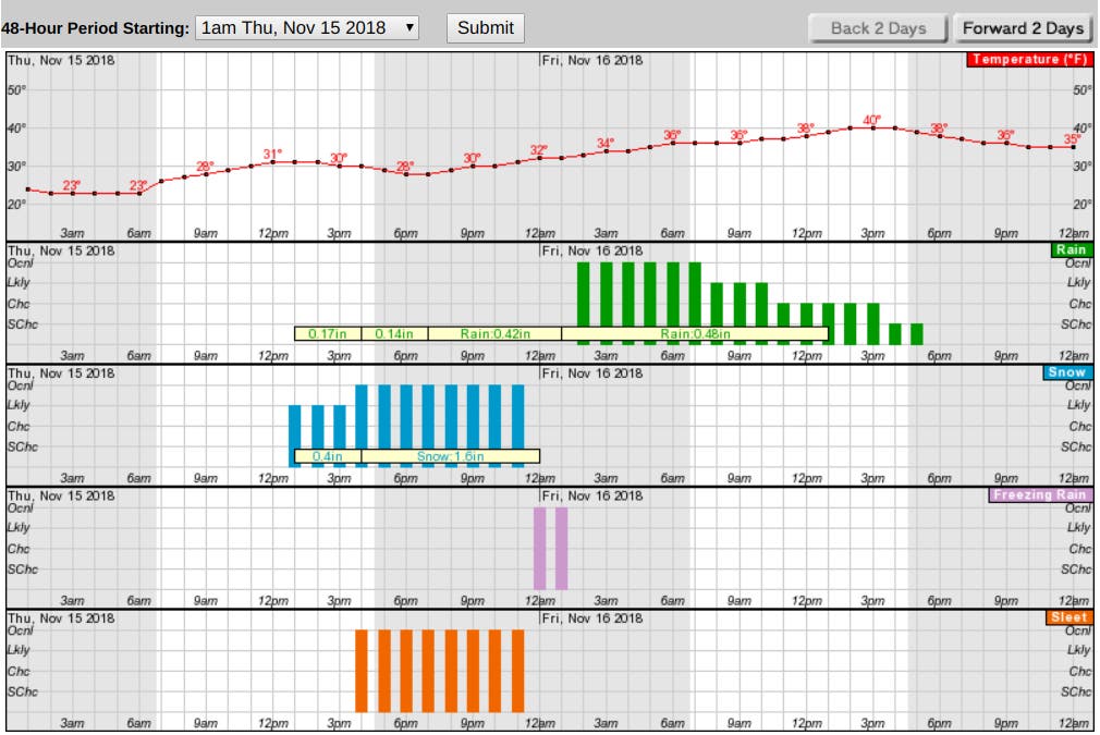
Hour-by-hour Hudson Valley Snow Forecast For Thursday
Snow will fall starting from south to north, with sleet and rain. The storm could also cause outages and is bound to make travel tricky.


HUDSON VALLEY, NY — A winter storm is headed to the region. However, estimates of snow accumulation vary, as do predictions about which areas will see mostly rain or a wintry mix.
"There are major keys to the forecast, that we are still trying to identify: 1. How much dry air will be ahead of the storm? 2. Does snow quickly mix with or change to sleet? 3. Do we get a burst of heavy snow Friday AM? These 3 details may seem small, but they mean everything in terms of accumulations," said Alex Marra and Bill Potter of Hudson Valley Weather.
What everyone is agreed on is that snow will fall starting Thursday from south to north, with sleet and rain right behind. The storm could also cause power outages and is just about guaranteed to make travel difficult.
Find out what's happening in New Cityfor free with the latest updates from Patch.
In addition to a hazardous weather outlook, the National Weather Service has now issued winter weather advisories for Orange, Putnam, Rockland and Westchester counties.
For Orange, Putnam and northern Westchester, the advisory is in effect from 1 p.m. Thursday to 4 a.m. Friday.
Find out what's happening in New Cityfor free with the latest updates from Patch.
- WHAT...Mixed precipitation expected. Total snow accumulations of 2 to 4 inches and ice accumulations of around one tenth of an inch expected.
- WHERE...Portions of northeast New Jersey and southeast New York
- ADDITIONAL DETAILS...Plan on slippery road conditions. The hazardous conditions should affect the evening commute.
For southern Westchester, it's in effect from 2 p.m. to 11 p.m. Thursday.
- WHAT...Snow expected. Total snow accumulations of 1 to 3 inches expected.
- WHERE...Southern Westchester County in New York and all of southern Connecticut
- ADDITIONAL DETAILS...Most of the accumulation will be on the grass, but roads should become slushy during the evening commute. Snow will change to rain in the evening.
For Dutchess and Ulster counties, the National Weather Service's hazardous weather outlook says the storm will start with snow beginning Thursday afternoon and evening. The snow may mix with sleet, freezing rain, and plain rain Thursday night into Friday morning. The Thursday evening and Friday morning commutes may be affected.
The storm is also going to wreak havoc on other traveling.
"Airline passengers and motorists can expect enough snow and ice to create a mess from Washington, D.C., to Baltimore; Philadelphia; Newark, New Jersey; New York City; Hartford, Connecticut; Boston; and Portland, Maine; even though a change to rain and flooding in poor drainage areas is forecast," said Alex Sosnowski, AccuWeather senior meteorologist. "Expect major delays and flight cancellations."
The lower Hudson Valley of New York is specially at risk for power outages, according to AccuWeather Meteorologist Dave Samuhel. "The risk is greatest where there still some leaves on the trees and in heavily-wooded areas."
Here's the hour-by-hour forecast from the National Weather Service for Mount Kisco:
Keep checking back with Patch for updated forecasts.
MAP: AccuWeather.com
TABLE: National Weather Service
Get more local news delivered straight to your inbox. Sign up for free Patch newsletters and alerts.