Weather
Hurricane Jose: Hazardous Weather Outlook Issued For The Hudson Valley
Here are details about the storm, whose "cone of uncertainty" now includes the Sound Shore. VIDEO

The NWS issued a Hazardous Weather Outlook for Orange, Putnam, Rockland and Westchester counties at 5:24 a.m. Saturday.
Tropical Cyclone Jose is forecast to lift north towards Long Island through early next week. While the exact strength and track of the storm remain uncertain, there is a low chance for strong gusty winds and heavy rain Tuesday into Wednesday.
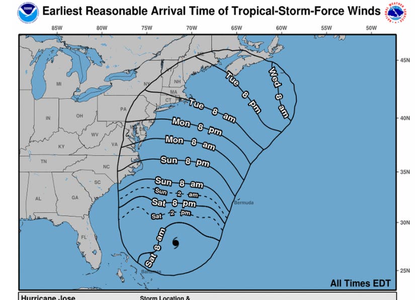
Jose increased in strength to a Category 1 Hurricane as it turned north. It could become a little stronger, and is expected to remain a hurricane for the next several days.The Sound Shore of Westchester is now in the "cone of uncertainty." However, when it passes southeast of Long Island late Tuesday through early Wednesday, it should have weakened again to a tropical storm, the NWS said. (To get more neighborhood stories like this, SIGN UP for Patch’s Daily Newsletter and Real Time News Alerts.)
Still wind and surge impacts will be felt well outside the cone, meteorologists said. Hurricane-force winds extend outward up to 35 miles (55 km) from the center and tropical-storm-force winds extend outward up to 150 miles (240 km).
Find out what's happening in New Cityfor free with the latest updates from Patch.
According to AccuWeather, gusts could strong enough to damage trees and cause sporadic power outages. Some rain will reach the coast. And that combination will lead to airline delays and slow travel on some highways.
The NWS said:
Find out what's happening in New Cityfor free with the latest updates from Patch.
Surge/Inundation Threat:
✓New moon Sep. 19; astronomical tides running high
✓Minor to locally Moderate coastal flooding possible, mainly across Atlantic Ocean south shore back bays.
Timing:
✓Peak impacts will increase Monday through Tuesday around the times of high tide.
Potential Impacts for Coastal Flooding:
✓Some inundation in shoreline communities and vulnerable areas.
✓Elevated threat of property damage - Several low-lying coastal and shoreline roads will be impassable and a few could be washed out.
Images: National Hurricane Center
Get more local news delivered straight to your inbox. Sign up for free Patch newsletters and alerts.