Home & Garden
Significant Snow Coming to Putnam, Rockland, Westchester: VIDEO
The weekend will be cold. Get out the snow shovels one more time. And just in case, check your Netflix wishlist.


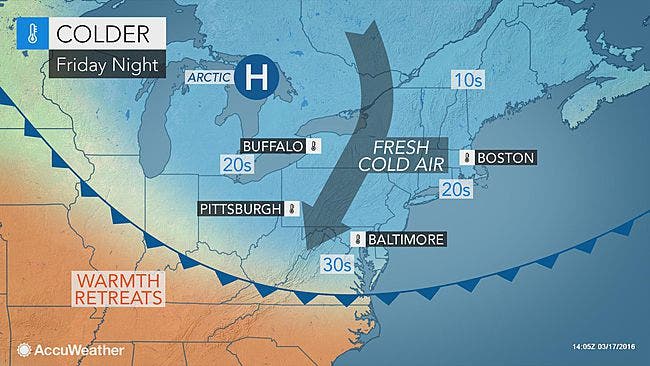
While meteorologists are still unsure of the storm's exact track, they all agree that the Hudson Valley will start off spring with a real snowstorm.
"All signs are beginning to point toward this storm being the real deal," said Bill Potter of Hudson Valley Weather.
The National Weather Service calls for minor coastal flooding as well.
Find out what's happening in New Cityfor free with the latest updates from Patch.
HVW said the snow accumulation predictions range, at this point, from 4-12 inches.
In one weather model the snow would start Sunday morning but only stick to the ground after sunset, around 8PM.
Find out what's happening in New Cityfor free with the latest updates from Patch.
Snow during the day would be mostly light, possibly accumulating as slush on grassy areas. The bulk of the storm would be east and north of New York.
But another forecast model has the snow starting later, around 2PM Sunday. The heart of the storm would come between 8PM and 2AM and could dump 8-12 inches of snow on the lower Hudson Valley.
Working backward, Saturday will be cold -- with temps in the 40s -- and feel even colder, and with the wind, it'll feel like it's below freezing.
Get more info from Hudson Valley Weather on YouTube:
MAP: AccuWeather.com
» News Alerts: Subscribe to a free email newsletter:
BEDFORD-KATONAH • BRONXVILLE-EASTCHESTER-TUCKAHOE • CHAPPAQUA-MOUNT KISCO • HARRISON • LARCHMONT-MAMARONECK • NANUET • NEW CITY • NEW ROCHELLE • NYACK-PIERMONT • OSSINING-CROTON-ON-HUDSON • PEARL RIVER • PEEKSKILL-CORTLANDT • PELHAM • PORT CHESTER • PLEASANTVILLE-BRIARCLIFF MANOR • RIVERTOWNS • RYE • SCARSDALE • SOUTHEAST-BREWSTER • TARRYTOWN-SLEEPY HOLLOW • WHITE PLAINS • YORKTOWN-SOMERS
Get more local news delivered straight to your inbox. Sign up for free Patch newsletters and alerts.