Weather
UPDATE: Snow Totals from Tuesday's Storm in the Hudson Valley
It's a wide range — from 9-33 inches.

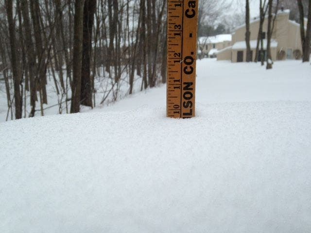
HUDSON VALLEY, NY — Here are the snow accumulation totals from Tuesday's storm as of Tuesday evening, from the National Weather Service (some late NWS totals via Hudson Valley Weather)
Dutchess County:
RHINEBECK 21.5
1 SW RED OAKS MILL 26
RED HOOK 23
HYDE PARK 19.5
Find out what's happening in New Cityfor free with the latest updates from Patch.
Orange County
OTISVILLE 24.0
MONTGOMERY 23.5
MOUNT HOPE 23.0 233 PM 3/14
GOSHEN 22.0 446 PM 3/14
GARDNERTOWN 20.0 330 PM 3/14
HIGHLAND MILLS 18.4 200 PM 3/14
CORNWALL LANDING 18.0 400 PM 3/14
BEREA 17.5 522 PM 3/14
NEW WINDSOR 17.0 256 PM 3/14
ORANGE LAKE 16.8 1200 PM 3/14
CORNWALL ON HUDSON 16.5 1230 PM 3/14
WARWICK 16.0 233 PM 3/14
Find out what's happening in New Cityfor free with the latest updates from Patch.
Putnam County
MAHOPAC 20.5
COLD SPRING 14.6
Rockland County
STONY POINT 18.1 230 PM 3/14
NEW CITY 16.0 435 PM 3/14
CONGERS 15.5 415 PM 3/14
AIRMONT 12.5 200 PM 3/14
Ulster County:
WEST SHOKAN 33.0 452 AM 3/15
HIGHMOUNT 32.0 759 AM 3/15
PLATTEKILL 24.0 1025 PM 3/14
PHOENICIA 23.7 742 AM 3/15
3 S KINGSTON 23.0 800 AM 3/15
COTTEKILL 21.0 759 AM 3/15
1 ENE PLATTEKILL 19.0 840 PM 3/14
ULSTER PARK 18.2 854 PM 3/14
KINGSTON 18.0 553 AM 3/15
SAUGERTIES 18.0 1028 PM 3/14
Westchester County
DOBBS FERRY 15.0 447 PM 3/14
SCARSDALE 15.0 519 PM 3/14
SOMERS 14.5 423 PM 3/14
CROTON HEIGHTS 14.5 428 PM 3/14
YORKTOWN HEIGHTS 14.5 430 PM 3/14
MOUNT KISCO 14.2 515 PM 3/14
IRVINGTON 14.0 306 PM 3/14
EASTCHESTER 13.0 200 PM 3/14
BEDFORD 13.0 200 PM 3/14
ARMONK 12.3 300 PM 3/14
MONTROSE 12.0 428 PM 3/14
KATONAH 11.0 504 PM 3/14
WHITE PLAINS 9.4 350 PM 3/14
Get more local news delivered straight to your inbox. Sign up for free Patch newsletters and alerts.