Weather
When Thunderstorms Will Likely Start In The Hudson Valley
The NWS's hazardous outlooks have been updated for a very hot and humid day. Here are the details.

HUDSON VALLEY, NY — The forecasters have nothing good to say about Saturday. Hazardous weather outlooks have been issued up and down the Hudson Valley.
It will also be very hot and humid today and it may feel like 94 degrees in the afternoon.
For Orange, Putnam, Rockland and Westchester counties, the National Weather Service predicts isolated strong to severe thunderstorms this afternoon into this evening, with wind gusts that could be damaging, and localized flash flooding.
Find out what's happening in New Cityfor free with the latest updates from Patch.
For Dutchess and Ulster, there's even more:
The combination of hot temperatures and increasing humidity levels may produce dangerous heat conditions with heat indices into the low to mid 90s in portions of the Capital District and mid Hudson Valley today. If confidence increases in heat indices of 95F or greater, then heat advisories will need to be issued.
In addition, showers and thunderstorms are expected to become numerous to widespread areawide today, especially in the afternoon and evening. Heavy downpours are likely in any thunderstorm, which could result in urban and poor drainage flooding. Isolated flash flooding is possible if multiple rounds of thunderstorms occur over a given area. There is also a marginal risk for severe weather with the main threat being isolated damaging winds.
Very humid conditions continue today across the area with a southerly flow off the ocean. Dew points in the 70's will help create Heat Index values above 90 in most spots. Watch for symptoms of heat stress if out doors and drink plenty of fluids. pic.twitter.com/7UO2k6X9nM
— NWS New York NY (@NWSNewYorkNY) July 6, 2019
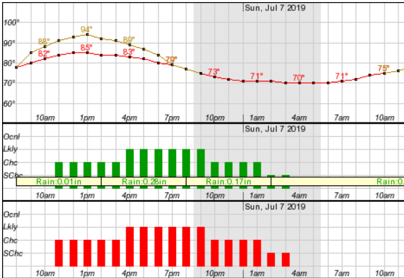
But the rain may not be limited to the afternoon and evening. Here's the NWS's hourly forecast from 8 a.m. Saturday through 11 a.m. Sunday.
Find out what's happening in New Cityfor free with the latest updates from Patch.
SEE ALSO:
‘Skinny House’: Own A Unique Piece Of Americana In The Hudson Valley
Get more local news delivered straight to your inbox. Sign up for free Patch newsletters and alerts.