Weather
Big Changes in Nyack's Christmas Weekend Weather Forecast
Say goodbye — for now — to the bitter cold in Piermont and Nyack.

PIERMONT, NY — Yes, it’s finally officially winter. We've already gotten cold, so why care? Because the winter solstice arrived at 5:44 a.m. and, from this point on, the days will be getting longer.
Now, with a few brutally cold days and (in most of the Hudson Valley) a few inches of snow behind us, what’s next in the lead-up to Christmas Day?
There's good news on two fronts: the temperatures and travel weather.
Find out what's happening in Nyack-Piermontfor free with the latest updates from Patch.
“Right on cue… things will warm up,” said Bill Potter of Hudson Valley Weather. “Now, don’t expect an immediate surge of warmth in the Hudson Valley... but at least we’ll see an improvement on the daily highs in the 20s that we’ve been saddled with.”
It will not be as warm as it was last year at this time, but you will be able to feel the difference, with high temperatures around 40.
Find out what's happening in Nyack-Piermontfor free with the latest updates from Patch.
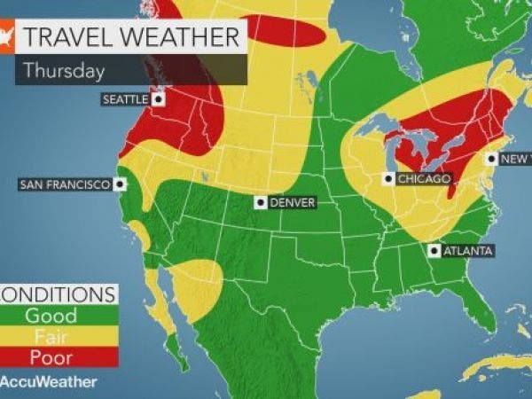
As for travel weather, forecasters are now downplaying the possibility of precipitation on Thursday. If you have travel plans, only minor weather-related travel issues are anticipated for much of the nation this week, according to AccuWeather.com, though if you're headed out west, you may encounter a large storm there during the Christmas weekend.
Here is the updated forecast through Christmas Day from the National Weather Service for Rockland County:
Today
Mostly sunny. Highs in the lower 40s. West winds 5 to 10 mph.
Tonight
Mostly cloudy. Lows in the upper 20s. West winds around 5 mph in the evening...becoming light and variable.
Thursday
Mostly cloudy with a slight chance of rain showers. A slight chance of snow showers in the morning. Highs in the lower 40s. South winds around 5 mph...becoming west with gusts up to 20 mph in the afternoon. Chance of precipitation 20 percent.
Thursday Night
Partly cloudy. Lows in the upper 20s. Northwest winds 5 to 10 mph with gusts up to 25 mph.
Friday
Sunny. Highs in the lower 40s. West winds 5 to 10 mph.
Friday Night
Partly cloudy in the evening...then becoming mostly cloudy. Lows in the upper 20s.
Saturday
Mostly cloudy. A chance of snow and rain in the morning...then a chance of rain in the afternoon. Highs in the lower 40s. Chance of precipitation 50 percent.
Saturday Night
Partly cloudy. Lows in the upper 20s.
Christmas Day
Mostly sunny. Highs in the mid 40s.
Sunday Night
Partly cloudy in the evening...then becoming mostly cloudy. Lows in the upper 20s.
Image via AccuWeather.com
Get more local news delivered straight to your inbox. Sign up for free Patch newsletters and alerts.

