Community Corner
Driving Ban Lifted: Nyack, Piermont Storm Central Jan. 27
Prep, power, forecasts, travel—Find the news and info you need to weather the snowstorm.

Here’s what you need to know—most recent forecast, safety tips at home and on the road, what to do if the power goes out and more.
Jan. 27
--------------------------------------------------------------------
Find out what's happening in Nyack-Piermontfor free with the latest updates from Patch.
Jan. 26
- Gov. Cuomo Imposes Total Driving Ban After 11 p.m.
- Gov. Cuomo Declares State of Emergency for Putnam, Rockland, Westchester
Water: Firefighters need to get to fire hydrants in emergencies. Tomorrow, shovel the nearest hydrant out. Learn more about storing drinking water and dealing with water pipes:
Find out what's happening in Nyack-Piermontfor free with the latest updates from Patch.
United Water New York customers can get updated information by calling 845-623-1500 or by visitingwww.unitedwater.com/uwny
Schools: Nyack schools have early dismissals Monday, Jan. 26. So does Albertus Magnus High School.
Be Prepared: Get your home prepped before the snow starts, advises the Red Cross. Have enough water for three days for each person, check your flashlights and foodstuffs. Learn more:
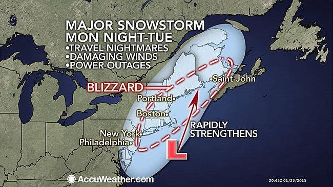
Travel: Gov. Andrew Cuomo warns that I-84, Metro North and the Thruway may close Monday. Flight cancellations will rapidly mount on Tuesday with airports likely forced to close for a time on Tuesday from New York City northward, say accuweather.com meteorologists.
Don’t drive unless it’s absolutely necessary, New York State Police say. If you do, carry food, water and warm blankets as well as a shovel, road salt, a flashlight. For road conditions, traffic, travel and transit info, use http://511ny.org/ or call 511.
- Travel Tips from the State Police, Jan. 26, 27
- Trains, Planes and Buses: Transportation Schedule Changes
- Cuomo: Metro North, Thruway, I-84 May Shut Down Before Monday Evening
Power Problems:
- Go to the Orange and Rockland website to report outages and track restoration. You can also: Use the O&R Mobile app: Download the mobile app from your iPhone, iPad or Android device.Text Messaging: Text “OUT” to 69678 (myORU) and follow the prompts.1-877-434-4100: Follow the voice prompts.
Local Forecast as of 6:39PM Jan. 26:
- Tonight-Snow with widespread blowing snow. The snow could be heavy at times. Some thunder is also possible. Low around 20. Wind chill values between 5 and 10. Blustery, with a north wind 18 to 23 mph, with gusts as high as 37 mph. Chance of precipitation is 100%. Total nighttime snow accumulation of 10 to 14 inches possible.
- Tuesday-Snow with widespread blowing snow. The snow could be heavy at times. Some thunder is also possible. High near 25. Wind chill values between 5 and 10. Blustery, with a north wind 16 to 22 mph, with gusts as high as 36 mph. Chance of precipitation is 100%. New snow accumulation of 7 to 11 inches possible.
- Tuesday Night-Light snow likely, mainly before 9pm. Mostly cloudy, with a low around 16. Wind chill values between 5 and 10. Northwest wind 10 to 15 mph, with gusts as high as 30 mph. Chance of precipitation is 70%. New snow accumulation of less than a half inch possible.
- Wednesday-Mostly cloudy, then gradually becoming sunny, with a high near 24. Wind chill values between 5 and 10. Northwest wind 11 to 15 mph.
MAP: accuweather.com
» News Alerts: Subscribe to a free email newsletter:
BEDFORD-KATONAH • BRONXVILLE-EASTCHESTER-TUCKAHOE • CHAPPAQUA-MOUNT KISCO • HARRISON • LARCHMONT-MAMARONECK • NANUET • NEW CITY • NEW ROCHELLE • NYACK-PIERMONT • OSSINING-CROTON • PEARL RIVER • PEEKSKILL-CORTLANDT • PELHAM • PORT CHESTER • PLEASANTVILLE-BRIARCLIFF • RIVERTOWNS •RYE • SCARSDALE • SOUTHEST-BREWSTER • TARRYTOWN-SLEEPY HOLLOW • WHITE PLAINS • YORKTOWN-SOMERS
Get more local news delivered straight to your inbox. Sign up for free Patch newsletters and alerts.