Weather
Storms To Usher In Memorial Day Weekend: Hudson Valley Forecast
Travel will be tricky, what with holiday traffic and thunderstorms.

HUDSON VALLEY, NY — The long Memorial Day holiday will start off wet and stormy and end up hot and sunny.
"This weekend looks like it starts out unsettled, before improving more and more as we head into Sunday and Monday," said Alex Marra and Bill Potter of Hudson Valley Weather.
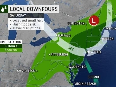
AccuWeather meteorologists have outlined a nearly 1,000-mile-long swath of thunderstorms from southern Georgia to eastern New York that could be capable of producing powerful wind gusts, hail and isolated tornadoes Friday afternoon and into the evening.
Find out what's happening in Nyack-Piermontfor free with the latest updates from Patch.
"Weather is likely to be a disruptive force at the outset of the holiday weekend travel rush," said Alex Sosnowski, AccuWeather senior meteorologist. "For those hitting the road early, downpours and severe thunderstorms may cause some issues."
Orange & Rockland Utilities announced it was making storm preparations. O&R’s company and contractor overhead line crews and its tree removal experts are planning to upgrade from routine work to storm alert at 6 p.m. Friday evening. Customer service operations and the wide array of O&R teams that support those functions also will shift into storm duty at that time.
Find out what's happening in Nyack-Piermontfor free with the latest updates from Patch.
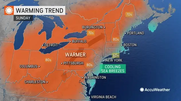
Then what a change! Temps will jump the 60s, 70s and low 80s on Friday and Saturday to widespread highs in the 80s on Sunday and Monday.
Here's the National Weather Service daily forecast based on New City:
- Thursday Afternoon - Mostly cloudy, with a high near 70. South wind around 10 mph.
- Thursday night - A 30 percent chance of showers or drizzle. Patchy fog after 2am. Otherwise, cloudy, with a low around 60. South wind around 6 mph.
- Friday - A chance of showers, then showers likely and possibly a thunderstorm after 2pm. Patchy fog before 11am. Otherwise, cloudy, with a high near 78. South wind 5 to 9 mph, with gusts as high as 20 mph. Chance of precipitation is 70%. New rainfall amounts between a tenth and quarter of an inch, except higher amounts possible in thunderstorms.
- Friday Night - Showers likely and possibly a thunderstorm. Cloudy, with a low around 63. South wind 6 to 8 mph, with gusts as high as 20 mph. Chance of precipitation is 70%. New rainfall amounts between a quarter and half of an inch possible.
- Saturday - A chance of showers and thunderstorms, then showers likely and possibly a thunderstorm after 2pm. Mostly cloudy, with a high near 77. Southwest wind around 7 mph. Chance of precipitation is 60%. New rainfall amounts between a tenth and quarter of an inch, except higher amounts possible in thunderstorms.
- Saturday Night - Showers likely before 8pm. Mostly cloudy, with a low around 58. Chance of precipitation is 60%.
- Sunday - Sunny, with a high near 79.
- Sunday Night - Partly cloudy, with a low around 60.
- Memorial Day - Mostly sunny, with a high near 89.
- Monday Night - Partly cloudy, with a low around 66.
- Tuesday - Mostly sunny, with a high near 92.
Get more local news delivered straight to your inbox. Sign up for free Patch newsletters and alerts.

