Weather
When Storm Will Arrive, What Will Fall: Hudson Valley Forecast
Here are details on winter advisories, a flood warning, gusty winds and the re-freeze to follow,


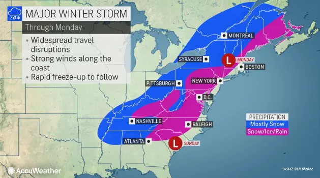
HUDSON VALLEY, NY — The massive, unusual storm system due to hit New York State from south to north Sunday evening is expected to start in the Hudson Valley with snow, sleet and freezing rain then change to freezing and plain rain overnight.
The National Weather Service has issued Winter Weather Advisories for Dutchess, Ulster, Orange and Putnam counties.
- In Orange and Putnam, snow should start falling around 7 p.m. The counties could get 2-4 inches of snow topped by a couple hundredths of an inch of ice.
- In Dutchess and Ulster, snow should start falling around 10 p.m. Snow and sleet accumulations of 2 to 6 inches and ice accumulations of up to a tenth of an inch. Winds could gust as high as 40 to 50 mph in the Taconics.
Rockland and Westchester counties could get 1-2 inches of snow and/or 1-2 inches of rain. Snow, rain and freezing rain with sleet are likely to start around 6 p.m., changing to rain and freezing rain around midnight, and to all rain before dawn. Snow and sleet accumulation around an inch. Ice accumulation around a trace.
Find out what's happening in Nyack-Piermontfor free with the latest updates from Patch.
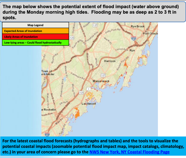
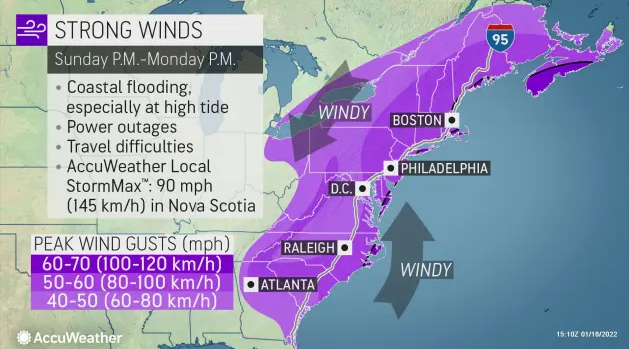
A flood warning and a wind advisory are in effect for the coastal communities of southern Westchester.
Some flooding could go into areas that normally don’t experience it. Numerous low-lying and shoreline roads could be flooded, with adjacent properties taking on water. Cars may be destroyed if not moved to higher ground. From midnight to 8 a.m. Monday, gusty winds could blow around unsecured objects. Tree limbs could be blown down and a few power outages may result.
Find out what's happening in Nyack-Piermontfor free with the latest updates from Patch.
Across the region, gusty winds could bring down tree branches. Utility companies are preparing for scattered outages.
The storm will have a very different effect on various parts of the Hudson Valley.
"This is a very complex region to forecast for, micro climates, local topography, coastal storm tracks are all considerations into the forecast. We will see 0-12' plus amounts over a less than 50 mile radius," said Alex Marra and Bill Potter of Hudson Valley Weather.
The storm started in western Canada and has taken a very unusual path. It has already dumped snow on the Plains and Midwest, the Tennessee Valley and the South before pivoting up the East Coast spreading snow and rain throughout the mid-Atlantic, New York, New England and eastern Canada. About 100 million Americans will feel its effects, said Alex Sosnowski, AccuWeather senior meteorologist.
Cold air will rush in its wake, and any wet and slushy areas will freeze, so roads, sidewalks and parking lots could be slippery and dangerous Monday afternoon, overnight and Tuesday.
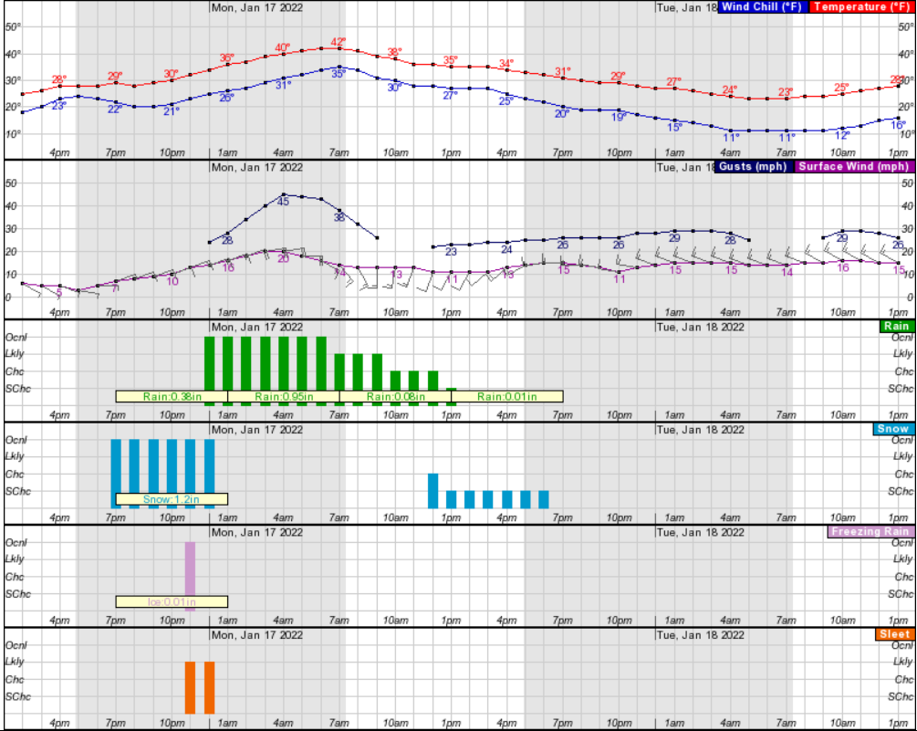
Here's an hour-by-hour look at the storm and its aftermath based on Rockland County:
Here's the daily forecast from the National Weather Service for the next five days based on northern Westchester:
- Sunday afternoon - Mostly sunny. Not as cool with highs in the lower 30s. East winds 5 to 10 mph.
- Sunday night - Snow, rain and freezing rain with sleet likely in the evening, then rain and freezing rain after midnight. Snow and sleet accumulation around an inch. Ice accumulation around a trace. Breezy and not as cool with lows in the upper 20s. Temperature rising into the lower 40s after midnight. East winds 10 to 15 mph with gusts up to 25 mph, increasing to 15 to 25 mph with gusts up to 45 mph after midnight. Chance of precipitation near 100 percent.
- Martin Luther King Jr Day - Rain in the morning, then rain likely with a chance of snow in the afternoon. Highs in the lower 40s. South winds 15 to 20 mph with gusts up to 45 mph, becoming southwest 10 to 15 mph with gusts up to 25 mph in the afternoon. Chance of precipitation near 100 percent.
- Monday Night - Mostly cloudy. Lows in the lower 20s. West winds 10 to 15 mph with gusts up to 30 mph.
- Tuesday - Sunny. Highs in the upper 20s. Northwest winds 15 to 20 mph with gusts up to 30 mph.
- Tuesday Night - Mostly clear in the evening, then becoming mostly cloudy. Lows 15 to 20.
- Wednesday - Mostly cloudy. Highs around 40.
- Wednesday Night - Cloudy. A chance of snow and rain showers after midnight. Lows in the mid 20s. Chance of precipitation 40 percent.
Get more local news delivered straight to your inbox. Sign up for free Patch newsletters and alerts.

