Weather
Snow-Packed Nor'Easter Could Deliver Glancing Blow: HV Forecast
A winter storm watch has been issued for Westchester County for Friday night through Saturday evening. Here's the latest.


HUDSON VALLEY, NY — The large storm expected to intensify as it tracks northeastward off the East Coast could wallop Westchester County and bring the rest of the region a few inches of snow and some gusty winds.
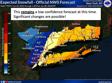
The National Weather Service issued a winter storm watch for all of Westchester from Friday evening to Saturday evening. It also updated its hazardous outlooks for the rest of the Hudson Valley, where it says there's only a low-to-moderate potential for 6 or more inches of snow.
A gale warning has been issued for all of Long Island Sound.
Find out what's happening in Ossining-Croton-On-Hudsonfor free with the latest updates from Patch.
In Westchester, heavy snow is possible from late Friday night through Saturday afternoon, as are total accumulations of 6 to 12 inches, the NWS said. Winds could gust as high as 45 mph. Still, "Considerable uncertainty remains with the track of this storm and therefore its impacts, which should be refined over the next 24 to 36 hours."
"The current consensus is the HV on the very western edge of any snow … with the storm focused on New England," said Alex Marra and Bill Potter on Hudson Valley Weather's Facebook page.
Find out what's happening in Ossining-Croton-On-Hudsonfor free with the latest updates from Patch.
Forecasters say we won't escape entirely.
"The sprawling New York City metro area, in particular, is likely to experience a wide range of accumulations. In northwestern New Jersey, only an inch or two of snow could fall, but areas in central Long Island, New York, will face over a foot of snow," said Alex Sosnowski, AccuWeather senior meteorologist.
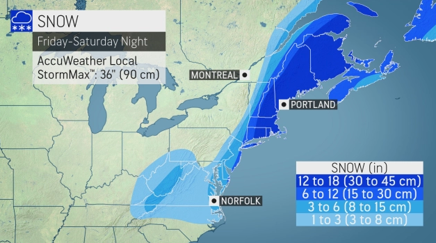
The nor'easter, now developing off the coast of the Carolinas, could rapidly strengthen enough as it moves northward into the weekend to be dubbed a bomb cyclone, Sosnowski said. "A bomb cyclone, or bombogenesis, occurs when the central pressure of a storm crashes by 0.71 of an inch (24 millibars) or more within 24 hours. The plunging pressure will cause air to rush into the center of the storm — just like a giant vacuum. The high winds will pull in copious amounts of moisture, helping to enhance precipitation."
It's expected to bring blizzard conditions to eastern Rhode Island, Massachusetts, New Hampshire and Maine.
Get more local news delivered straight to your inbox. Sign up for free Patch newsletters and alerts.


