Weather
Wintry Mix Will Mess Up Thursday AM Commute: HV Forecast
Snow is part of the hazardous weather outlook.

HUDSON VALLEY, NY — A storm system headed through the region Wednesday night could mean snow-covered and icy roads for the Thursday morning commute, then more Arctic air.
The National Weather Service has updated its hazardous outlook for Dutchess and Ulster counties and issued one for Orange, Putnam, Rockland and Westchester.
Total snow accumulation might not total an inch, but snow mixed with rain will be combined with temperatures below freezing.
Find out what's happening in Pearl Riverfor free with the latest updates from Patch.
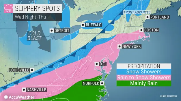
In the Mid-Hudson, wind chill values could go to 7 degrees below zero, especially across the higher elevations Thursday night into Friday morning.
Plus, it'll stay cold.
Find out what's happening in Pearl Riverfor free with the latest updates from Patch.
"The southward displacement of the polar vortex causing this wave of cold air will continue to bring frigid conditions to the Midwest and Northeast over the next couple of weeks," said Jessica Storm, AccuWeather Meteorologist.
Here's the five-day forecast from the National Weather Service (based on Rockland County)
- Wednesday - Mostly cloudy late this morning, then becoming partly sunny. Highs in the lower 40s. Southwest winds 10 to 15 mph with gusts up to 25 mph.
- Wednesday night - Mostly cloudy. A chance of rain in the evening, then snow and rain likely after midnight. Snow accumulation around an inch. Lows in the upper 20s. Southwest winds 5 to 10 mph with gusts up to 20 mph, becoming west after midnight. Chance of precipitation 70 percent.
- Thursday - Cloudy with snow likely in the morning, then partly sunny in the afternoon. Total snow accumulation of 1 to 3 inches possible. Highs in the lower 30s. Northwest winds 5 to 10 mph. Chance of snow 70 percent.
- Thursday Night - Partly cloudy. Much cooler with lows around 8 above. North winds 5 to 10 mph. Wind chill values as low as 4 below.
- Friday - Mostly sunny. Cold with highs around 20. North winds 5 to 10 mph. Wind chill values as low as 5 below.
- Friday Night - Partly cloudy in the evening, then becoming mostly cloudy. Lows around 10 above. Wind chill values as low as 5 below.
- Saturday - Partly sunny. Cold with highs in the mid 20s. Wind chill values as low as 5 below in the morning.
- Saturday Night - Partly cloudy in the evening, then becoming mostly cloudy. Lows 10 to 15.
- Sunday - Partly sunny. Highs in the lower 30s.
- Sunday Night - Mostly cloudy. Lows 15 to 20.
Get more local news delivered straight to your inbox. Sign up for free Patch newsletters and alerts.