Weather
Arctic Blast Will Bring Weekend Shivers: Hudson Valley Forecast
The plummeting temps will be a real shock to the system because it's been so warm.


HUDSON VALLEY, NY — It's going to get really, really cold for a couple of days.
"The end result will likely be similar to the arctic blast we experienced around Christmas," said Bill Potter of Hudson Valley Weather.
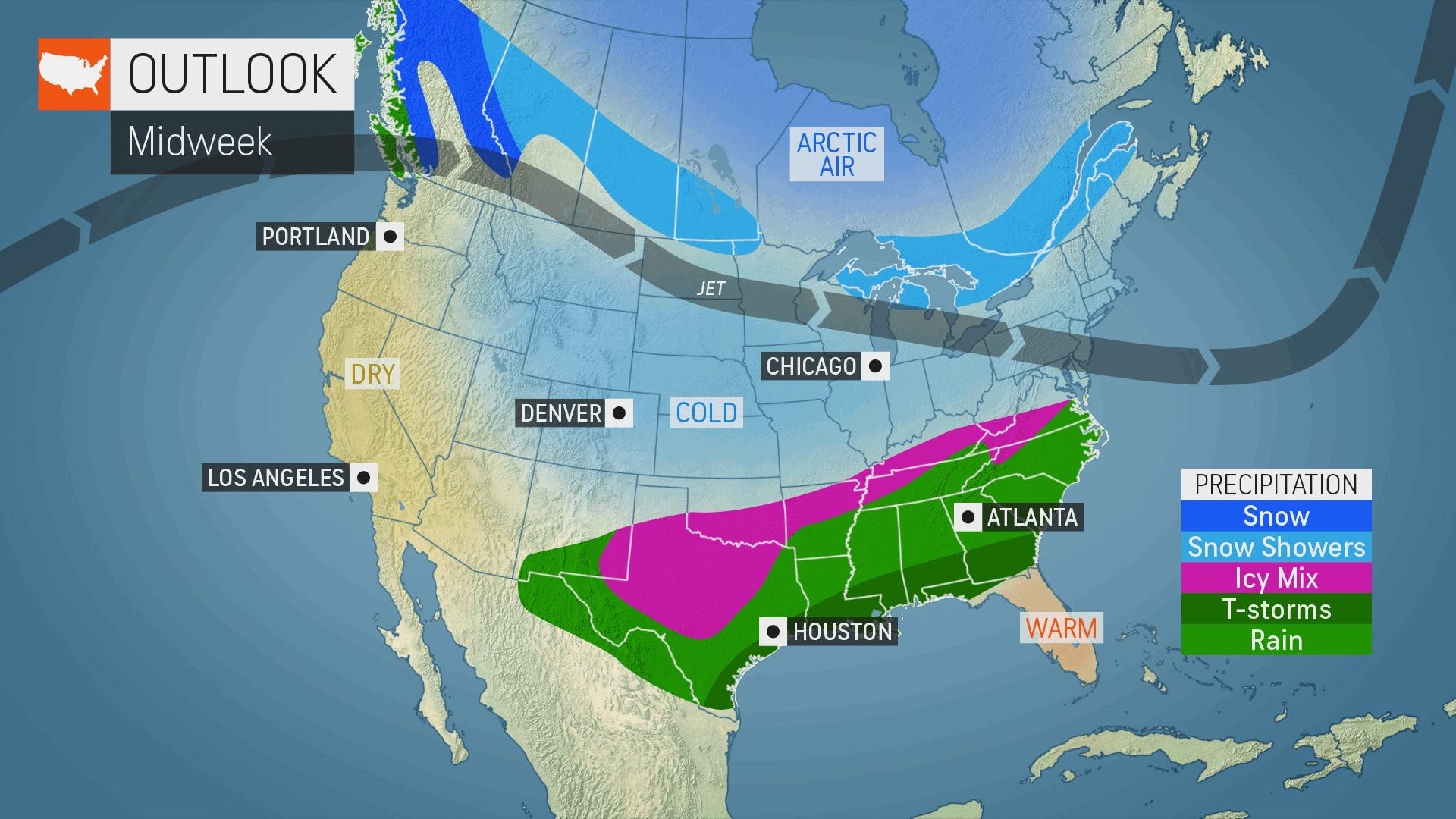
The chill will begin to creep in at midweek.
Find out what's happening in Pearl Riverfor free with the latest updates from Patch.
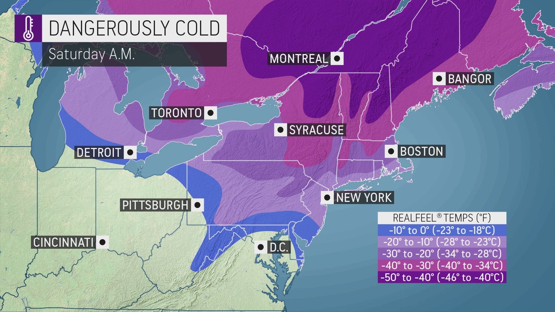
But it's the end of the week that's going to make us wish it felt like 0 degrees. The risk of frostbite on exposed skin will be very high from Friday night to Saturday, said Alex Sosnowski, AccuWeather senior meteorologist.
The plummeting temps will be a real shock to the system because it's been so warm.
Find out what's happening in Pearl Riverfor free with the latest updates from Patch.
"High temperatures tend to range from near 20 in northern Maine to near 40 in New York City and the mid-40s in southeastern Virginia during late January," Sosnowski said. "Instead, temperatures have been poking as high as 15 degrees above those levels at times this month."
However, it won't be for long. An Alberta clipper storm traveling across southern Canada will cause the wind direction to shift on Sunday, and temperatures could surge over the following days by up to 40 degrees on average, AccuWeather said.
Here's a look at the week from the National Weather Service, based on Rockland County:
- Monday night - A chance of rain showers before 3am, then a chance of rain and snow showers. Mostly cloudy, with a low around 35. Calm wind becoming northwest 5 to 8 mph in the evening. Chance of precipitation is 50%.
- Tuesday - Partly sunny, with a high near 39. Northwest wind 9 to 13 mph.
- Tuesday Night - Mostly cloudy, with a low around 18. Wind chill values between 10 and 15. North wind around 7 mph.
- Wednesday - Partly sunny, with a high near 36. West wind 6 to 8 mph.
- Wednesday Night - Partly cloudy, with a low around 23.
- Thursday - Mostly sunny, with a high near 39.
- Thursday Night - Partly cloudy, with a low around 20.
- Friday - Mostly sunny, with a high near 26. Blustery.
- Friday Night - Mostly clear, with a low around 1. Blustery.
- Saturday - Sunny and cold, with a high near 19.
- Saturday Night - Partly cloudy, with a low around 15.
Note there's no snow in the forecast. The previous record for the latest date of measurable snowfall for a given winter in New York City was broken Monday, the National Weather Service said. Recordkeeping began in 1869.
Get more local news delivered straight to your inbox. Sign up for free Patch newsletters and alerts.