Weather
Hour-By-Hour Snow, Sleet, Freezing Rain Long Island Forecast
"It just takes a small amount of ice to make roads and sidewalks a skating rink."


A hazardous weather outlook remains in effect for Long Island with a wintry mix of precipitation expected to fall during the latter half of Monday.
"Accumulations will be light, but the timing will impact the evening commute," the National Weather Service says.
It's the potential for freezing rain, especially, that has forecasters urging commuters to take it slow on the ride home.
Find out what's happening in Sachemfor free with the latest updates from Patch.
"While heavy precipitation is not anticipated by the storm at this time, it just takes a small amount of ice to make roads and sidewalks a skating rink," AccuWeather Chief Meteorologist Elliot Abrams says.
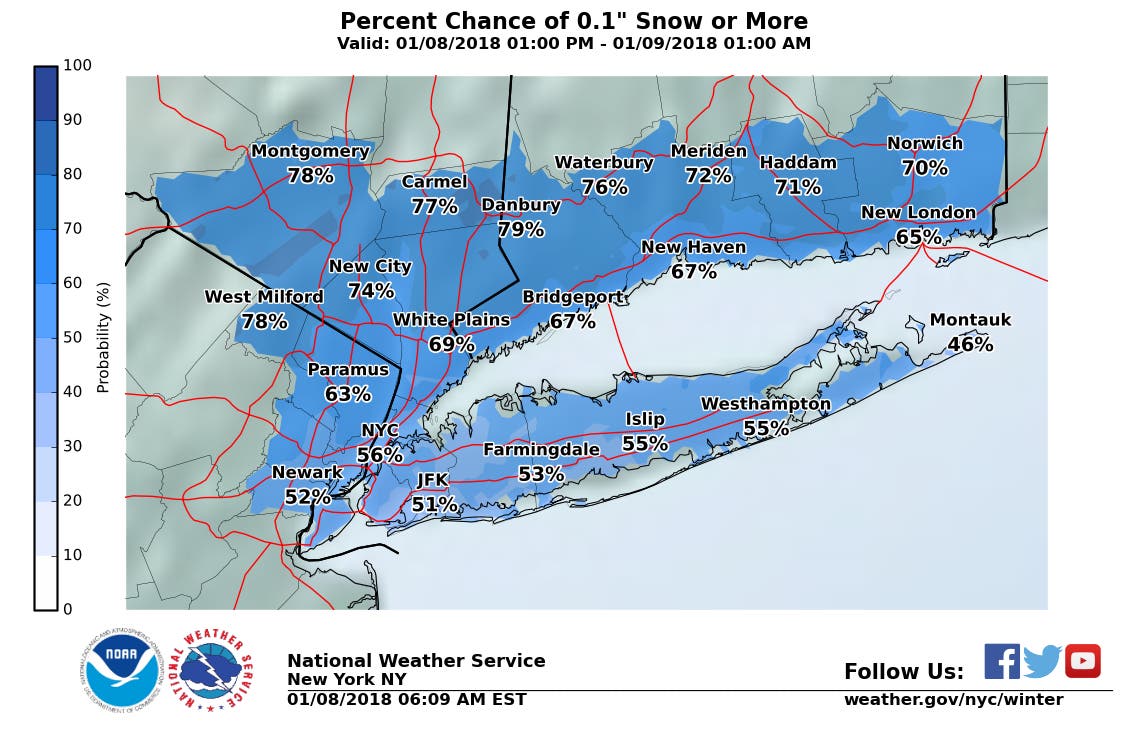
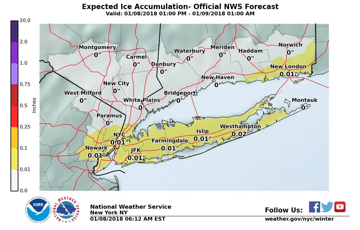
There's about a 55 percent chance that the island sees at least a coating of snow. Ice accumulation is expected to be around one hundredth of an inch.
Find out what's happening in Sachemfor free with the latest updates from Patch.
The hour-by-hour forecast for Monday afternoon and evening:
3 p.m.- 20 percent chance of precipitation; slight chance of snow, freezing rain and sleet
4 p.m.- 20 percent chance of precipitation; slight chance of snow, freezing rain and sleet
5 p.m.- 61 percent chance of precipitation; snow and slight likely; chance of freezing rain
6 p.m.- 61 percent chance of precipitation; snow and slight likely; chance of freezing rain
7 p.m.- 61 percent chance of precipitation; snow and slight likely; chance of freezing rain
8 p.m.- 50 percent chance of precipitation; chance of snow
9 p.m.- 50 percent chance of precipitation; chance of snow
10 p.m.- 12 percent chance of precipitation
But there is hope in sight:
A widespread January thaw is expected for much of the country with above normal temperatures for mid-month. pic.twitter.com/C9tLgQ0WR6
— NWS (@NWS) January 7, 2018
The full forecast:
Monday- Sleet likely, possibly mixed with snow and freezing rain, mainly after 5pm. Mostly cloudy, with a high near 35. Wind chill values between 10 and 20. Southwest wind 10 to 16 mph, with gusts as high as 26 mph. Chance of precipitation is 60%. Little or no ice accumulation expected. Total daytime snow and sleet accumulation of less than a half inch possible.
Monday Night- Snow and sleet likely, possibly mixed with freezing rain, becoming all snow after 8pm, then gradually ending. Cloudy, then gradually becoming partly cloudy, with a low around 30. Wind chill values between 20 and 25. Southwest wind 10 to 14 mph. Chance of precipitation is 60%. Little or no ice accumulation expected. New snow and sleet accumulation of less than a half inch possible.
Tuesday- Sunny, with a high near 40. Wind chill values between 20 and 30. Northwest wind 11 to 14 mph.
Tuesday Night- Mostly clear, with a low around 22. Northwest wind 5 to 10 mph becoming light north after midnight.
Wednesday- Partly sunny, with a high near 39. Calm wind becoming south around 6 mph in the afternoon.
Wednesday Night- Mostly cloudy, with a steady temperature around 38.
Thursday- Mostly cloudy, with a high near 48.
Thursday Night- Rain likely, mainly after midnight. Areas of fog after midnight. Otherwise, cloudy, with a low around 44. Chance of precipitation is 60%.
Main image by AccuWeather.com
Get more local news delivered straight to your inbox. Sign up for free Patch newsletters and alerts.