Weather
The Latest On 2 Long Island Snow Threats
We've got the latest details on two weather systems forecasters are watching that could bring some snow to Long Island.


Forecasters are continuing to watch two weather systems that could potentially bring snow to Long Island in the coming days.
The first system could impact the island Thursday night into Friday, the National Weather Service says. There's currently a 30 percent chance of snow.
"While it is not likely to strengthen into a major winter storm, the system could still spread a narrow swath of accumulating snow from part of the lower Great Lakes on Thursday to a portion of the mid-Atlantic by early Friday," AccuWeather reports.
Find out what's happening in Sachemfor free with the latest updates from Patch.
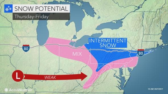
The NWS is predicting just coating of snow for Long Island, but the weather service says there's about a 12 percent chance of more than an inch of snow accumulating by 7 a.m. Friday.
Joe Cioffi, a meteorologist for WPIX-TV and FiOS1 News, is a bit more bullish on the snow forecast. He's currently predicting 2-3 inches of accumulation on the island.
Find out what's happening in Sachemfor free with the latest updates from Patch.
The second snow threat will come this weekend. There's a 30 percent chance of snow on Sunday, which is down from 40 percent in earlier forecasts.
"The trend over the last few model cycles is for this system to pass to the south with little impact to the local area," the NWS says.
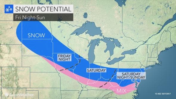
"It is possible the storm from Thursday to Friday pulls down enough cold air to shift snow farther south during the storm this weekend," AccuWeather Chief Meteorologist Elliot Abrams said. "It is just a bit too early to say for sure, since the storm was still over the central Pacific Ocean as of Tuesday afternoon."
The full forecast:
Tuesday Afternoon- A 50 percent chance of showers. Cloudy, with a high near 49. South wind 11 to 13 mph.
Tuesday Night- Periods of rain. Low around 46. Breezy, with a southwest wind 14 to 20 mph. Chance of precipitation is 80%. New precipitation amounts between a tenth and quarter of an inch possible.
Wednesday- Periods of rain, mainly before noon. High near 57. Southwest wind 11 to 16 mph. Chance of precipitation is 80%.
Wednesday Night- Mostly clear, with a low around 37. West wind 13 to 16 mph.
Thursday- Sunny, with a high near 50. West wind 14 to 17 mph, with gusts as high as 29 mph.
Thursday Night- A chance of rain and snow between 10pm and 2am, then a chance of snow after 2am. Mostly cloudy, with a low around 31. Chance of precipitation is 30%.
Friday- A chance of snow before 2pm, then a chance of rain. Mostly cloudy, with a high near 42. Chance of precipitation is 30%.
Friday Night- Partly cloudy, with a low around 21.
Saturday- Mostly sunny, with a high near 29.
Saturday Night- A 30 percent chance of snow after 2am. Mostly cloudy, with a low around 21.
Sunday- A 30 percent chance of snow. Mostly cloudy, with a high near 32.
Patch file photo
Get more local news delivered straight to your inbox. Sign up for free Patch newsletters and alerts.