Community Corner
WEATHER UPDATE: What, When and How Much?
Snow mostly, but rain will sometimes mix in, according to the 3 advisories issued for Brewster by the National Weather Service.

The National Weather Service has three advisories out for Brewster:
- Winter Weather Advisory is in effect until February 22, 08:00 AM EST
- Special Weather Statement is in effect
- Hazardous Weather Outlook is in effect
“Travel will continue to be hazardous through the overnight into tomorrow morning so travel with care,” says Hudson Valley Weather.
Hour by hour: snow started at around 1 p.m. and will taper off by 10 a.m. Sunday. Temperatures will rise, from 25 degrees at 4 p.m. hitting 30 degrees at midnight and 31 between 1 and 2 a.m.
Find out what's happening in Southeast-Brewsterfor free with the latest updates from Patch.
- Late Afternoon-Snow. High near 27. Wind chill values between 15 and 20. South wind around 9 mph. Chance of precipitation is 100%. Total daytime snow accumulation of 1 to 3 inches possible.
- Tonight-Snow and freezing rain, becoming all snow after 2am. Temperature rising to around 30 by midnight. Wind chill values between 15 and 20. South wind 3 to 7 mph. Chance of precipitation is 100%. Little or no ice accumulation expected. New snow accumulation of 3 to 5 inches possible.
- Sunday-A chance of snow and freezing rain before 10am, then a slight chance of rain and snow between 10am and noon. Partly sunny, with a high near 39. Wind chill values between 30 and 35. Calm wind becoming west around 5 mph. Chance of precipitation is 30%.
- Sunday Night-Partly cloudy, with a low around 8. Calm wind becoming northwest 5 to 9 mph in the evening.
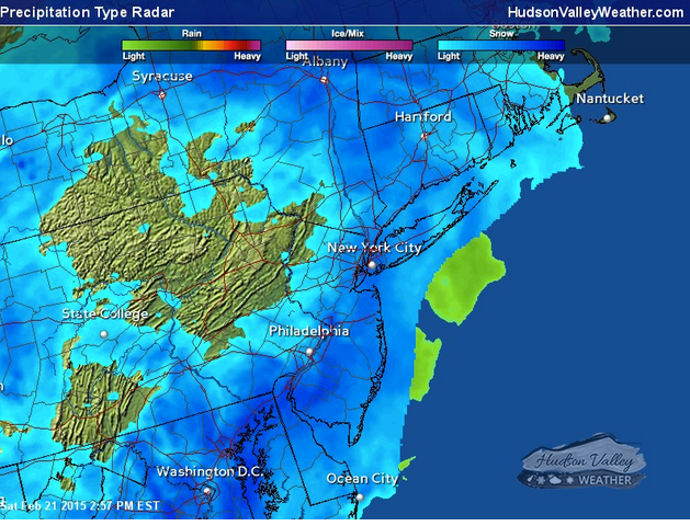
RADAR MAP: Hudson Valley Weather
Get more local news delivered straight to your inbox. Sign up for free Patch newsletters and alerts.