Weather
Hazardous Weather Outlook Dropped for Hudson Valley in Connection to Hurricane Matthew
The good news? No hurricane. The bad news? We could have used the rainfall.

In two days a lot has changed concerning Hurricane Matthew and its possible impact on the Hudson Valley.
On Tuesday, meteorologists were worried that New York could be greatly impacted by the powerful storm, and by Wednesday it appeared the storm would have minimal, if any, impact on the state.
And on Thursday, the latest track reveals that Matthew will offer no impact to New York’s weekend weather forecast after all.
Find out what's happening in Tarrytown-Sleepy Hollowfor free with the latest updates from Patch.
The National Weather Service officially dropped its Hazardous Weather Outlook for Orange, Putnam, Rockland and Weschester counties, which had been in effect through Wednesday. Dutchess and Ulster counties were never under a hazardous outlook.
And of course this is great news for us in the Hudson Valley that the hurricane won’t impact us at all, but concerns will intensify about how limit rainfall there has been in New York.
Find out what's happening in Tarrytown-Sleepy Hollowfor free with the latest updates from Patch.
As the National Weather Service forecast stands now, the mid- and lower-Hudson Valley will have anywhere from a 40 percent to 60 percent chance of rain on Saturday. Fingers crossed.
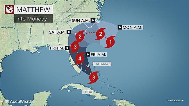
Hurricane Matthew was approaching Andros Island in the Bahamas Thursday morning as its outer bands neared Florida’s east coast. With powerful maximum sustained winds of 125 mph, the system was a strong Category 3 storm that the National Hurricane Center expects will gain more strength as the day moves on.
As of the hurricane center's 8 a.m. Oct. 6 update, Matthew was positioned about 30 miles south-southwest of Nassau, Bahamas. The system was moving northwest at 12 mph.
“Additional strengthening is expected today, and Matthew is forecast to be a Category 4 hurricane as it approaches the east coast of Florida,” the hurricane center’s report said. Hurricane-force winds extended out up to 40 miles Thursday morning. Tropical-storm force winds extended out 160 miles, forecasters said.
On its current projected path, Matthew could make landfall somewhere along Florida’s east coast as a major hurricane. While the storm's outer bands were arriving near Florida Thursday morning, forecasters do not expect it to clear the Sunshine State until late Friday night.
Additional reporting by Sherri Lonon and Brian McCready, Patch Staff
Photo credit: Accuweather.com
Get more local news delivered straight to your inbox. Sign up for free Patch newsletters and alerts.