Weather
Storms Bringing Dangerous Heat To The Hudson Valley
The NWS has already issued a Hazardous Weather Outlook for Friday - Monday, but first storms could bring an inch of rain.

HUDSON VALLEY, NY — Fronts moving through the region Wednesday and Thursday will bring humid air and the possibilities of heavy rain showers and thunderstorms. But it's what's behind the front that counts.
First: the National Weather Service warns that locally heavy rainfall is possible, and could lead to isolated flooding of urban, small stream, and poor drainage areas.
"Showers and thunderstorms will be possible around sunset and into the night," said Hudson Valley Weather. "A batch of heavy rain and thunderstorms is possible as sunrise approaches on Thursday, which could lead to a very soggy start to our Thursday AM commute."
Find out what's happening in White Plainsfor free with the latest updates from Patch.
Weather conditions in the Northeast states trends downhill today as a storm system approaches. Not much good news to deliver; cloudy, damp, increasing rain chances as the day goes on. #njwx #nywx #ctwx #pawx pic.twitter.com/KDFTZtCfJd
— NY Metro Weather (@nymetrowx) June 27, 2018
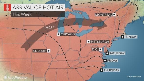
When that blows over, we'll be starting a heat wave that looks to be particularly brutal.
Hazardous Weather Outlooks for Dutchess, Orange, Putnam, Rockland, Ulster and Westchester counties have already been issued by the National Weather Service.
Find out what's happening in White Plainsfor free with the latest updates from Patch.
"While heat waves are common around Independence Day, this pattern could bring the hottest early July weather for such a broad area of the Northeast since 2012," said AccuWeather Meteorologist Evan Duffey.
Even though it's supposed to be hot in the summer, such a heat wave can be dangerous, said Alex Sosnowski from AccuWeather, citing not only deteriorating air quality but also heat exhaustion and stroke.
Here's what the NWS offers as a five-day forecast:
- Today-A 20 percent chance of showers after 2pm. Mostly cloudy, with a high near 74. Southeast wind 6 to 8 mph.
- Tonight-Showers likely, then showers and thunderstorms after 2am. Steady temperature around 68. Southeast wind 6 to 8 mph. Chance of precipitation is 80%. New rainfall amounts between a quarter and half of an inch possible.
- Thursday-Showers and thunderstorms, mainly before noon. High near 81. South wind 5 to 7 mph. Chance of precipitation is 80%. New rainfall amounts between a quarter and half of an inch possible.
- Thursday Night-Partly cloudy, with a low around 66. Light and variable wind becoming west around 5 mph.
- Friday-Sunny, with a high near 87. Northwest wind 3 to 6 mph.
- Friday Night-Mostly clear, with a low around 66.
- Saturday-Sunny, with a high near 90.
- Saturday Night-Mostly clear, with a low around 71.
- Sunday-Sunny, with a high near 92.
- Sunday Night-Mostly clear, with a low around 72.
Image: AccuWeather.com
Get more local news delivered straight to your inbox. Sign up for free Patch newsletters and alerts.