Home & Garden
WEATHER UPDATE: Winter Weather Advisory Issued for Somers and Yorktown
We'll let you know when the first day of spring snow will begin, and what impact it will have on your work commute.

It’s only fitting after the winter we’ve had that snow is in the forecast for the first day of spring.
The National Weather Service has issued an Advisory for northern Westchester:
AccuWeather.com Senior Meteorologist Alex Sosnowski had good news and bad news:
Find out what's happening in Yorktown-Somersfor free with the latest updates from Patch.
On a positive note, the storm on Friday into Saturday could be very photogenic. The wet nature of the snow could cling to tree limbs and surround early spring flowers that have begun to bloom.
The snow is not likely to be heavy enough to weigh down a great number tree limbs, so that any power outages would be very sporadic.
Find out what's happening in Yorktown-Somersfor free with the latest updates from Patch.
but
Additional waves of cold air are forecast to move in through the first part of April and could lead to additional opportunities for late-season snow in the region.
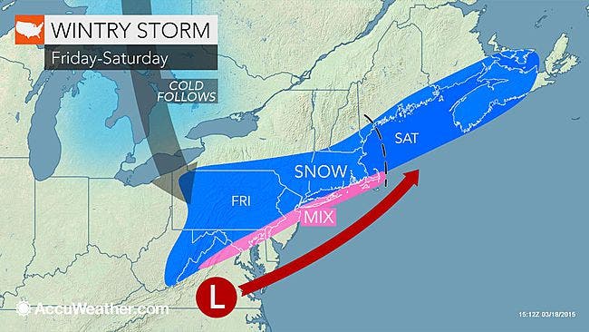
Here’s a timeline for Friday’s snow event from Hudson Valley Weather:
- Snow begins between 10am and 2pm on Friday
- Snow falls light to moderate at times thru the afternoon hours
- Snow tapers off from west to east between 6pm and 10pm on Friday
The evening rush hour could be affected, Sosnowski said, “Since paved surfaces absorb a considerable amount of warmth from the sun this time of the year, it would have to snow hard to make roads slippery during the daylight hours. However, even a light to moderate snow falling early in the morning, toward evening or at night can be enough to make roads slushy. Motorists should be on the lookout for slippery roads in the suburbs, as well as bridges, underpasses and areas that do not receive much sunlight.”
In all, the region could see 3-5 inches of accumulation, with all the accompanying travel problems we’ve become familiar with this winter.
Here’s the forecast from the NWS:
- Today-Sunny. Highs in the upper 30s. Northwest winds around 10 mph.
- Tonight-Mostly clear in the evening...then becoming partly cloudy. Lows around 19. North winds 5 to 10 mph in the evening... Becoming light and variable.
- Friday-Cloudy...snow...mainly in the afternoon. Total snow accumulation of 3 to 5 inches. Cold with highs in the lower 30s. East winds 5 to 10 mph. Chance of snow 90 percent.
- Friday Night-Cloudy with a 50 percent chance of snow. Lows in the mid 20s. Northeast winds 5 to 10 mph.
- Saturday-Partly sunny. A slight chance of snow in the morning. Highs in the lower 40s. Northwest winds around 5 mph...becoming southwest around 5 mph in the afternoon. Chance of snow 20 percent.
- Saturday Night-Mostly cloudy in the evening...then becoming partly cloudy. Lows in the mid 20s.
- Sunday-Mostly sunny. Highs in the upper 30s.
- Sunday Night-Mostly clear. Lows around 20.
- Monday-Sunny. Highs in the upper 30s.
MAP: AccuWeather.com
Get more local news delivered straight to your inbox. Sign up for free Patch newsletters and alerts.