Weather
'Extremely Active' Hurricane Season Possible: NOAA's Adjusted Forecast
As the peak of the 2017 Atlantic hurricane season nears, NOAA forecasters are now predicting a higher chance for a more active season.

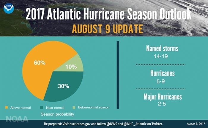
CHARLOTTE, NC — With the peak of the 2017 Atlantic hurricane season just days away from starting, forecasters at the National Oceanic and Atmospheric Administration have upped their predictions for an above-normal number of storms. Back in May, NOAA forecast a 45 percent chance of an above-normal season. On Wednesday, that number rose to a 60 percent chance.
“The season has the potential to be extremely active, and could be the most active since 2010,” NOAA warned in issuing its revised forecast. That season gave birth to such named storms as Hurricane Alex, Tropical Storm Hermine and Hurricane Danielle. All told, there were 19 named storms, according to NOAA records.
NOAA forecasters say there is a strong chance for 14 to 19 named storms to crop up this season. This is compared with the projection of 11 to 17 issued in May. Of those storms, two to five of them are expected to be major hurricanes, which is an increase from May’s projection of two to four. Major hurricanes are those that have maximum sustained winds of at least 111 mph. The estimate of five to nine hurricanes in total issued in May remains unchanged, forecasters say.
Find out what's happening in Charlottefor free with the latest updates from Patch.
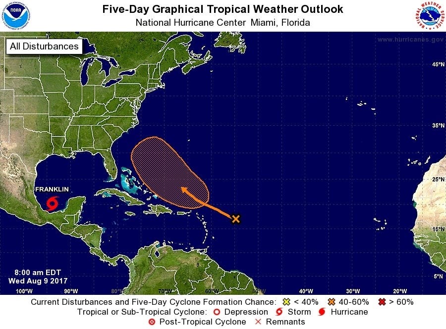
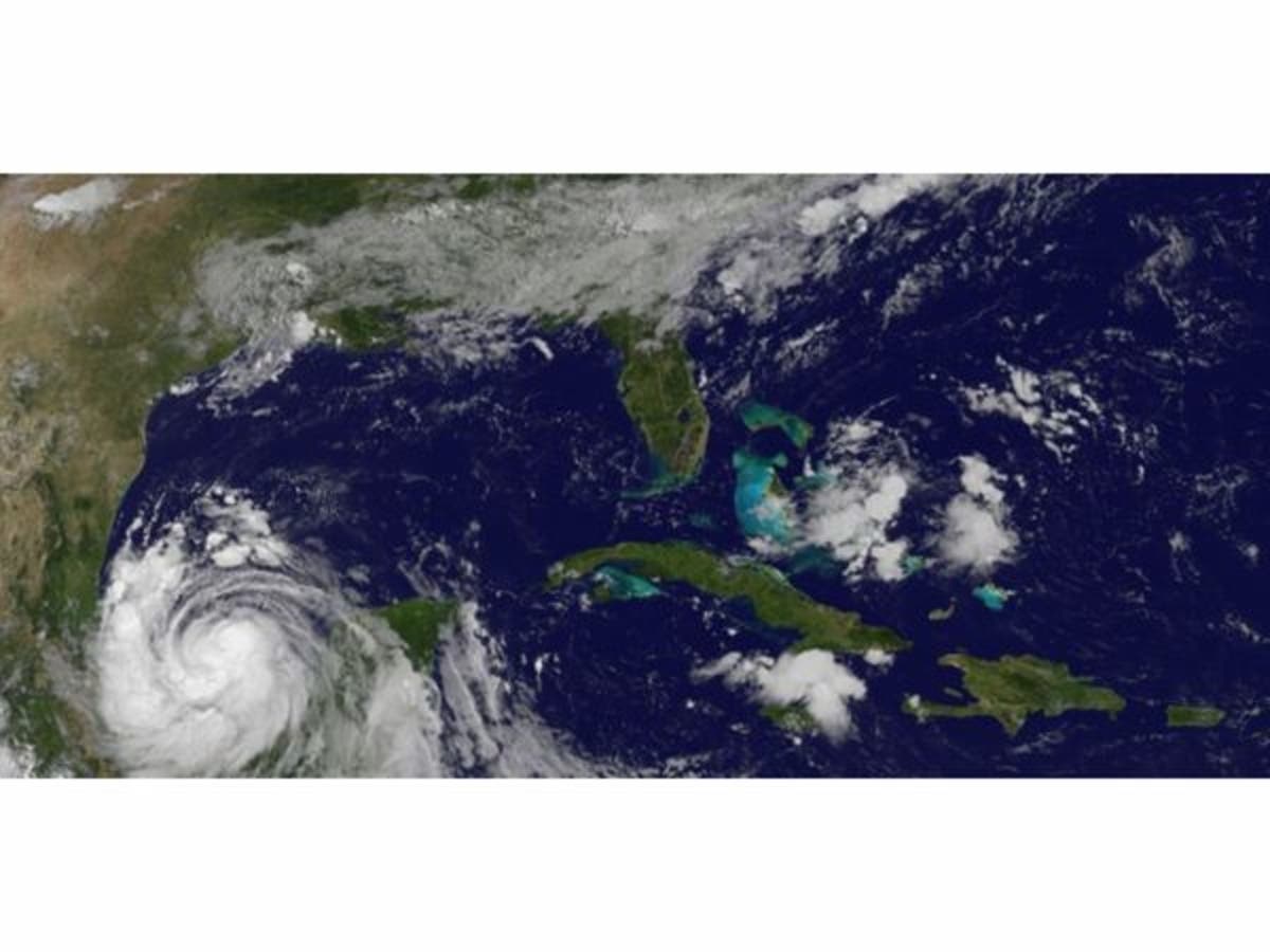
NOAA’s upgraded predictions arrived Wednesday as forecasters were keeping an eye on the season’s sixth-named storm. Tropical Storm Franklin was located off the coast of Mexico as of the morning of Aug. 8. It is expected to reach hurricane status before making landfall.
Meanwhile, forecasters are also monitoring an area of disturbed weather in the Atlantic Ocean that has been given a 40 percent chance of developing more over the next five days. As of Wednesday morning, that storm system was on a path that might take it in the direction of South or North Carolina. Should that storm gain enough steam to earn a name, it will be called Gert. (Get Patch real-time email alerts for the latest news in Charlotte — or other neighborhoods. And iPhone users: Check out Patch's new app.)
Find out what's happening in Charlottefor free with the latest updates from Patch.
“We’re now entering the peak of the season when the bulk of the storms usually form,” Gerry Bell, Ph.D., lead seasonal hurricane forecaster at NOAA’s Climate Prediction Center, said in announcing the updated predictions. “The wind and air patterns in the area of the tropical Atlantic and Caribbean where many storms develop are very conducive to an above-normal season. This is in part because the chance of an El Nino forming, which tends to prevent storms from strengthening, has dropped significantly from May.”
Warmer-than-predicted water in the tropical Atlantic Ocean also prompted the adjusted forecast.
The Atlantic hurricane season runs from June 1 to Nov. 30 each year. Average seasons produce about 12 named storms, of which six become hurricanes. Three of the hurricanes are generally deemed major.
“Today’s updated outlook underscores the need for everyone to know their true vulnerabilities to storms and storm surge,” said FEMA Administrator Brock Long. “As we enter the height of hurricane season, it’s important for everyone to know who issues evacuation orders in their community, heed the warnings, update their insurance and have a preparedness plan.”
About The Peak Of Hurricane Season
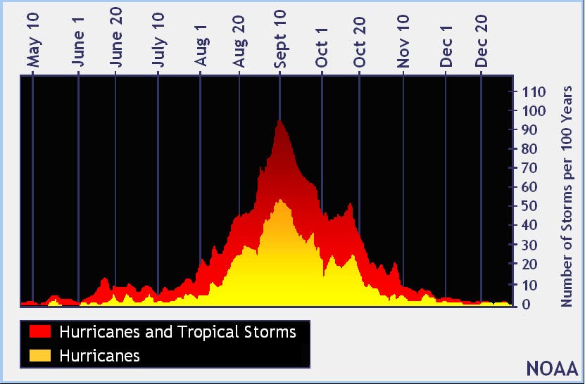
Forecasters call the period between mid-August and mid-October the “season within the season.” This eight-week period “is often the most active and dangerous time for tropical cyclone activity,” according to the National Oceanic and Atmospheric Administration.
The peak period is historically responsible for major spikes in tropical weather activity, NOAA said. In fact, it accounts for roughly 78 percent of all tropical storm days on record. It is also the period when 87 percent of the category 1 and 2 hurricane days on record occurred. In addition, this period is responsible for “a whopping 96 percent of the major (category 3, 4 and 5) hurricane days.”
So, what makes this eight-week stretch so special?
“Tropical waves are coming off of the coast of Africa roughly every three days, and the very early and late parts of the year provide additional types of potential seedlings,” NOAA’s website explains.
Other environmental conditions during the peak tend to be more conducive for storm development, as well. The factors that align during the peak period include wind, temperature and moisture. Wind shear that might rip disturbances apart in May, for example, tend to weaken by late August, NOAA said.
“This minimum in the shear combines with favorable thermodynamics – ocean temperatures in the deep tropics that increase with each day of summer sun, warmer air temperatures, and increasing atmospheric moisture,” NOAA explained. “When the dynamics and thermodynamics are in sync, as they often are from mid-August through early October, disturbances like African tropical waves can easily strengthen.”
The conditions gradually become less ripe for development in mid-October when increased wind shear tends to reappear and water and air temperatures cool.
Residents readying for the ongoing season can get tips and advice on the federal government’s Ready.gov website.
Keep up with more news you can use by liking Charlotte Patch on Facebook:
Graphics courtesy of the National Hurricane Center and NOAA
» Patch Editor Sherri Lonon contributed to this article
Get more local news delivered straight to your inbox. Sign up for free Patch newsletters and alerts.