Weather
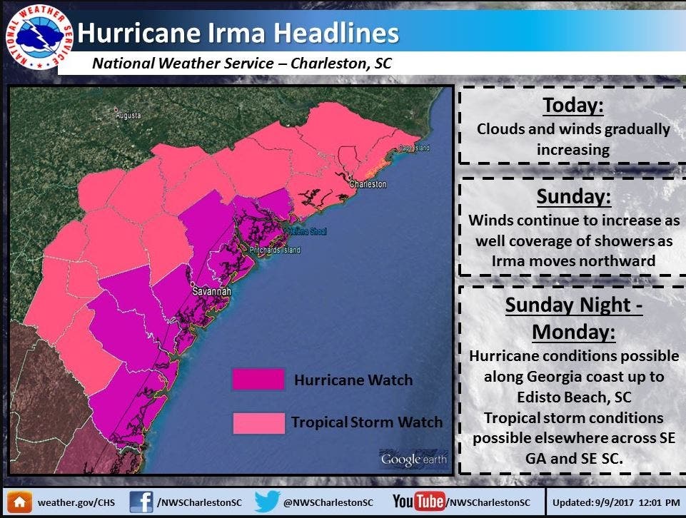
Hurricane Irma: Hurricane Watch In Effect For South Carolina Coast
A hurricane watch was in effect for the coast of South Carolina Saturday morning as Irma made its advance on Florida.


A hurricane watch was placed on portions of the South Carolina coast Saturday morning as the entire coastline of Florida was under a hurricane warning in anticipation of Hurricane Irma’s landfall Sunday.
Hurricane warnings mean that hurricane conditions are expected in the warning area within the next 36 hours.
Hurricane Irma approached Cuba Saturday morning as a powerful Category 5 storm. By 11 a.m., the National Hurricane Center said Irma's clash with the island nation had weakened her to Category 3 status. Still very much classified a "major" hurricane, Irma remained on a path that is expected to have potentially catastrophic impacts on Florida's west coast and the Tampa Bay area.
Find out what's happening in Charlottefor free with the latest updates from Patch.
The 11 a.m. forecast showed a slight westward shift in Irma’s projected path, with tropical depression conditions reaching western Tennessee and Kentucky by 8 a.m. Thursday.
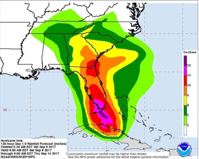
The National Hurricane Center predicted Saturday that Irma has the potential to bring at least two to four inches of rain to the Charlotte metro area, while Florida is bracing for more than 20 inches.
Find out what's happening in Charlottefor free with the latest updates from Patch.
Watch: Hurricanes Jose And Irma Seen From Space
Some areas of the Carolinas could see even more rain, according to a National Hurricane Center advisory. “Residents throughout the southeast states should remain aware of the flood threat and stay tuned to forecasts and warnings,” it said.
The Charlotte area will begin to see signs of the storm Sunday, when winds will begin stirring around 10-20 mph, with winds picking up to gusts by Monday, according to WBTV forecasters. While Irma’s core will stay to the west of the Carolinas, centering over Georgia and Tennessee where it will downshift to a tropical depression. Even so, by Monday afternoon the Charlotte area will see wind gusts in the 45-55 mph range, WBTV said.
By 11 a.m. Saturday, Irma, the behemoth that tore through the Caribbean, leaving at least 20 people dead in its wake, was packing maximum sustained winds of 125 mph. Irma was located about 175 southeast of Key West, moving west at 9 mph.
On its current projected path, Irma is expected to clear the northern Cuban coastline on Saturday and make landfall in Florida sometime Sunday.

Although weakened somewhat, hurricane center forecasters warn that Irma remains a powerful storm. The current projections show her retaining major hurricane status after clearing the Tampa Bay area on Monday.
"Irma is expected to make landfall in Florida as an extremely dangerous major hurricane, bringing life-threatening wind impacts to much of the state regardless of the exact track of the center," the center wrote in its 11 a.m. Sept. 9 update. "Wind hazards from Irma are also expected to spread northward along the coast of Georgia and South Carolina where a hurricane watch has been issued."
Forecasters say Irma’s hurricane-force winds extend out 70 miles from the center, while tropical storm-force winds reach out 195 miles.
Patch Editor Sherri Lonon contributed to this report
Images courtesy of National Weather Service
Keep up with more Hurricane Irma news by liking Charlotte Patch on Facebook:
Get more local news delivered straight to your inbox. Sign up for free Patch newsletters and alerts.