Weather
NC On Alert As Tropical Storm Nestor Swirls In Gulf Of Mexico
Tropical storm Nestor has strengthened in the Gulf of Mexico and is expected to bring heavy rain to NC. Here's how much rain may fall.


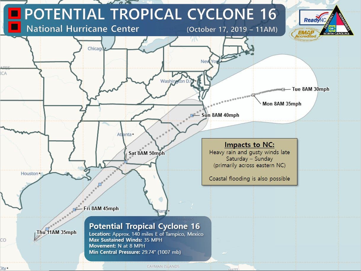
NORTH CAROLINA — A tropical storm gaining strength in the Gulf of Mexico has prompted storm surge warnings for the northern Gulf Coast states and is expected to dump several inches of rain on the Carolinas before early next week, according to the National Weather Service. On Friday after the National Hurricane Center upgraded the potential cyclone in the Gulf of Mexico to a tropical storm.
A National Oceanic and Atmospheric Administration hurricane hunter aircraft investigating the storm reports that the system has strengthened with sustained winds of 60 mph.
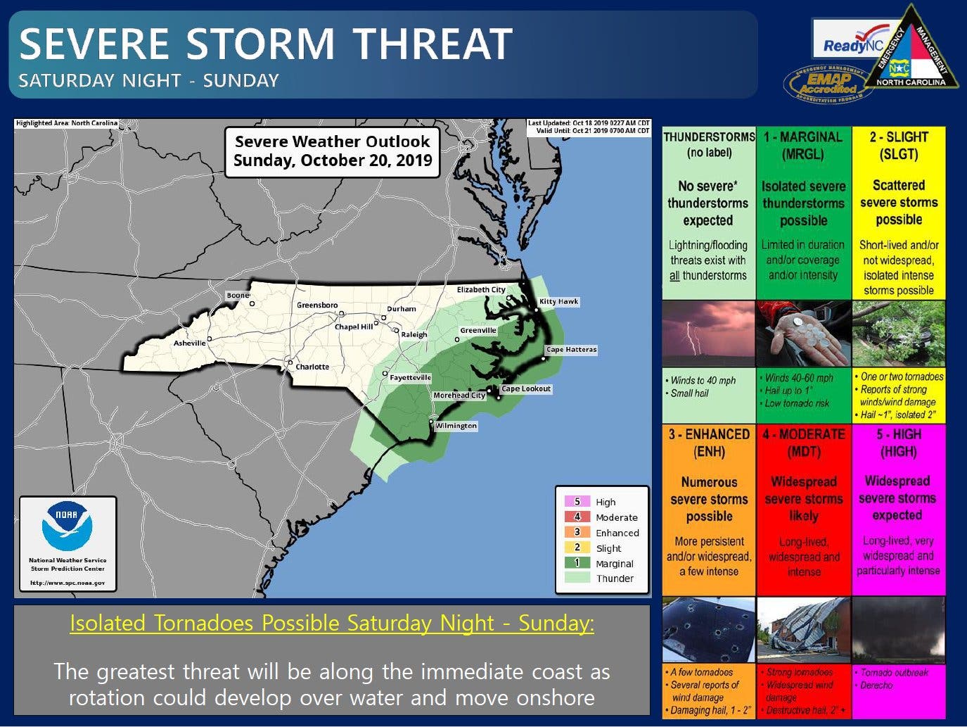
Emergency officials in North Carolina warn that heavy rain and gusty winds are to be expected Saturday into Sunday, primarily across the eastern end of the state, with coastal flooding possible.
Find out what's happening in Charlottefor free with the latest updates from Patch.
As of 1 p.m. Friday, “Potential Tropical Cyclone Sixteen” had maximum sustained winds of about 60 mph and was about 195 miles south of the mouth of the Mississippi River or 355 miles southwest of Panama City, Florida, according to the National Hurricane Center.
Tropical storm conditions were expected along the coast in the warning area along the Gulf Coast later Friday, which could make storm preparations dangerous. “Gale-force winds are possible along portions of the Atlantic coast of the southeastern United States by Saturday,” NHS said.
Find out what's happening in Charlottefor free with the latest updates from Patch.
The storm is expected to blanket the Southeast with rain, according to forecasters.
“The disturbance is expected to produce total rainfall accumulations of 2 to 4 inches this weekend from the central Gulf Coast and northern and central Florida to the eastern Carolinas,
with isolated maximum amounts of 6 inches,” NHS said.
Rainfall totals of 2 to 3 inches are possible across eastern North Carolina, with about 1 to 2 inches expected across much of central and western North Carolina, the National Weather Service said. Wind gusts of 15 to 30 mph are possible across much of central and eastern parts of the states, which could knock down tree limbs and cause power outages.
Isolated flooding of poor drainage and urban areas is possible, and minor coastal flooding is possible along both the sounds and oceanfront late Saturday and Sunday, according to North Carolina Emergency Management. Isolated tornadoes are possible across far eastern North Carolina Saturday night and Sunday.
Here’s the National Weather Service’s forecast through Oct. 22:
Today (Oct. 18)
Sunny, with a high near 66. Calm wind becoming north around 5 mph.
Tonight
Mostly clear, with a low around 46. Calm wind becoming east southeast around 5 mph.
Saturday (Oct. 19)
Rain likely, mainly after 5pm. Increasing clouds, with a high near 64. East wind 5 to 7 mph. Chance of precipitation is 60%. New precipitation amounts between a tenth and quarter of an inch possible.
Saturday Night
Showers, mainly before 4am. The rain could be heavy at times. Low around 54. North northeast wind 11 to 13 mph, with gusts as high as 20 mph. Chance of precipitation is 80%. New precipitation amounts between 1 and 2 inches possible.
Sunday (Oct. 20)
A 30 percent chance of showers, mainly before 8am. Mostly cloudy, with a high near 70. North wind 5 to 9 mph.
Sunday Night
Partly cloudy, with a low around 55.
Monday (Oct. 21)
Partly sunny, with a high near 74.
Monday Night
A 30 percent chance of showers after 1am. Mostly cloudy, with a low around 61.
Tuesday (Oct. 22)
A 40 percent chance of showers. Mostly cloudy, with a high near 74.
Tuesday Night
A 40 percent chance of showers before 1am. Partly cloudy, with a low around 50.
Get more local news delivered straight to your inbox. Sign up for free Patch newsletters and alerts.