Weather
NC Spring, Summer Forecast 2018 First Look
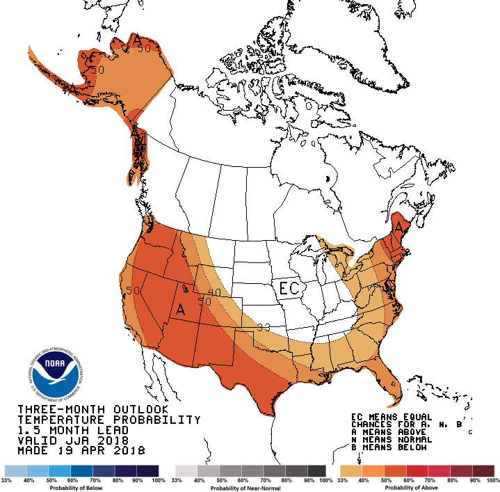
The latest spring/summer forecast for North Carolina shows cool temperatures will linger for a bit. Here's a look at the next 3 months.


CHARLOTTE, NC — The National Weather Service and the Weather Channel have released new long-range forecast for the next three months, saying the start of May for North Carolina should continue to be chillier than normal. But by June, expect things to warm up as normal.
North Carolina, like much of the East Coast region, can expect temperatures to be cooler or close to average through May. With June, though, comes warmth. Temperatures will be normal and even above average temperatures at that time, according to the Weather Channel's predictions.
The Weather Service says that May should bring above-normal temperatures and precipitation overall, although the first half of the month will be cooler than normal.
Find out what's happening in Charlottefor free with the latest updates from Patch.
The three-month outlook forecast was released over the weekend by the Weather Channel, which predicts early summer will be like last year, when temperatures were "fairly tame," running near or slightly above average.
Here's a look at the Weather Channel's long-term forecast, month-by-month:
Find out what's happening in Charlottefor free with the latest updates from Patch.
- May: The East Coast can expect near-average or colder temperatures in May. The Southwest will likely experience another month of hotter-than-average temperatures.
- June: Much of the East Coast will see temperatures that are near or slightly above average.
- July: While there is the potential for "big-time" heat in much of the West in July, the Northeast will see temperatures that average or slightly above.
Click here to read the full three-month forecast from The Weather Channel.
For now, expect to see plenty of April showers.
Here is the week's full forecast:
Today (April 23)
Showers. Patchy fog after 2pm. High near 58. East wind 10 to 15 mph, with gusts as high as 24 mph. Chance of precipitation is 100%. New precipitation amounts between a half and three quarters of an inch possible.
Tonight
Showers. Patchy fog before 4am. Low around 55. Breezy, with an east wind 17 to 20 mph, with gusts as high as 32 mph. Chance of precipitation is 90%. New precipitation amounts between a half and three quarters of an inch possible.
Tuesday (April 24)
Showers likely and possibly a thunderstorm. Patchy fog between 9am and 11am. Otherwise, cloudy, with a high near 67. East wind 6 to 11 mph, with gusts as high as 18 mph. Chance of precipitation is 70%. New rainfall amounts between a quarter and half of an inch possible.
Tuesday Night
A 40 percent chance of showers. Mostly cloudy, with a low around 56. Light west northwest wind. New precipitation amounts of less than a tenth of an inch possible.
Wednesday (April 25)
A 20 percent chance of showers. Mostly sunny, with a high near 72. West northwest wind 3 to 6 mph.
Wednesday Night
Mostly cloudy, with a low around 54.
Thursday (April 26)
A 40 percent chance of showers after 8am. Mostly cloudy, with a high near 69.
Thursday Night
A 40 percent chance of showers. Mostly cloudy, with a low around 52.
Friday (April 27)
A 30 percent chance of showers before noon. Mostly sunny, with a high near 71.
Friday Night
A chance of showers between 1am and 3am. Partly cloudy, with a low around 51. Chance of precipitation is 30%.
Saturday (April 28)
Mostly sunny, with a high near 70.
Saturday Night
Mostly clear, with a low around 50.
Sunday (April 29)
Sunny, with a high near 74.
Patch Editor Deb Belt contributed
Image via Andrey Atanov /Shutterstock; graphic from the National Weather Service
Get more local news delivered straight to your inbox. Sign up for free Patch newsletters and alerts.