Weather
North Carolina Eyes Florence As Hurricane Season Nears Peak
As Hurricane Florence continues to brew in the Atlantic, forecasters are watching for potential impact on North Carolina coast.

CHARLOTTE, NC – As peak hurricane season approaches, forecasters are warily watching another storm making its way across the Atlantic and eyeing its potential impact along the North Carolina coast.
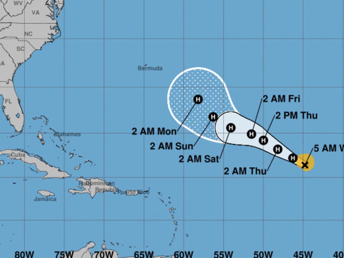
Hurricane Florence, though nowhere near land on Wednesday, could be headed towards Bermuda and, from there, possibly towards the east coast, according to AccuWeather .
"There is concern that Florence may get steered closer to Bermuda around Monday, Sept. 10 — the peak of hurricane season in the Atlantic," AccuWeather meteorologist Kristina Pydynowski said.
Find out what's happening in Charlottefor free with the latest updates from Patch.
"After nearing Bermuda, Florence may attempt to approach the eastern United States later that week," though Pydynowski added it was far too early to accurately predict the storm's path.
Tropical Storm Gordon made landfall in Mississippi Tuesday night, battering the area with heavy rain and brutal winds. It's expected to now make it's way north and east.
Find out what's happening in Charlottefor free with the latest updates from Patch.
Though it will be greatly weakened, the remnants of the storm could possibly lead to a gusty thunderstorm along the mid-Atlantic as the heavier rains pass through the Mississippi Valley into the interior Northeast, AccuWeather said.
Mid-September is considered the height of the Atlantic hurricane season, and AccuWeather is expecting activity to pick up this week.
"At this point of the hurricane season, ocean water temperatures in the tropical Atlantic are at their warmest point, while disturbances, known as tropical waves, roll frequently westward off the coast of Africa," said AccuWeather meteorologist Alex Sosnowski.
"Indications are that two to three new tropical systems may bud and develop in the eastern and central Atlantic this weekend into next week."
Here's the detailed forecast, courtesy of the National Weather Service:
Today (Sept. 5)
Scattered showers and thunderstorms, mainly after 1pm. Partly sunny, with a high near 90. Calm wind becoming east northeast around 6 mph in the afternoon. Chance of precipitation is 30%. New rainfall amounts of less than a tenth of an inch, except higher amounts possible in thunderstorms.
Tonight
Isolated showers and thunderstorms before 9pm, then isolated showers between 9pm and 11pm. Partly cloudy, with a low around 72. East wind around 5 mph becoming calm in the evening. Chance of precipitation is 20%.
Thursday (Sept. 6)
Mostly sunny, with a high near 90. Light east wind.
Thursday Night
Mostly clear, with a low around 72. East southeast wind around 5 mph becoming calm in the evening.
Friday (Sept. 7)
A 20 percent chance of showers and thunderstorms after 2pm. Mostly sunny, with a high near 90. Light and variable wind.
Friday Night
A slight chance of showers and thunderstorms before 8pm, then a slight chance of showers between 8pm and 9pm. Partly cloudy, with a low around 71. Chance of precipitation is 20%.
Saturday (Sept. 8)
A chance of showers between 10am and 2pm, then a chance of showers and thunderstorms after 2pm. Mostly sunny, with a high near 89. Chance of precipitation is 40%.
Saturday Night
Showers and thunderstorms likely. Mostly cloudy, with a low around 70. Chance of precipitation is 60%.
Sunday (Sept. 9)
Showers likely before 10am, then showers likely and possibly a thunderstorm between 10am and 2pm, then showers and thunderstorms likely after 2pm. Partly sunny, with a high near 84. Chance of precipitation is 60%.
Sunday Night
Showers and thunderstorms likely before 3am, then a chance of showers. Mostly cloudy, with a low around 70. Chance of precipitation is 60%.
Monday (Sept. 10)
A 40 percent chance of showers and thunderstorms. Partly sunny, with a high near 86.
Patch Editor Adam Nichols contributed
Main image via the National Hurricane Center
Get more local news delivered straight to your inbox. Sign up for free Patch newsletters and alerts.