Weather
Tropical Storm Watches Issued For Coast of Carolinas
The National Weather Service has issued a tropical storm watch for the coast of the Carolinas. Here's what you need to know.


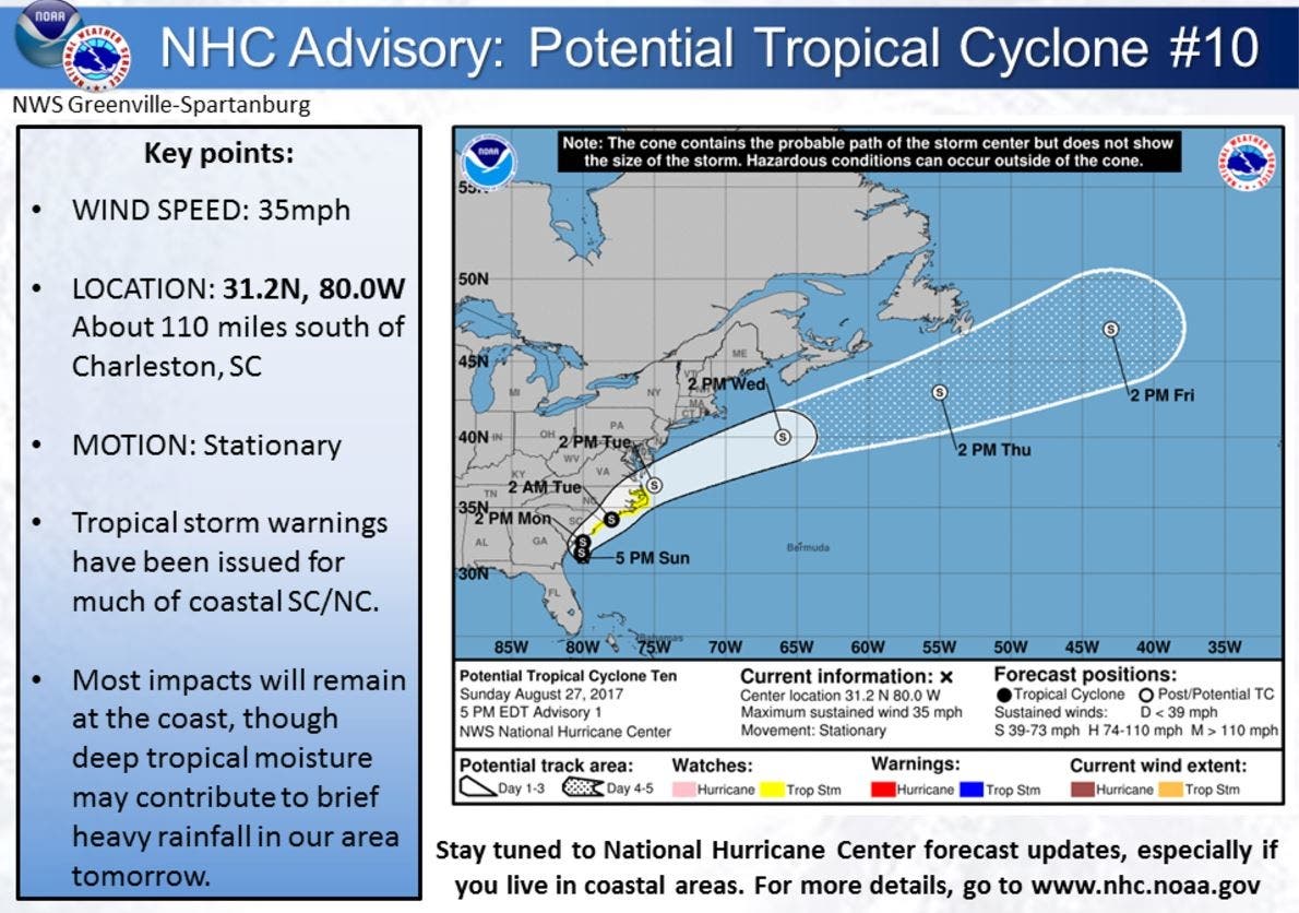
CHARLOTTE, NC -- A tropical storm watch was issued for the coast of North and South Carolina Sunday evening, according to the National Weather Service.
As of Sunday evening at 5 p.m., the potential cyclone was stationary off the Georgia coast about 110 miles south of Charleston with a wind speed of about 35 miles per hour. NWS meteorologists expect the storm to turn into a tropical depression or storm during the evening of Aug. 27 or Monday, Aug. 28.
The expected trajectory is to move north east up the coast of North Carolina and back out into the Atlantic Ocean, according to NWS predictions. (Get Patch real-time email alerts for the latest news in Charlotte — or other neighborhoods. And iPhone users: Check out Patch's new app.)
Find out what's happening in Charlottefor free with the latest updates from Patch.
Hurricane Season's Peak Nears
The Atlantic hurricane season technically lasts from June 1 to Nov. 30, but forecasters call the period between mid-August and mid-October the “season within the season.” This eight-week period “is often the most active and dangerous time for tropical cyclone activity,” according to the National Oceanic and Atmospheric Administration.
Find out what's happening in Charlottefor free with the latest updates from Patch.
The eight-week period from August to October is historically responsible for major spikes in tropical weather activity, NOAA said. In fact, it accounts for roughly 78 percent of all tropical storm days on record. It is also the period when 87 percent of the category 1 and 2 hurricane days on record occurred. In addition, this period is responsible for “a whopping 96 percent of the major (category 3, 4 and 5) hurricane days.”
So, what makes this eight-week stretch so special?
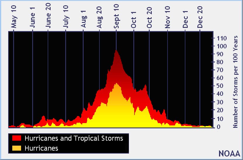
“Tropical waves are coming off of the coast of Africa roughly every three days, and the very early and late parts of the year provide additional types of potential seedlings,” NOAA’s website explains.
Other environmental conditions during the peak tend to be more conducive for storm development, as well. The factors that align during the peak period include wind, temperature and moisture. Wind shear that might rip disturbances apart in May, for example, tend to weaken by late August, NOAA said.
“This minimum in the shear combines with favorable thermodynamics – ocean temperatures in the deep tropics that increase with each day of summer sun, warmer air temperatures, and increasing atmospheric moisture,” NOAA explained. “When the dynamics and thermodynamics are in sync, as they often are from mid-August through early October, disturbances like African tropical waves can easily strengthen.”
Conditions gradually become less ripe for development in mid-October when increased wind shear tends to reappear and water and air temperatures cool.
Meanwhile, a second area of disturbed weather that was under watch in the Atlantic Ocean fizzled out. As of 11 a.m. Monday, that system dissipated in the area between the Cabo Verde Islands and the Lesser Antilles. The storm had only been given only a 10 percent chance of developing more over the next five days.
Residents readying for the ongoing season can get tips and advice on the federal government’s Ready.gov website.
Patch Editor Sherri Lonon contributed to this report.
Graphics courtesy of the National Hurricane Center
Keep up with more local news by liking Charlotte Patch on Facebook:
Get more local news delivered straight to your inbox. Sign up for free Patch newsletters and alerts.