Weather
Winter Storm Watch: Here’s When Snow, Sleet Will Start In NC
A major winter storm is expect to dump up to about a foot of snow in the piedmont and western NC, according to the National Weather Service.


CHARLOTTE, NC — A winter storm watch is in effect beginning Saturday evening through Monday morning as North Carolina braces for what forecasters are saying is a major winter storm that could dump up to about a foot of snow in the piedmont and western North Carolina.
The storm is the anticipated result of cold high pressure along the East Coast colliding with moist low pressure coming out of the Gulf of Mexico Saturday night leading into Sunday morning, forecaster said.
“Moderate to heavy precipitation will fall as a mixture of snow, sleet, and freezing rain across theRegion,” the National Weather Service said Friday morning. “Accumulations are expected to be greatest in western North Carolina.”
Find out what's happening in Charlottefor free with the latest updates from Patch.
What Does This Mean For The Charlotte-Metro Region?
According to NWS, heavy mixed precipitation of snow and sleet could have accumulations from 3 inches to 11 inches, along with a light glazing of ice, beginning Saturday night and stretching into Monday morning.
Find out what's happening in Charlottefor free with the latest updates from Patch.
“Travel could become very difficult or even impossible. Road conditions could deteriorate as early as Saturday evening, with highway travel continuing to be impacted through early next week. Visibility may drop to less than a half mile during periods of heavy snow. Widespread, prolonged power outages are possible,” NWS said.
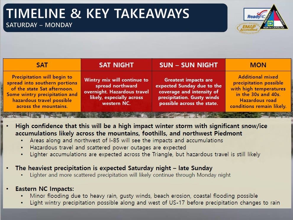
In a warning to residents, North Carolina Emergency Management said scattered power outages are expected.
The heaviest precipitation of snow and sleet is expected Saturday night through late Sunday, during which time gusty winds are possible across the state, NCEM said. And while the western and piedmont regions of the state are expected to receive the brunt of the winter weather, eastern North Carolina could see minor flooding due to heavy rain, high wind gusts and even possible coastal flooding. A light wintry precipitation is also possible along and west of US-17 before it turns into rain, NCEM said.

We're getting ready to help keep North Carolina moving! #NCWX 846 employees 276 trucks 204,500 gallons of brine placed pic.twitter.com/PQ2ZVFXQkc
— NCDOT (@NCDOT) December 7, 2018
Here is the National Weather Service’s forecast through early next week:
Today (Dec. 7)
Partly sunny, with a high near 50. North northeast wind around 5 mph becoming calm in the afternoon.
Tonight
Mostly cloudy, with a low around 35. Light northeast wind.
Saturday(Dec. 8)
A 50 percent chance of rain, mainly after 9am. Cloudy, with a high near 40. Northeast wind 3 to 6 mph. New precipitation amounts between a tenth and quarter of an inch possible.
Saturday Night
Rain before 3am, then snow. Low around 31. Northeast wind 7 to 14 mph, with gusts as high as 21 mph. Chance of precipitation is 90%. New snow accumulation of 3 to 5 inches possible.
Sunday (Dec. 9)
Snow, freezing rain, and sleet before 1pm, then sleet between 1pm and 4pm, then rain or freezing rain after 4pm. High near 33. Northeast wind around 16 mph, with gusts as high as 24 mph. Chance of precipitation is 100%.
Sunday Night
Rain, freezing rain, and sleet likely before 2am, then snow and sleet likely between 2am and 4am, then snow likely after 4am. Cloudy, with a low around 31. Chance of precipitation is 70%.
Monday (Dec. 10)
Sleet likely before 9am, then a chance of rain and sleet between 9am and 5pm, then a chance of rain, snow, and sleet after 5pm. Cloudy, with a high near 38. Chance of precipitation is 60%.
Monday Night
Mostly cloudy, with a low around 27.
Tuesday (Dec. 11)
Mostly sunny, with a high near 41.
(For more news like this, find your local Patch here. If you have an iPhone, click here to get the free Patch iPhone app; download the free Patch Android app here.)
Image courtesy of North Carolina Emergency Management
Get more local news delivered straight to your inbox. Sign up for free Patch newsletters and alerts.