Community Corner
Eagle Creek Fire: Snow Way! Crews Battling Eagle Creek Fire Get Help From Mother Nature
A cold front will bring natural fire suppression to the Columbia River Gorge this week, as state fire officials prepare for egress.


UPDATE Sept. 18 at 1:20 p.m.: All evacuation orders previously issued in Multnomah County have been lifted.
CASCADE LOCKS, OR — A cold front that moved in Sunday turned into rain overnight and snow at Timberline Lodge by Monday morning, bringing much-needed relief to Eagle Creek firefighting crews in the Columbia River Gorge. And while rain is a boon in many ways, it also brings with it new dangers for the remaining 600-plus firefighters on the ground.
According to the Oregon State Fire Marshal, terrain damaged by the Eagle Creek Fire — which has burned nearly 48,400 acres — is now susceptible to landslides, falling trees and falling rocks. Forecasters with the National Weather Service — Portland Office (NWS) have issued a flash flood warning for the fire area beginning Monday, though the heaviest rains aren't expected until Tuesday and Wednesday.
Find out what's happening in Greshamfor free with the latest updates from Patch.
The burn-scarred forest, now lacking its formerly lush vegetation, could cause increased runoff, initiating mud- and landslides as well as debris flows in the forms of flash floods, NWS officials said.
Late last week, Oregon Department of Transportation officials reopened Interstate-84's westbound lanes; eastbound lanes, however, remain closed due to the threat of falling timber and rocks. Remaining fire crews, now numbering 626, will focus efforts on mop up and ensuring the fire doesn't do anything unexpected.
Find out what's happening in Greshamfor free with the latest updates from Patch.
WATCH: Operations Section Chief Rick Miller provides what he expects will be the final Eagle Creek Fire update.
Fire marshal crews called Monday their last day for Eagle Creek Fire updates, predicting the weather event this week to bring the death knell for the two-week-old fire — which began Sept. 2 after a 15-year-old boy from Vancouver, Washington, allegedly threw a firecracker into the dry Eagle Creek Canyon, according to Oregon State Police.
The fire spread quickly over its first weekend and throughout its first week, growing exponentially, it seemed, every day. Crews battled the fire back on its westside, particularly where it threatened to affect the Bull Run watershed, Portland's primary drinking water source. Over the past few days, the fire pushed across Herman Creek on the Eastside and spread downhill toward I-84, prompting Hood River County officials to upgrade evacuation alerts in some areas.
Nearby residents and even folks in the Portland metro area may continue to see smoke emanate from the gorge as the last spot fires are extinguished this week, but for the most part it appears the Eagle Creek Fire is coming to its end.
Evacuation orders at this time appear to remain in place. Evacuated residents should continue to monitor conditions, however, as evacuation alerts will likely change again throughout this week.
Evacuation levels in Hood River and Multnomah counties changed near the end of last week and again on Monday.
From the Hood River County Sheriff's Office:
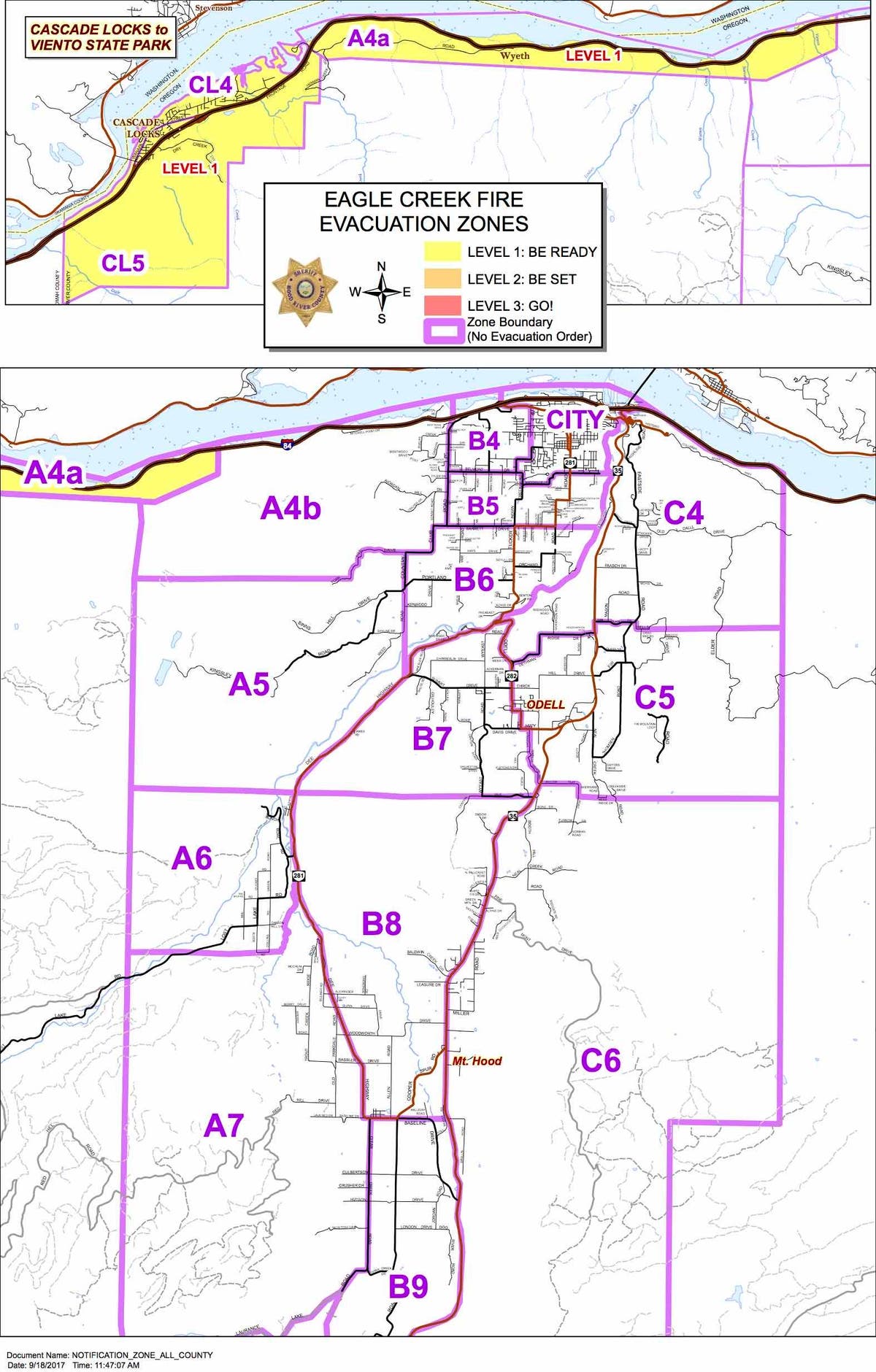
The Hood River Valley will have all evacuation levels lifted. This means zones A4b, A5, A6, A7, B4, B5, B6 and B7 return to normal, pre-fire status.
Due to the flash flood advisory for the I-84 corridor, exit 56 all the way west to the county line will remain on Level One notice. This means that the Cascade Locks area, as well as Wyeth and Viento, need to remain ready for the possibility of evacuation.
Residents and travelers should also be aware of the potential dangers associated with the flash flood advisory. Vigilance should be maintained, as rocks, trees, and debris could threaten the roadway and some populated areas. All evacuation notices for the public lands around Lost Lake are being lifted. However, all Hood River County Forestlands, Roads, and Trails are closed, as are all U.S. Forestlands north of Mt. Hood and west of Highway 35. Recreational use on these lands is prohibited at this time. Anyone found in this area could face citation, and anyone who enters these areas in violation of the closure may not receive search and rescue assistance if needed.
The latest information on evacuation levels continues to be found at hoodriversheriff.com and on our Facebook and Twitter pages. The information lines are 541-387-6911 (English) and 541-387-7080 (Spanish).Multnomah County officials on Sept. 15 altered the evacuation levels on the metro region's Eastside.
According to the Multnomah County Sheriff's Office, all evacuation orders were lifted shortly after 1 p.m. Monday:
A combination of successful firefighting efforts and recent rains has allowed fire crews to continue making progress on the fire lines along the west side of the Eagle Creek Fire.
Effective immediately, ALL evacuation orders in Multnomah County have been lifted. Residents are reminded that with the recent fire and subsequent rains, the dangers of falling trees, rocks, debris flows, landslides and flooding is greatly increased in the Columbia River Gorge. If you see landslide activity where there is no immediate danger, please report it to (503) 823-3333. In the event of an emergency, please dial 911 immediately.
Access to the communities of Dodson, Warrendale, Bridal Veil, and Latourell is limited to residents only, as a result of road closures on both the Historic Columbia Highway and eastbound I-84. Residents in these communities should report to the Troutdale Police Community Center (234 SW Kendall Ct. Troutdale, OR) to receive instructions and permits to access closed roadways.
All United States Forest Service lands and Oregon State Parks in the Gorge remain closed at this time. Access to these areas continues to be prohibited. In addition, Larch Mountain Road is closed above Red Elder Drive and there is no access to Sherrard Point.
MCSO would like to remind members of the public that anyone accessing closed areas may be subject to criminal investigation. MCSO wishes to thank our community for their patience and resilience throughout this challenging event.
Image via National Weather Service — Portland Office
Get more local news delivered straight to your inbox. Sign up for free Patch newsletters and alerts.