Community Corner
Eagle Creek Fire: State Reopens I-84 Westbound (sort of); Multnomah County Evacuations Downgraded
Crews reached 28 percent containment heading into Friday as the fire grew to more than 41,500 acres burned.

CASCADE LOCKS, OR — As the Eagle Creek Fire surpassed 41,500 acres burned Thursday, fire crews in the Columbia River Gorge also achieved 28 percent containment. By Thursday evening, state officials were able to safely reopen the westbound lanes of Interstate-84, giving commuters who've had to take Washington's Lewis and Clark Highway detour reason to celebrate.
Celebrations will need to be restrained, however, during the closure of westbound lanes Saturday from 6 a.m. to 11 a.m. Oregon Department of Transportation officials on Friday said the lanes will need to be re-closed temporarily while crews remove large trees that are endangering the roadway from Hood River to Troutdale. Some trees have already been removed, officials said, but other that still need felled could damage roadway barriers. The westbound lanes will be reopened as soon as it's safe to do so, officials said.
There has been no official word on when I-84's eastbound lanes will be reopened.
Find out what's happening in Greshamfor free with the latest updates from Patch.
All exits between Hood River and Troutdale remain closed, and commuters are asked to proceed through the area with extreme caution.
Find out what's happening in Greshamfor free with the latest updates from Patch.
The fire grew rapidly in its first week, and continues to grow as it nears two weeks old. The fire marshal said aircraft dumped nearly 100,000 gallons of water on the fire Thursday, an effort which was also aided by rapidly cooling temperatures in the Pacific Northwest. Rain expected this weekend is also likely play a role in fire suppression efforts.
Crews on Friday will focus on the fire's northeast corner, as burnouts are performed between Cascade Locks and Mitchell Point. The fire marshal said resources will work hard to protect the communities at-risk in those areas.
On the west side, the marshal said, the fire is most active in Bell Creek. Crews and helicopter bucket drops will work to cool hotspots and construct hand lines in that area on Friday, the fire marshal said.
Crew numbers remain at more than 950 heading into the weekend.
Evacuation levels in Hood River and Multnomah counties changed Thursday afternoon and Friday morning.
From the Hood River County Sheriff's Office:
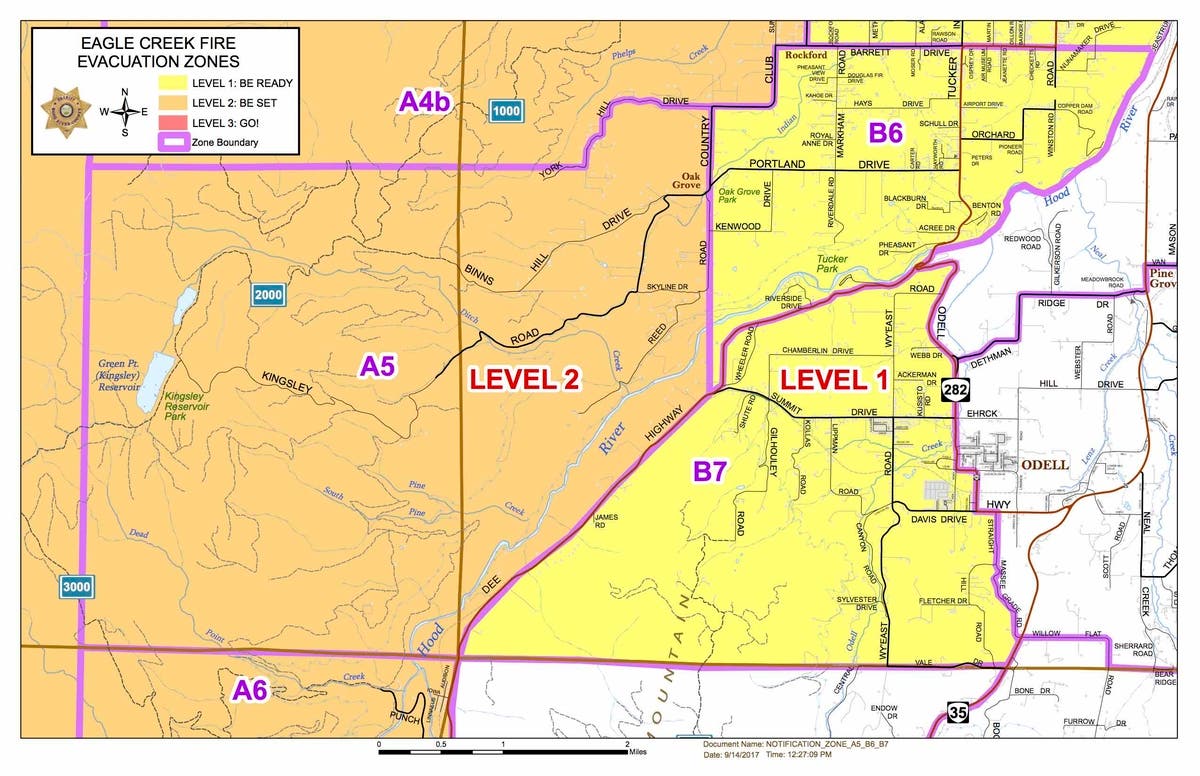
Zones A5 and A6 are being placed on Level Two evacuation notices. Adding in the current Level 2 zone of A4b, the new boundaries for Level 2 will be defined as follows: The northern boundary will be the Columbia River, and the southern boundary will be the south end of Collins Road in Dee. The eastern boundary runs south from 430 Country Club and follows Country Club down to Reed Road, then runs overland due south to Hwy. 281, continuing along 281 to milepost 12.5, then following the Middle Fork of the Hood River until it comes parallel with the south end of Collins Road. The western boundary includes the Kinglsey Reservoir area.
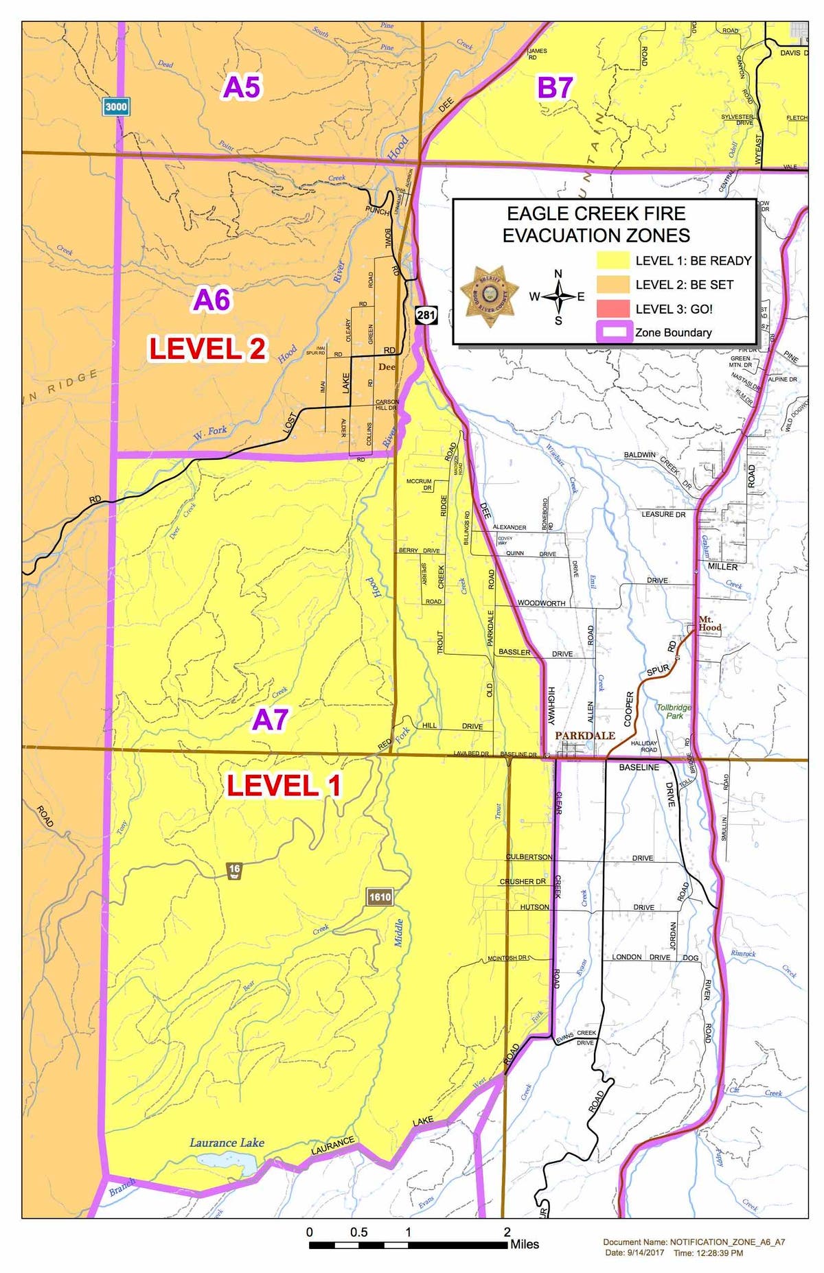
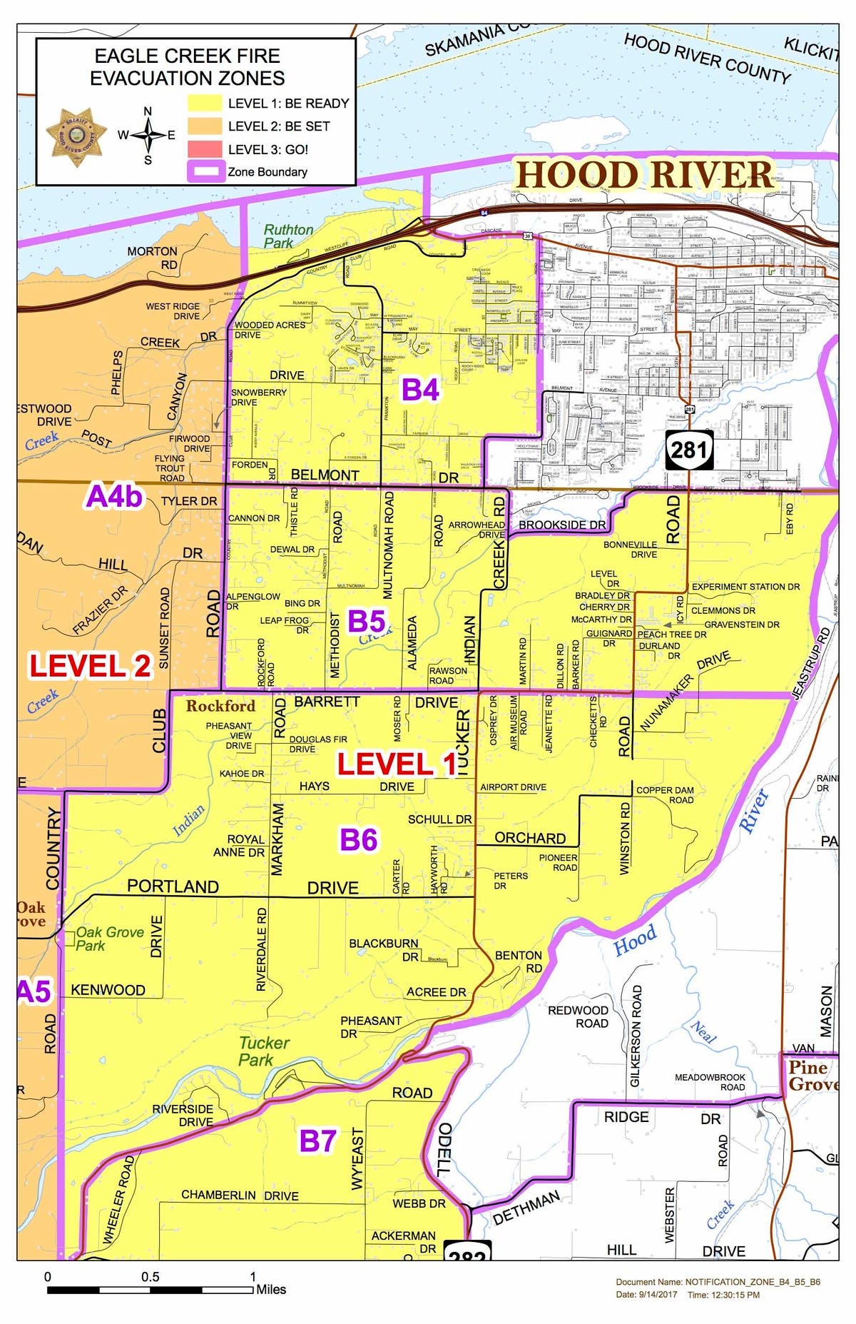
Zones A7, B4, B5, B6 and B7 are now being placed on Level One evacuation notice.
A7: The northern boundary of this zone begins at the intersection of Highway 281 (Dee Highway) and the Middle Fork of the Hood River (Milepost 12.5) and runs down to the south end of Collins Road in Dee. The southern boundary follows Laurance Lake Road from Clear Creek Road out past Laurance Lake. The eastern boundary follows 281 south to Clear Creek and then south to Laurance Lake.
B4: The northern boundary of this zone is the Columbia River and the southern boundary is Belmont Drive. The eastern boundary is Rand Road running down to the May Street intersection. The line then continues due south until it reaches Belmont Drive in the 2600 Block area. The western boundary is Country Club Road.
B5: The northern boundary of this zone uses Belmont, Brookside and Elliot. The southern boundary uses Barrett Drive, running on a straight line through Tucker Road, all the way to the Hood River. The Hood River is the eastern boundary, and Country Club Road is the western boundary.
B6: The northern boundary of this zone uses Barrett Drive running east-west from Country Club to the Hood River. The southern-eastern boundary follows the Hood River until it reaches Highway 281 (Dee Highway), then follows 281 until Summit Drive. The Hood River is the eastern boundary, and the western boundary is defined by Country Club, beginning at the Barrett intersection, then following it south to Reed Road, then following that line due south until it intersects with 281 at Summit.
B7: The north-western boundary of this zone begins at the Highway 281 (Dee Highway) and Highway 282 (Odell Highway) junction and follows 281 down to mile post 10.5. The southern boundary follows a straight line east-west using Central Vale Drive. The eastern boundary follows Highway 282 (Odell Highway) until it reaches Straight Hill Road, south to Massee Grade, then intersecting with Highway 35 until Central Vale Drive.
The Cascade Locks area remains at Level Two notice, and the A4a zone running along the I-84 corridor from Exit 47 to Exit 56 remains at Level Three.
The new alterations, the second batch in two days, were reportedly due to new spot fires that began in Herman Creek and spread to the ridges east of Gorton Creek and Shellrock Mountain, Hood River County officials said.
Multnomah County officials on Friday altered the evacuation levels on the metro region's Eastside.
According to the Multnomah County Sheriff's Office, the following changes have been made:
The sheriff's office downgraded all Level 3 evacuation orders to Level 2 beginning at 12 p.m. Sept. 15. Level 2 asks that residents remain on alert for changing conditions, but does allow evacuated residents to return home. Anyone returning home is asked to visit the re-entry center at Corbett Community Church, 34309 N.E. Mershon Rd. in Corbett.
The reduced evacuation level will apply to the communities and areas of:
- Dodson
- Warrendale
- Bridal Veil
- East Historic Columbia River Highway: East of Alex Barr Road, addresses in the 43800 block and higher
- Larch Mountain Road: East of Brower Road, addresses in the 45800 block and higher
- All of Brower Road, including Toll Road
- E Haines Road: addresses in the 43800 block and higher
Level 2 (Be Set) evacuation orders remain in place for:
- Latourell
- Larch Mountain Road: West of Brower Road, addresses in the 45700 block and lower, including Salzman Road and Alder Meadows Road
- E Haines Road: addresses in the 43700 block and lower (towards Larch Mountain Road)
- Corbett
- Springdale
- Troutdale: addresses East of the Sandy River
And Level 1 (Get Ready) evacuation notices have been lifted for all areas of Troutdale West of the Sandy River, meaning there currently are no communities in a Level 1 evacuation.
Residents in the areas downgraded from Level 3 to Level 2 are asked to report to a re-entry center located at Corbett Community Church, 34309 N.E. Mershon Rd. in Corbett, sheriff's officials said.
Because residents moving from a Level 3 to a Level 2 are still asked to Be Set, we are requesting that only household pets return with their owners, and that large livestock and horses remain out of these areas until evacuation orders are lifted. The Sheriff’s Office understands the importance of getting our residents back into their homes and neighborhoods as quickly as possible. Over the coming days, we will continue to work with fire officials to examine possible re-entry into additional portions of the remaining Level 3 communities. For those residents still under a Level 3 evacuation notice, thank you for your continued patience and understanding. Questions regarding evacuations in Multnomah County can be directed to 211. If you are a resident of Hood River County, please continue to monitor updates from the Hood River County Sheriff’s Office. For access to the current evacuation map, please visit multco.us.
More information will be available for gorge-area residents at a community meeting scheduled for 12 p.m. Saturday, Sept. 16, at Hood River High School.
This post was updated with closure information for Interstate-84's westbound lanes from 6 a.m. to 11 a.m. Saturday.
Image via Multnomah County Communications, Flickr
Get more local news delivered straight to your inbox. Sign up for free Patch newsletters and alerts.