Weather
Another Round Of Heavy Storms In Forecast For Eastern PA Wednesday
As another day of potential floods loom over the Philadelphia region, dangerous severe heat is also moving into the area, forecasters said.

The threat of powerful storms loom over the greater Philadelphia region for the third consecutive day Wednesday, and could bring severe rain that triggers flash floods, the National Weather Service said.
While severe storms were well south of the region Tuesday, forecasters say that most of eastern Pennsylvania and parts of western New Jersey and Delaware are within the highest risk zone Wednesday.
While some rain and thunderstorms are possible after 1 p.m., the bulk of the storms Wednesday are expected in the evening hours, from 8 p.m. and continuing overnight into Thursday.
Find out what's happening in Across Pennsylvaniafor free with the latest updates from Patch.
Up to one to two inches of rain could fall per hour, and localized amounts of two to four inches are possible in the strongest storms, forecasters said.
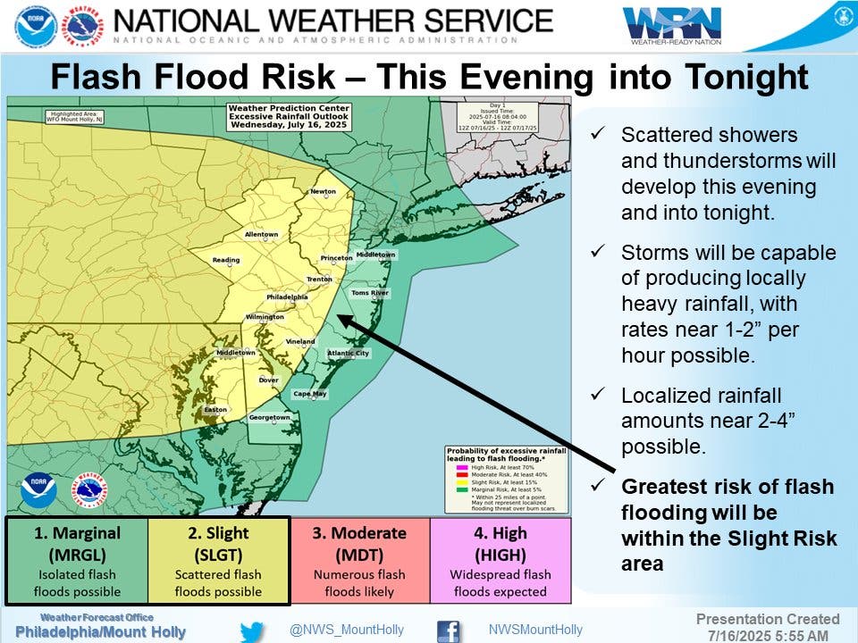
Specifically, flash flooding could target urban and poor drainage areas, and areas that historically receive flooding near creeks and streams are at risk. Road closures and power outages are also possible, forecasters warned.
Find out what's happening in Across Pennsylvaniafor free with the latest updates from Patch.
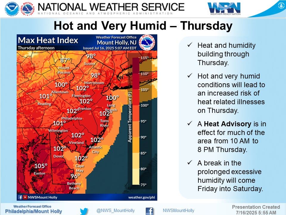
The storms will be accompanied Wednesday and into Thursday by extreme heat. The high Wednesday is 91, but it will only get worse. A heat advisory has been issued for the entire Philadelphia region for 10 a.m. to 8 p.m. Thursday, and the heat index is expected to exceed 100 throughout the area.
Another round of storms is in the forecast for Thursday, though the National Weather Service categorizes the risk from the rain and thunder in its lowest threat level.
The severe weather and heat is likely to break on Friday, with less humidity and a lower chance of any storms.
Here's the full forecast, according to the National Weather Service:
Wednesday
A chance of showers and thunderstorms after 1 p.m. Partly sunny, with a high near 91. Calm wind becoming southwest around 5 mph in the afternoon. Chance of precipitation is 50 percent. New rainfall amounts between a tenth and quarter of an inch, except higher amounts possible in thunderstorms.
Wednesday Night
Showers and thunderstorms likely, mainly before 8 p.m. Mostly cloudy, with a low around 75. Southwest wind around 5 mph. Chance of precipitation is 60 percent. New rainfall amounts between a tenth and quarter of an inch, except higher amounts possible in thunderstorms.
Thursday
A chance of showers, with thunderstorms also possible after 11 a.m. Partly sunny, with a high near 92. Heat index values as high as 102. Southwest wind 5 to 10 mph. Chance of precipitation is 40 percent. New rainfall amounts of less than a tenth of an inch, except higher amounts possible in thunderstorms.
Thursday Night
A chance of showers and thunderstorms, mainly before 8 p.m. Partly cloudy, with a low around 77. Southwest wind around 5 mph. Chance of precipitation is 30 percent. New rainfall amounts of less than a tenth of an inch, except higher amounts possible in thunderstorms.
Friday
A slight chance of showers and thunderstorms after 2 p.m. Mostly sunny, with a high near 88. Northwest wind around 5 mph. Chance of precipitation is 20 percent.
Friday Night
Partly cloudy, with a low around 69.
Get more local news delivered straight to your inbox. Sign up for free Patch newsletters and alerts.


