Weather
Another Weekend Storm Set To Drench PA: See Latest Details
Forecasters say conditions will move from sunny and dry to stormy and rainy, in time for another wet weekend. See the latest:

PENNSYLVANIA – Fall weather is settling in to the Philadelphia area, and forecasters say conditions will move from dry to stormy in time for the weekend. This means another rainy, windy weekend for southeast Pennsylvania residents as two separate low systems affect the region.
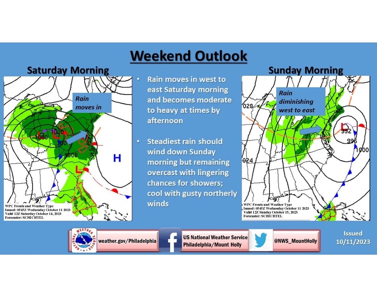
Wet, windy weather is predicted to affect the region beginning on Saturday, and could last until midday Sunday, according to the National Weather Service. Northwest winds will increase, as well, possibly gusting near 40 miles per hour or higher near the coast.
The rainy weekend pattern has been the norm for major East Coast cities in the past few months: There has been at least a trace of rain recorded 8 out of the past 10 weekends in New York City and Philadelphia, Weather Channel meteorologist Orelon Sidney said.
Find out what's happening in Across Pennsylvaniafor free with the latest updates from Patch.
As of Tuesday, the National Weather Service and the Weather Channel predict that between 1 and 2 inches of rain will fall over the weekend. AccuWeather forecasters said low clouds, patchy fog, and breezy conditions may cause airline delays in Philadelphia and and other regional airports.
“Enough rain will fall to bring a more typical risk of flooding in the Northeast's poor drainage areas this weekend,” added AccuWeather forecasters.
Find out what's happening in Across Pennsylvaniafor free with the latest updates from Patch.
The National Weather Service said that weather through Friday will be dry, with a mixture of sun and clouds, and temperatures around average. A primary surface low will push a warm front into the region, with rain arriving “sometime Friday night or early Saturday,” based on how the system's timing unfolds.
This primary low will weaken by late day Saturday, as a secondary low is expected to take shape to the south, likely over North Carolina or Virginia. This low is likely to track northeast off the coast Saturday night into Sunday.
“This means that rain should continue into, if not right through Sunday,” NWS forecasters said.
“Northeast winds may also become quite strong along the coast by Saturday night into Sunday as the low approaches and moves offshore,” the National Weather Service said. “There is the potential for gusts near the coast of 40 mph if not higher.”
Unsettled conditions will continue, with clouds and the chance of rain lingering into Monday or Tuesday, forecasters said.
Here is a look at the forecast this weekend for southeast Pennsylvania, from the National Weather Service:
Friday: Mostly sunny, with a high near 65. North wind around 5 mph.
Friday Night: A chance of rain after 2am. Mostly cloudy, with a low around 49. Chance of precipitation is 30 percent. New precipitation amounts of less than a tenth of an inch possible.
Saturday: Rain, mainly after 8am. High near 58. Chance of precipitation is 90 percent.
Saturday Night: Rain. Low around 49. Chance of precipitation is 90 percent.
Sunday: Rain likely, mainly before 8am. Mostly cloudy, with a high near 59. Chance of precipitation is 60 percent.
Sunday Night: A chance of showers. Mostly cloudy, with a low around 46. Chance of precipitation is 30 percent.
Get more local news delivered straight to your inbox. Sign up for free Patch newsletters and alerts.


