Weather
First Rain In Weeks Enters Philly-Area Forecast: See Timing, Details
Extremely dry conditions have elevated the risk of lethal and destructive wildfires, while also spurring drought conditions in the region.


PENNSYLVANIA — After weeks of severe drought conditions in much of eastern Pennsylvania, there could finally be a glimmer of relief on the horizon.
The first rainfall in weeks is now in the forecast for most of the southeastern portion of the state, the National Weather Service said.
The greater Philadelphia area has not seen measurable rainfall since Sept. 28, according to the agency.
Find out what's happening in Across Pennsylvaniafor free with the latest updates from Patch.
The lack of precipitation, coupled with near-record temperatures for late October and early November, has led to an elevated fire danger throughout the Delaware Valley. Wildfires constantly threaten, and burn bans — and even calls for voluntary water conservation — have been issued as a result.
The dry conditions will persist through Saturday, but a small storm front will arrive early Sunday, potentially bringing with it some light showers. There is only a 20 to 40 percent chance of rain around the region in the morning, however, with showers much more likely in the afternoon, when the likelihood of precipitation reaches 80 percent.
Find out what's happening in Across Pennsylvaniafor free with the latest updates from Patch.
Cumulative totals will be minimal. But the weekend will likely bring an end to a dry period the likes of which much of the Delaware Valley has never seen before at this time of the year.
"Looking ahead, there will be some opportunities for rainfall in the coming weeks, but the overall pattern will remain progressive in the sense that any rainfall is likely to be brief and probably not excessive," AccuWeather's senior meteorologist Dave Dombek said.
Sunday's rainfall is not likely to be sufficient enough to impact the drought conditions.
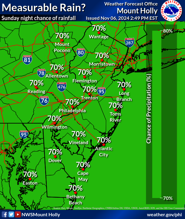
"Chances and confidence are increasing for a widespread measurable rainfall Sunday night!" the National Weather Service's Mt. Holly, New Jersey station shared. "Anything from (a tenth to a half of an inch) could be in the cards. This will NOT put any meaningful dent in the drought, but we'll certainly take anything we can get."
According to the National Drought Mitigation Center, all of southeastern Pennsylvania remains within the "moderate drought" classification.
See the full forecast below, according to the National Weather Service:
Thursday
Mostly sunny, with a high near 78. Northwest wind around 10 mph, with gusts as high as 20 mph.
Thursday Night
Clear, with a low around 46. North wind around 5 mph becoming calm in the evening.
Friday
Sunny, with a high near 70. Breezy, with a light west wind increasing to 15 to 20 mph in the morning.
Friday Night
Clear, with a low around 45. North wind around 10 mph, with gusts as high as 20 mph.
Saturday
Sunny, with a high near 59. North wind 5 to 10 mph.
Saturday Night
Partly cloudy, with a low around 38.
Sunday
A chance of showers after 1 p.m. Mostly cloudy, with a high near 61. Chance of precipitation is 30 percent.
Sunday Night
Showers. Low around 54. Chance of precipitation is 80 percent.
Veterans Day
Mostly sunny, with a high near 70.
Monday Night
Mostly clear, with a low around 48.
Tuesday
Sunny, with a high near 63.
Tuesday Night
Mostly clear, with a low around 42.
The U.S. Drought Monitor is jointly produced by the National Drought Mitigation Center at the University of Nebraska-Lincoln, the United States Department of Agriculture, and the National Oceanic and Atmospheric Administration.
Get more local news delivered straight to your inbox. Sign up for free Patch newsletters and alerts.


