Weather
Timeline For Severe Weather Tuesday In Eastern PA
Damaging winds and flooding could cause chaos on local roadways during the commute Tuesday, forecasters said.


The likelihood of flooding and excessive rainfall has increased Tuesday in the greater Philadelphia region, with anywhere from 1.5 to 3 inches of precipitation possible throughout the day.
The storm will arrive at 2 p.m. and continue until around 10 p.m.
Most of the five-county region is with the "moderate risk" of flash flooding, meaning there is at least a 40 percent chance, forecasters said. A flood watch is place until 2 p.m. Wednesday.
Find out what's happening in Across Pennsylvaniafor free with the latest updates from Patch.
"Flash flooding of urban and poor drainage areas, creeks, and streams is possible," the National Weather Service said. "Flooding could result in road closures."
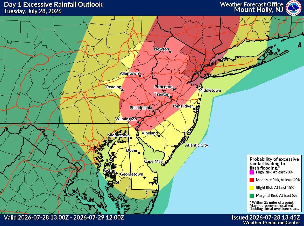
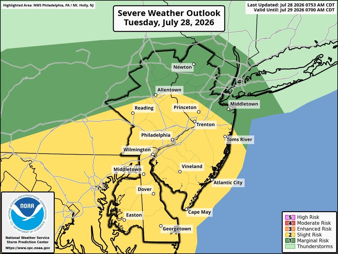
In addition to heavy rain, thunderstorms could produce damaging winds, and tornadoes are once again a possibility, according to the forecast.
Find out what's happening in Across Pennsylvaniafor free with the latest updates from Patch.
Power outages, downed trees, and road closures could all result from the storms. The Tuesday evening commute could be significantly impacted.
"Thunderstorms do not have to be severe to produce frequent lightning strikes and heavy downpours that can lead to water on roads and poor visibility for motorists," Accuweather Senior Meteorologist Alex Sosnowski said Tuesday.
Drivers are urged to monitor forecasts closely and to avoid driving through any standing water.
The National Weather Service places the region in the "slight risk" category 2 on Tuesday. Monday was category 1.
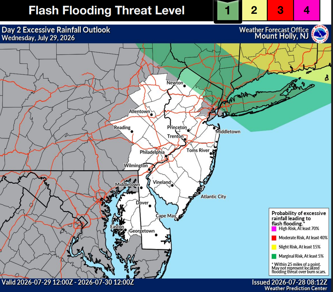
The flash flooding threat will persist into Wednesday, as grounds will be very saturated from the heavy rainfall Tuesday.
Here's the forecast over the coming week in the greater Philadelphia area:
Tuesday
A chance of showers and thunderstorms before noon, then showers likely and possibly a thunderstorm between noon and 5 p.m., then showers and thunderstorms likely after 5 p.m. Cloudy, with a high near 82. South wind around 10 mph, with gusts as high as 20 mph. Chance of precipitation is 70 percent. New rainfall amounts between three quarters and one inch possible.
Tuesday Night
Showers and thunderstorms before 11 p.m., then a chance of showers between 11 p.m. and 2 a.m. Low around 67. South wind 5 to 10 mph becoming west after midnight. Chance of precipitation is 80 percent. New precipitation amounts between a half and three quarters of an inch possible.
Wednesday
Mostly sunny, with a high near 82. West wind 5 to 10 mph.
Wednesday Night
A chance of showers and thunderstorms. Mostly cloudy, with a low around 67. West wind 5 to 10 mph. Chance of precipitation is 50 percent. New precipitation amounts between a tenth and quarter of an inch, except higher amounts possible in thunderstorms.
Thursday
A slight chance of showers, then a chance of showers and thunderstorms after 2 p.m. Partly sunny, with a high near 81. Northwest wind 5 to 10 mph. Chance of precipitation is 40 percent. New rainfall amounts of less than a tenth of an inch, except higher amounts possible in thunderstorms.
Thursday Night
A chance of showers and thunderstorms before 8 p.m. Partly cloudy, with a low around 66. Chance of precipitation is 30 percent. New precipitation amounts of less than a tenth of an inch, except higher amounts possible in thunderstorms.
Friday
Mostly sunny, with a high near 84.
Friday Night
Partly cloudy, with a low around 68.
Saturday
Mostly sunny, with a high near 87.
Saturday Night
Mostly cloudy, with a low around 70.
Sunday
A chance of showers. Partly sunny, with a high near 87. Chance of precipitation is 30 percent.
Sunday Night
A chance of showers. Mostly cloudy, with a low around 71. Chance of precipitation is 50 percent.
Monday
A chance of showers and thunderstorms. Partly sunny, with a high near 87. Chance of precipitation is 40 percent.
Get more local news delivered straight to your inbox. Sign up for free Patch newsletters and alerts.