Weather
Tornado, Thunderstorm Warning Issued In Parts Of Eastern PA
A second round of severe weather will hammer the region Tuesday. Timing, impacts, and more:

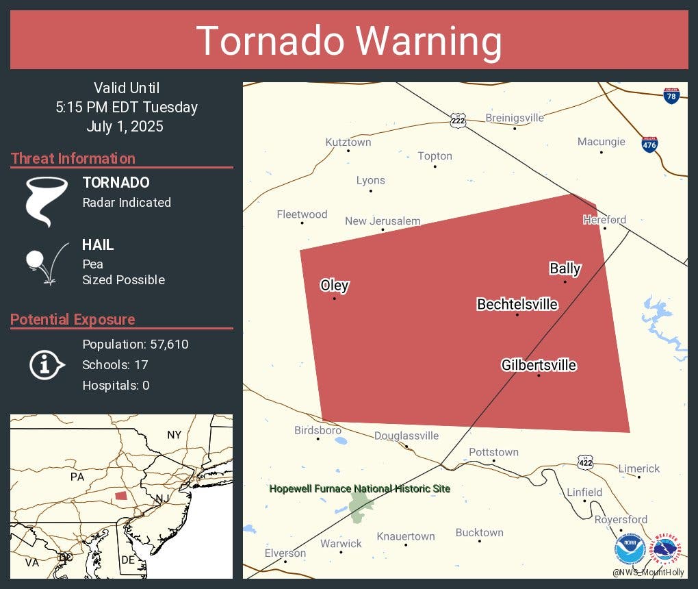
A tornado warning has been issued in parts of southeastern Pennsylvania as the powerful weather front continues moving through the region. The warning, covering parts of Montgomery and Berks counties, is in place until 5:15 p.m.
It was issued after a tornado was indicated on the radar, the National Weather Service said.
It comes as a severe thunderstorm watch issued for the entire greater Philadelphia region until 9 p.m. Thunderstorm warnings have popped up sporadically throughout the afternoon in parts of southern New Jersey and eastern Pennsylvania, though they have mostly skirted the five-county Philly area.
Find out what's happening in Across Pennsylvaniafor free with the latest updates from Patch.
Localized rainfall amounts could exceed four inches, officials said.
More than an inch of rain could fall, according to forecasters. The storm will bring a cool front after searing temperatures rise into the low 90s, with the heat index exceeding 100.
Find out what's happening in Across Pennsylvaniafor free with the latest updates from Patch.
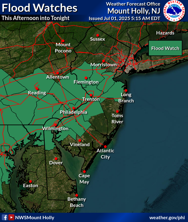
It comes a day after storms battered much of the area Monday late into the night, swelling the region's waterways and leading a flood watch to be declared for all of southeastern Pennsylvania Tuesday.
The flood watch is in effect from 2 p.m. Tuesday to 2 a.m. early Wednesday morning. The storm itself will likely arrive at around 2 p.m., and is expected to be more severe than the first round that hit on Monday.
"There has been an increase in the potential flood threat today especially over the urban corridor," the National Weather Service's Mt. Holly, New Jersey branch said in a statement. "Isolated to scattered severe thunderstorms and scattered to numerous flash floods will be possible."
The Weather Service has also increased the risk for excessive rainfall to "moderate," which is the agency's second most severe categorization. Monday's risk, for comparison, was "marginal," or the fourth and least severe risk level.
The heavy rain will be accompanied by thunderstorms and powerful gusts up to 60 miles per hour.
The wind could knock down trees and power lines, and potentially cause widespread power outages.
"Flooding downpours, hail and damaging wind gusts will be the primary threats in any severe thunderstorm that erupts," Accuweather meteorologist Peyton Simmers said. "These thunderstorms can slow down the evening commute along parts of the I-95 corridor including in New York City, Philadelphia and Washington, D.C."
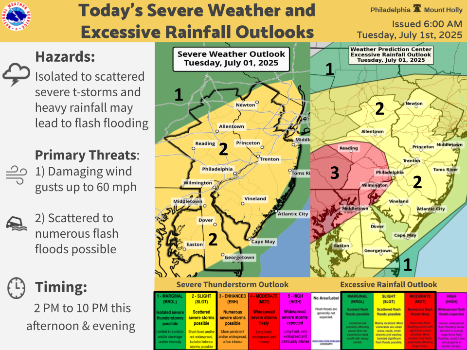
The storms will continue through around 10 p.m. Tuesday night, forecasters said.
The full forecast for the next few days is below:
Tuesday
Showers and thunderstorms likely, then showers and possibly a thunderstorm after 4 p.m. Some of the storms could produce heavy rainfall. High near 90. Southwest wind around 10 mph. Chance of precipitation is 80 percent. New rainfall amounts between a quarter and half of an inch possible.
Tuesday Night
Showers and possibly a thunderstorm. Some of the storms could produce heavy rainfall. Low around 72. West wind 5 to 10 mph. Chance of precipitation is 90 percent. New rainfall amounts between a quarter and half of an inch possible.
Wednesday
Showers and thunderstorms likely, mainly before 11 a.m. Mostly cloudy, with a high near 81. West wind around 5 mph. Chance of precipitation is 60 percent. New rainfall amounts of less than a tenth of an inch, except higher amounts possible in thunderstorms.
Wednesday Night
Partly cloudy, with a low around 69. Southwest wind around 5 mph becoming calm in the evening.
Thursday
Sunny, with a high near 87. Calm wind becoming west around 5 mph in the afternoon.
Thursday Night
Mostly clear, with a low around 67.
Get more local news delivered straight to your inbox. Sign up for free Patch newsletters and alerts.


