Weather
Heavy Rainfall, Flash Flooding Could Target Philly Region: See Latest
If the axis of heaviest rain moves more westward as the day progresses, we could see higher totals in southeastern Pennsylvania.


PENNSYLVANIA— Forecasters are warning of flash flooding in parts of the East Coast on Friday as a slow-moving coastal low approaches the region, and several southeastern Pennsylvania counties are under a coastal flood watch with rain expected to swell local waterways.
Around the Philadelphia metro area, forecasters are predicting between half an inch and 1 inch of rain in total as of the latest update; showers may be heavy as they move through the region, but are affecting the New York City metro more as of Friday morning.
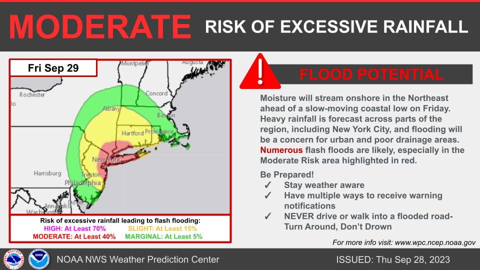
Forecasters say to expect a dreary day in southeastern Pennsylvania; there is a marginal risk for excessive rainfall in the region, meaning isolated flash flooding is possible, primarily affecting places that "can experience rapid runoff with heavy rainfall."
Find out what's happening in Across Pennsylvaniafor free with the latest updates from Patch.
And if the axis of heaviest rain pushes farther west as the day progresses, "places from the lower Hudson Valley southward across far eastern Pennsylvania and western New Jersey could be the focal point for flash flooding Friday, including the Philadelphia area," AccuWeather Senior Meteorologist Dan Pydynowski said.
Delaware, Philadelphia and Lower Bucks counties are under a coastal flood advisory until 5 p.m. Friday, per the National Weather Service. Chester, Bucks, Delaware, Montgomery, and Philadelphia counties are also under a hazardous weather outlook as the day progresses.
Find out what's happening in Across Pennsylvaniafor free with the latest updates from Patch.
"Water levels will remain elevated into the weekend, with minor or near minor tidal flooding possible with the high tides through at least Saturday," said the NWS.
Some weather models are calling for 9+ inches of rain from western Long Island, New York, to just north of New York City (including parts of Connecticut).
Rainfall rates of 1 inch per hour or more are possible at times, forecasters added as they warn of more localized flash flooding along local waterways, in urban areas, and in low-lying communities.
Here is a look at the forecast through Sunday in southeast Pennsylvania, from the National Weather Service.
Friday: A chance of showers and thunderstorms. Some of the storms could produce heavy rain. Patchy fog after noon. Otherwise, cloudy, with a high near 63. Northeast wind around 15 mph. Chance of precipitation is 40 percent. New precipitation amounts of less than a tenth of an inch, except higher amounts possible in thunderstorms.
Friday Night: A chance of showers. Patchy fog. Otherwise, cloudy, with a low around 57. North wind around 10 mph. Chance of precipitation is 40 percent. New precipitation amounts of less than a tenth of an inch possible.
Saturday: A slight chance of showers. Mostly cloudy, with a high near 67. North wind around 10 mph. Chance of precipitation is 20 percent.
Saturday Night: Partly cloudy, with a low around 55. North wind around 5 mph.
Sunday: Sunny, with a high near 76. North wind 5 to 10 mph.
Sunday Night: Mostly clear, with a low around 59.
Get more local news delivered straight to your inbox. Sign up for free Patch newsletters and alerts.


