Weather
High Winds, Winter Storm Warnings As Nor'Easter Targets PA
Wind and rain are the concern for most of the state, but more than a foot of snow is possible in some northeastern counties.


PENNSYLVANIA — An early-week nor'easter will bring wet, windy weather back to Pennsylvania with more than a foot of snow possible in some towns.
Rain will mix with snow across southeast Pennsylvania on Monday, with some risk of localized power outages as the storm continues moving through the region until Wednesday.
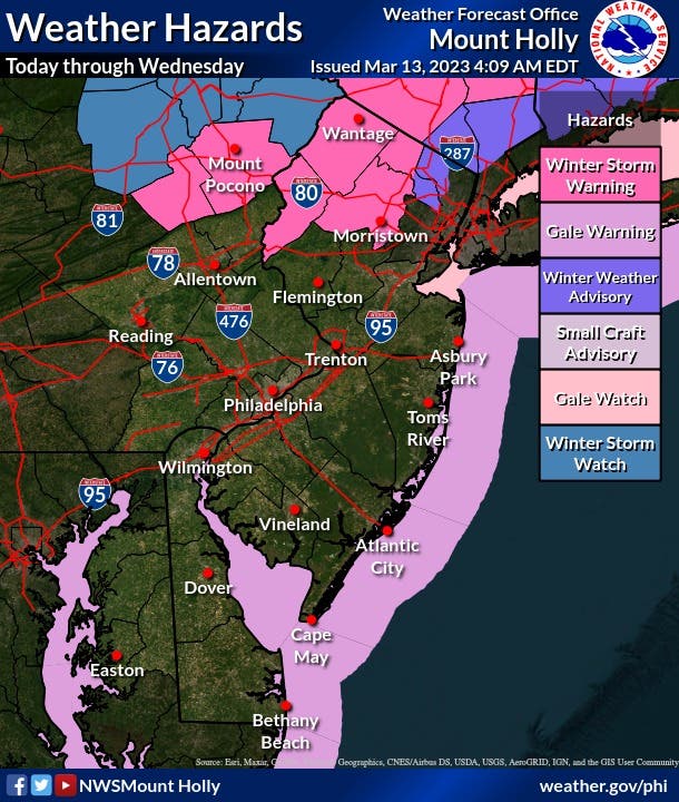
Total accumulations of eight to 12 inches are possible with wind gusts up to 45 miles per hour in Carbon and Monroe counties, which are under a winter storm warning from 6 p.m. Monday evening until 6 p.m. Tuesday. Higher elevations are possible in the Poconos, said the National Weather Service.
Find out what's happening in Across Pennsylvaniafor free with the latest updates from Patch.
A wind advisory is also in effect in east central and southeast Pennsylvania from 1 p.m. Tuesday until midnight. Northwest winds of 25 to 30 miles per hour are expected, with gusts up to 45 miles per hour.
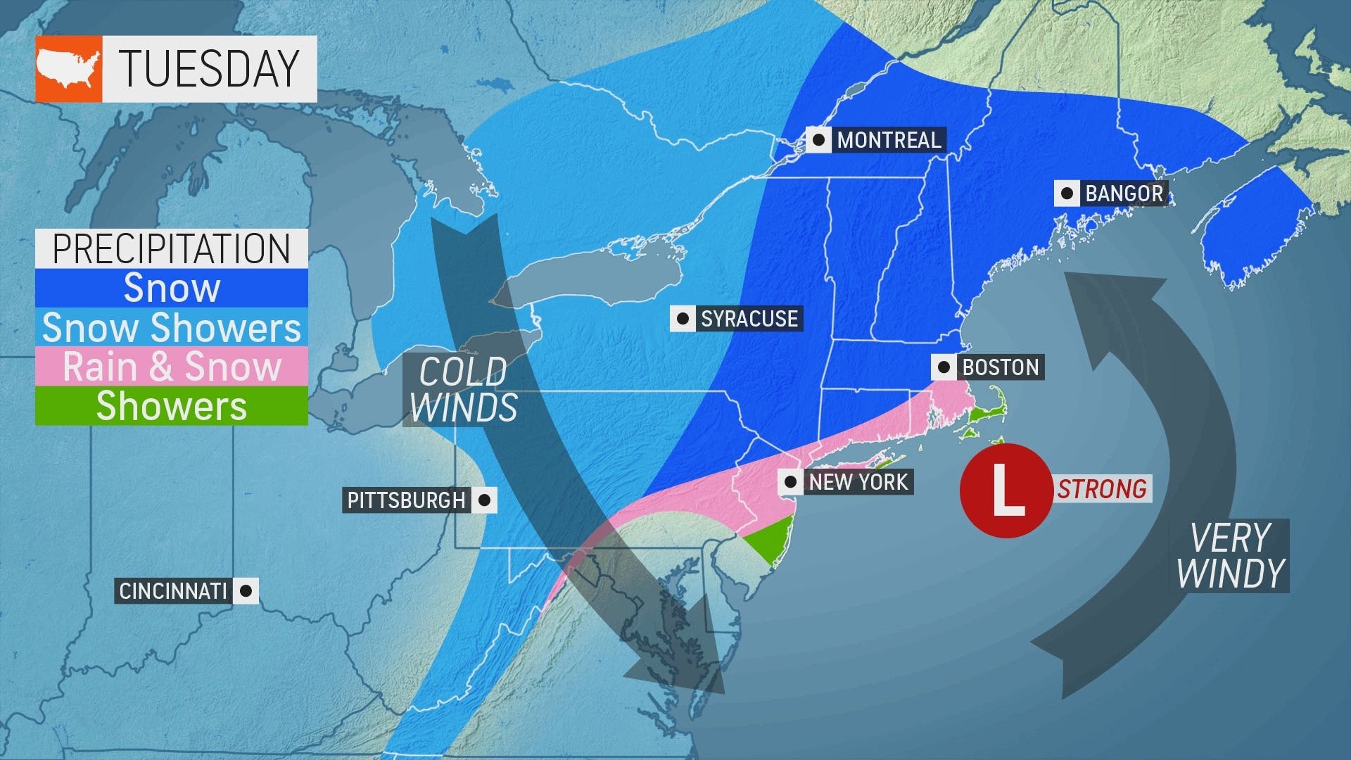
There’s also an enhanced wind risk that could cause power outages throughout the state, with some tree damage possible.
Find out what's happening in Across Pennsylvaniafor free with the latest updates from Patch.
“The snow will be heavy and wet in nature, which can lead to snapped branches and downed power lines,” explained AccuWeather Meteorologist Renee Duff.
The wind is also a risk for the entire area, said forecasters.
AccuWeather says to expect blustery winds ranging from 40-50 mph across central and eastern Pennsylvania.
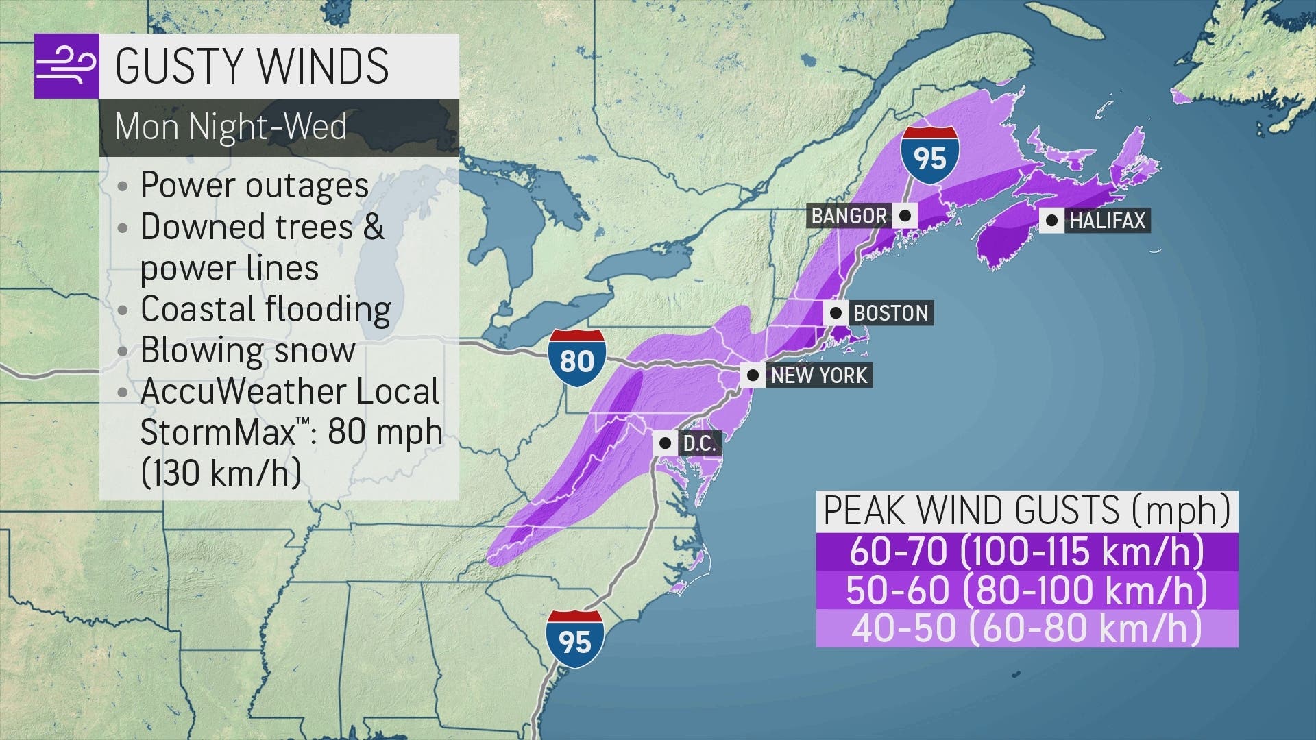
Coastal flooding will also be a concern, AccuWeather forecasters say.
Here is an updated look at the forecast in eastern Pennsylvania:
Monday Night
Rain. Low around 35. Northwest wind 10 to 15 mph. Chance of precipitation is 100%. New precipitation amounts between a half and three quarters of an inch possible.
Tuesday
Rain and snow likely before 2pm, then a chance of rain. Cloudy, with a high near 39. Breezy, with a west wind 20 to 25 mph, with gusts as high as 40 mph. Chance of precipitation is 70%. New snow accumulation of less than a half inch possible.
Tuesday Night
A chance of snow between 7pm and 8pm. Mostly cloudy, with a low around 32. Breezy, with a northwest wind around 25 mph, with gusts as high as 40 mph. Chance of precipitation is 30%. Little or no snow accumulation expected.
Get more local news delivered straight to your inbox. Sign up for free Patch newsletters and alerts.